Hard and Soft Bottom Seafloor Substrate Map Derived from an Unsupervised Classification of Gridded Bathymetry Derivatives for the NOAA Habitat Blueprint West Hawaii Focus Area
Data Set (DS) | Pacific Islands Fisheries Science Center (PIFSC)GUID: gov.noaa.nmfs.inport:12618 | Updated: August 15, 2023 | Published / External
Summary
Short Citation
Pacific Islands Fisheries Science Center, 2024: Hard and Soft Bottom Seafloor Substrate Map Derived from an Unsupervised Classification of Gridded Bathymetry Derivatives for the NOAA Habitat Blueprint West Hawaii Focus Area, https://www.fisheries.noaa.gov/inport/item/12618.
Full Citation Examples
Hard and soft bottom seafloor substrate data and maps for the NOAA Habitat Blueprint West Hawaii Focus Area (WHFA) in the Main Hawaiian Islands. Cell values in the raster datasets reflect whether the seafloor is hard bottom or soft bottom based on an unsupervised classification run using ArcGIS software with the Spatial Analyst extension. The classifications are based on bathymetry, acoustic derivatives and verified using seafloor optical data.
The seafloor substrate map and associated data are accessible online via the Pacific Islands Benthic Habiat Mapping Center (PIBHMC) website at www.soest.hawaii.edu/pibhmc.
Distribution Information
-
Zip file containing hard- and soft-bottom substrates data (shapefile feature class layer) and maps (JPG and PDF) for the Habitat Blueprint West Hawaii Focus Area.
None
These data are not to be used for navigation purposes.
Please cite NOAA Coral Reef Ecosystem Program (CREP) when using the data.
Suggested citation:
Coral Reef Ecosystem Program; Pacific Islands Fisheries Science Center (2016). Hard and Soft Bottom Seafloor Substrate Map Derived from an Unsupervised Classification of Gridded Bathymetry Derivatives for the NOAA Habitat Blueprint West Hawaii Focus Area. https://www.fisheries.noaa.gov/inport/item/12618 [access date]
Controlled Theme Keywords
biota, oceans
Child Items
No Child Items for this record.
Contact Information
Point of Contact
Annette M DesRochers
annette.desrochers@noaa.gov
(808)725-5461
Metadata Contact
Annette M DesRochers
annette.desrochers@noaa.gov
(808)725-5461
Extents
-156.100504° W,
-155.822838° E,
20.061727° N,
19.772429° S
West Hawaii
2006 - 2014
External partner seafloor imagery from:
NOAA Biogeography: 2006-2007
Nature Conservancy: 2010, 2012-2014
Hawaii Institute of Marine Biology: 2011
2006 - 2010
NOAA CREP rapid ecological assessment data
2015 - 2016
External partner multibeam data from main Hawaiian Islands multibeam synthesis maintained by the Hawaii Mapping Research Group
2003
Biogeography Benthic Habitat Maps used for validation
2007
USGS Benthic Habitat Maps used for validation
2012
NOAA CREP TOAD seafloor imagery
2015
NOAA CREP TOAD seafloor imagery
2012
NOAA CREP bathymetry data
Item Identification
| Title: | Hard and Soft Bottom Seafloor Substrate Map Derived from an Unsupervised Classification of Gridded Bathymetry Derivatives for the NOAA Habitat Blueprint West Hawaii Focus Area |
|---|---|
| Short Name: | Hard Soft Substrate: West Hawaii |
| Status: | Completed |
| Publication Date: | 2016 |
| Abstract: |
Hard and soft bottom seafloor substrate data and maps for the NOAA Habitat Blueprint West Hawaii Focus Area (WHFA) in the Main Hawaiian Islands. Cell values in the raster datasets reflect whether the seafloor is hard bottom or soft bottom based on an unsupervised classification run using ArcGIS software with the Spatial Analyst extension. The classifications are based on bathymetry, acoustic derivatives and verified using seafloor optical data. The seafloor substrate map and associated data are accessible online via the Pacific Islands Benthic Habiat Mapping Center (PIBHMC) website at www.soest.hawaii.edu/pibhmc. |
| Purpose: |
Prepared by the NOAA Coral Reef Ecosystem Program (CREP) and funded by the NOAA Coral Reef Conservation Program (CRCP) and NOAA Habitat Blueprint, the maps include but extend beyond the boundaries of the CRCP-designated West Hawaii priority site. The data were derived in support of CRCP goals to map all U.S. Coral Reef Ecosystems by developing high-resolution benthic maps to characterize priority reefs and associated habitats. This derivative of bathymetry provides a GIS layer that may be used for benthic and essential fish habitat characterization, and for the study of geologic features. By combining the dataset with bathymetry, other derivatives, and in-situ data, they collectively compose benthic habitat maps which are designed to be used to understand and predict benthic habitats for different organisms that inhabit coral reef ecosystems. The hard and soft seafloor map is being used for long-term ecosystem monitoring, to guide future ground-truthing operations and to identify coral-rich environments and can be used in the development of actionable policies, plans and management practices. |
| Other Citation Details: |
Suka, R., J. Rooney. 2017. Acoustic Characterization of Mesophotic Coral Reef Ecosystems of West Hawai¿i. U.S. Dep. Commer., NOAA Tech. Memo., NOAA-TM- NMFS-PIFSC-61, 31 p. https://doi.org/10.7289/V5/TM-PIFSC-61. |
| Supplemental Information: |
This is a preliminary product developed by the NOAA Coral Reef Ecosystem Program (CREP) and the methods used to generate the map are planned for publication as a NOAA Technical Memorandum. The bathymetry and optical data collected by NOAA CREP for this project along with the derivative datasets generated by NOAA CREP, including coral cover, slope, rugosity, Bathymetric Position Index Zones, Bathymetric Position Index Structures, and Dominant Benthic Structure and Cover Habitat, are documented and hosted separately on the PIBHMC website at www.soest.hawaii.edu/pibhmc. |
Keywords
Theme Keywords
| Thesaurus | Keyword |
|---|---|
| ISO 19115 Topic Category |
biota
|
| ISO 19115 Topic Category |
oceans
|
| UNCONTROLLED | |
| CoRIS Discovery Thesaurus | Geographic Information > Habitats |
| CoRIS Theme Thesaurus | EARTH SCIENCE > Biosphere > Aquatic Habitat > Benthic Habitat |
| CoRIS Theme Thesaurus | EARTH SCIENCE > Biosphere > Aquatic Habitat > Reef Habitat |
| CoRIS Theme Thesaurus | EARTH SCIENCE > Biosphere > Zoology > Corals > Reef Monitoring and Assessment > GIS |
| CoRIS Theme Thesaurus | EARTH SCIENCE > Biosphere > Zoology > Corals > Reef monitoring and assessment > Mapping |
| CoRIS Theme Thesaurus | EARTH SCIENCE > Biosphere > Zoology > Corals > Reef Monitoring and Assessment > Mapping > geomorphology Mapping |
| CoRIS Theme Thesaurus | EARTH SCIENCE > Biosphere > Zoology > Corals > Reef Monitoring and Assessment > Mapping > Habitat Mapping |
| CoRIS Theme Thesaurus | EARTH SCIENCE > Oceans > Bathymetry/Seafloor Topography > Hard Seafloor Substrate |
| CoRIS Theme Thesaurus | EARTH SCIENCE > Oceans > Bathymetry/Seafloor Topography > Soft Seafloor Substrate |
| CoRIS Theme Thesaurus | EARTH SCIENCE > Oceans > Coastal Processes > Coral Reefs |
| CoRIS Theme Thesaurus | EARTH SCIENCE > Oceans > Coastal Processes > Coral Reefs > Coral Reef Ecology > Habitats |
| CRCP Project | 467 |
| CRCP Project | Mapping and EcoSpatial Information Products to Support Coral Reef Ecosystem Management in the Pacific Islands Region |
| NODC DATA TYPES THESAURUS | SUBSTRATE DESCRIPTION |
| NODC OBSERVATION TYPES THESAURUS | benthic |
| NODC OBSERVATION TYPES THESAURUS | GIS product |
| NODC PROJECT NAMES THESAURUS | Coral Reef Conservation Program |
| NODC SUBMITTING INSTITUTION NAMES THESAURUS | US DOC; NOAA; NMFS; Pacific Islands Fisheries Science Center; Ecosystem Sciences Division; Coral Reef Ecosystem Program |
| None | Coral Reef Ecosystem Division |
| None | Coral Reef Ecosystem Program |
| None | CRED |
| None | CREP |
| None | Pacific Islands Fisheries Science Center |
| None | PIFSC |
| None | Substrate |
Spatial Keywords
| Thesaurus | Keyword |
|---|---|
| UNCONTROLLED | |
| CoRIS Place Thesaurus | COUNTRY/TERRITORY > United States of America > Hawaii > Hawaii > Hawaii (21N160W0000) |
| CoRIS Place Thesaurus | COUNTRY/TERRITORY > United States of America > Hawaii > Hawaii > Hawaii Island (19N155W0003) |
| CoRIS Place Thesaurus | COUNTRY/TERRITORY > United States of America > Hawaii > Hawaii > Kohala Coast (21N155W0001) |
| CoRIS Place Thesaurus | COUNTRY/TERRITORY > United States of America > Hawaii > Hawaii > Puako (19N155W0001) |
| CoRIS Place Thesaurus | OCEAN BASIN > Pacific Ocean > Central Pacific Ocean > Hawaiian Islands > Hawaii > Hawaii (21N160W0000) |
| CoRIS Place Thesaurus | OCEAN BASIN > Pacific Ocean > Central Pacific Ocean > Hawaiian Islands > Hawaii > Kohala Coast (21N155W0001) |
| CoRIS Place Thesaurus | OCEAN BASIN > Pacific Ocean > Central Pacific Ocean > Hawaiian Islands > Hawaii > Puako (19N155W0001) |
| CoRIS Place Thesaurus | OCEAN BASIN > Pacific Ocean > Central Pacific Ocean > Hawaiian Islands > Hawaii Island > Hawaii Island (19N155W0003) |
| NODC SEA AREA NAMES THESAURUS | North Pacific Ocean |
| None | Main Hawaiian Islands |
Stratum Keywords
| Thesaurus | Keyword |
|---|---|
| UNCONTROLLED | |
| Global Change Master Directory | SEA FLOOR |
Physical Location
| Organization: | Pacific Islands Fisheries Science Center |
|---|---|
| City: | Honolulu |
| State/Province: | HI |
| Country: | USA |
Data Set Information
| Data Set Scope Code: | Data Set |
|---|---|
| Data Set Type: | GIS dataset of raster files |
| Maintenance Frequency: | None Planned |
| Data Presentation Form: | Map (digital) |
| Entity Attribute Overview: |
The hard vs soft substrate designation is applied by performing an unsupervised classification on bathymetry data using the Iso Cluster classification tool in ArcGIS. This classification produces two classes, representing hard and soft substrate. |
| Distribution Liability: |
While every effort has been made to ensure that these data are accurate and reliable within the limits of the current state of the art, NOAA cannot assume liability for any damages caused by errors or omissions in the data, nor as a result of the failure of the data to function on a particular system. NOAA makes no warranty, expressed or implied, nor does the fact of distribution constitute such a warranty. |
| Data Set Credit: | PIFSC Coral Reef Ecosystem Program and funded by the NOAA Coral Reef Conservation Program and the NOAA Habitat Blueprint |
Support Roles
Data Steward
| Date Effective From: | 2015 |
|---|---|
| Date Effective To: | |
| Contact (Person): | Suka, Rhonda |
| Address: |
1845 Wasp Blvd. Honolulu, HI 96818 USA |
| Email Address: | rhonda.suka@noaa.gov |
| Phone: | (808)725-5494 |
| Contact Instructions: |
Email preferred |
Distributor
| Date Effective From: | 2015 |
|---|---|
| Date Effective To: | |
| Contact (Person): | Akridge, Michael W |
| Address: |
1845 Wasp Blvd. Honolulu, HI 96818 USA |
| Email Address: | michael.akridge@noaa.gov |
| Phone: | (808)725-5483 |
| Contact Instructions: |
Email preferred |
Metadata Contact
| Date Effective From: | 2015 |
|---|---|
| Date Effective To: | |
| Contact (Person): | DesRochers, Annette M |
| Address: |
1845 Wasp Blvd. Honolulu, HI 96818 USA |
| Email Address: | annette.desrochers@noaa.gov |
| Phone: | (808)725-5461 |
| Business Hours: | 8 am - 5 pm |
| Contact Instructions: |
Email preferred |
Originator
| Date Effective From: | 2015 |
|---|---|
| Date Effective To: | |
| Contact (Organization): | NOAA Coral Reef Conservation Program (CRCP) |
| Address: |
1305 East West Highway 10th Floor Silver Spring, MD 20910-3281 |
| Phone: | (301) 713-3155 |
| URL: | https://coralreef.noaa.gov |
Originator
| Date Effective From: | 2015 |
|---|---|
| Date Effective To: | |
| Contact (Organization): | Pacific Islands Fisheries Science Center (PIFSC) |
| Address: |
1845 Wasp Blvd. Honolulu, HI 96818 USA |
| Email Address: | pifsc.info@noaa.gov |
| Phone: | 808-725-5360 |
| URL: | https://www.pifsc.noaa.gov |
| Business Hours: | 8:00 a.m. - 4:30 p.m. |
Point of Contact
| Date Effective From: | 2015 |
|---|---|
| Date Effective To: | |
| Contact (Person): | DesRochers, Annette M |
| Address: |
1845 Wasp Blvd. Honolulu, HI 96818 USA |
| Email Address: | annette.desrochers@noaa.gov |
| Phone: | (808)725-5461 |
| Business Hours: | 8 am - 5 pm |
| Contact Instructions: |
Email preferred |
Extents
| Currentness Reference: | Ground Condition |
|---|
Extent Group 1
| Extent Description: |
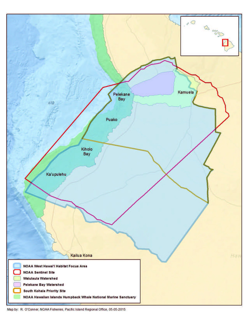
NOAA Habitat Blueprint West Hawaii Focus Area, Hawaii, Main Hawaiian Islands |
|---|
Extent Group 1 / Geographic Area 1
| W° Bound: | -156.100504 | |
|---|---|---|
| E° Bound: | -155.822838 | |
| N° Bound: | 20.061727 | |
| S° Bound: | 19.772429 | |
| Description |
West Hawaii |
|
Extent Group 1 / Time Frame 1
| Time Frame Type: | Range |
|---|---|
| Start: | 2006 |
| End: | 2014 |
| Description: |
External partner seafloor imagery from: NOAA Biogeography: 2006-2007 Nature Conservancy: 2010, 2012-2014 Hawaii Institute of Marine Biology: 2011 |
Extent Group 1 / Time Frame 2
| Time Frame Type: | Range |
|---|---|
| Start: | 2006 |
| End: | 2010 |
| Description: |
NOAA CREP rapid ecological assessment data |
Extent Group 1 / Time Frame 3
| Time Frame Type: | Range |
|---|---|
| Start: | 2015 |
| End: | 2016 |
| Description: |
External partner multibeam data from main Hawaiian Islands multibeam synthesis maintained by the Hawaii Mapping Research Group |
Extent Group 1 / Time Frame 4
| Time Frame Type: | Discrete |
|---|---|
| Start: | 2003 |
| Description: |
Biogeography Benthic Habitat Maps used for validation |
Extent Group 1 / Time Frame 5
| Time Frame Type: | Discrete |
|---|---|
| Start: | 2007 |
| Description: |
USGS Benthic Habitat Maps used for validation |
Extent Group 1 / Time Frame 6
| Time Frame Type: | Discrete |
|---|---|
| Start: | 2012 |
| Description: |
NOAA CREP TOAD seafloor imagery |
Extent Group 1 / Time Frame 7
| Time Frame Type: | Discrete |
|---|---|
| Start: | 2015 |
| Description: |
NOAA CREP TOAD seafloor imagery |
Extent Group 1 / Time Frame 8
| Time Frame Type: | Discrete |
|---|---|
| Start: | 2012 |
| Description: |
NOAA CREP bathymetry data |
Access Information
| Security Class: | Unclassified |
|---|---|
| Security Classification System: |
Not applicable |
| Security Handling Description: |
Not applicable |
| Data Access Policy: |
NOAA Coral Reef Ecosystem Program (CREP) Data Sharing Recommendations, version 9.0 updated August 12, 2015: CREP welcomes the opportunity to collaborate on research issues contributing to the scientific basis for better management of marine ecosystems. CREP has a very diverse set of field activities that generates large volumes of data using an array of data collection protocols. The following recommendations are for your consideration as you use this data: 1) Data analyses should take all field exigencies into account. The most effective way to do this would be active collaboration with CREP principal investigators. 2) In all presentations, product releases, or publications using data generated by CREP, proper acknowledgement of both CREP and the individuals responsible for data collection is expected. Citing the DOI (if available) is preferred, a non-DOI example is listed below. 3) If you collect or generate data for the same study areas, CREP requests that you share relevant information on complimentary data collections. 4) Those receiving data are strongly urged to inform the CREP Data Management Team of any errors and discrepancies that are discovered during the course of using these data. They are further urged to bring to the attention of the Team all problems and difficulties encountered in using these data. This information is necessary in order to improve the collections and to facilitate more efficient and economical data processing and retrieval. The users are asked to supply copies of any missing data that may be located, and to provide information as to significant subsets and special aggregations of data that are developed in using the material provided. Example citation: "This publication makes use of data products provided by the Coral Reef Ecosystem Program (CREP), Pacific Islands Fisheries Science Center (PIFSC), National Marine Fisheries Service (NMFS), National Oceanic and Atmospheric Administration (NOAA), with funding support from the NOAA Coral Reef Conservation Program (CRCP) and NOAA Habitat Blueprint. The analysis and interpretations presented here are solely that of the current authors.†|
| Data Access Procedure: |
Data can be accessed online via the Pacific Islands Benthic Habitat Mapping Center website at https://www.soest.hawaii.edu/pibhmc/pibhmc_mhi_haw.htm |
| Data Access Constraints: |
None |
| Data Use Constraints: |
These data are not to be used for navigation purposes. Please cite NOAA Coral Reef Ecosystem Program (CREP) when using the data. Suggested citation: Coral Reef Ecosystem Program; Pacific Islands Fisheries Science Center (2016). Hard and Soft Bottom Seafloor Substrate Map Derived from an Unsupervised Classification of Gridded Bathymetry Derivatives for the NOAA Habitat Blueprint West Hawaii Focus Area. https://www.fisheries.noaa.gov/inport/item/12618 [access date] |
| Metadata Access Constraints: |
None |
| Metadata Use Constraints: |
None |
Distribution Information
Distribution 1
| Download URL: | ftp://ftp.soest.hawaii.edu/pibhmc/website/data/mhi/benthichabitatlayers/WestHawaii_hardsoft.zip |
|---|---|
| Distributor: | |
| File Name: | WestHawaii_hardsoft.zip |
| Description: |
Zip file containing hard- and soft-bottom substrates data (shapefile feature class layer) and maps (JPG and PDF) for the Habitat Blueprint West Hawaii Focus Area. |
| File Type (Deprecated): | Zip |
| Compression: | Zip |
URLs
URL 1
| URL: | http://www.soest.hawaii.edu/pibhmc/index.htm |
|---|---|
| URL Type: |
Online Resource
|
| File Resource Format: | HTML |
| Description: |
Pacific Islands Benthic Habitat Mapping Center (PIBHMC) website. All data are accessible through this website. |
URL 2
| URL: | https://www.habitatblueprint.noaa.gov/habitat-focus-areas/west-hawaii/ |
|---|---|
| URL Type: |
Online Resource
|
| File Resource Format: | HTML |
| Description: |
NOAA Habitat Blueprint West Hawaii Focus Area website |
URL 3
| URL: | https://www.habitatblueprint.noaa.gov/storymap/hfa/hfa_pages/images/westHawaii/location_map.jpg |
|---|---|
| URL Type: |
Browse Graphic
|
| File Resource Format: | JPG |
| Description: |
NOAA Habitat Blueprint West Hawaii Focus Area |
Technical Environment
| Description: |
ArcGIS desktop and tools including Benthic Terrain Modeler (BTM), and from the ArcGIS Spatial Analyst extension the Principle Components Analysis (PCA) and the Iso Cluster Unsupervised Classification tools. |
|---|
Data Quality
| Representativeness: |
Hard- and soft-bottom substrate classifications are primarily derived from gridded bathymetry data that is collected from a number of NOAA vessels using multibeam sonars. This multibeam data may be synthesized with other data including bathymetric LiDAR . Multibeam data collection targets waters ranging from ~20 m to 500 m depths. Bathymetric LiDAR target waters less than 20-m depths. The goal of all data collection is to collect data over the entire seafloor within 0-500 m depths. |
|---|---|
| Accuracy: |
Horizontal positioning system: GPS C/A Horizontal position accuracy: 25 m Range resolution of sonar: varies with depth Raw sounding resolution: varies with depth Vertical accuracy of gridded product ~ 1% of water depth |
| Completeness Report: |
Hard- and soft-bottom substrates were determined for all areas where gridded bathymetry data were available. Some gaps exist in bathymetry coverage due to 1) hazardous conditions that prohibited access for the NOAA vessels, 2) limited time, or 3) limited funding resources. |
| Conceptual Consistency: |
Multibeam bathymetry data were collected by different NOAA vessels using the same collection methods. All multibeam data collected by the Coral Reef Ecosystem Program (CREP) was processed in the same manner. All bathymetry synthesis data used as source data for the products generated for the Main Hawaiian Islands were processed in the same manner by the Hawaii Mapping Research Group. Seafloor imagery was collected by a number of different external partners using different methods; however, all imagery included in this project for the purposes of ground truthing was classified by CREP using the same classification scheme by experienced image analysts that are tested and calibrated annually. |
| Quality Control Procedures Employed: |
Corrections for tide variation and vessel attitude are applied to the multibeam data and a CTD (Conductivity, Temperature, and Depth instrument) cast is performed regularly during data collection to correct for variance within the water column. Multibeam data are tested for internal consistency; however, no effort is made to compare these data to external references or to other published data. Hard/soft results from unsupervised classification were validated and corrected using optical ground truth imagery. |
Data Management
| Have Resources for Management of these Data Been Identified?: | Yes |
|---|---|
| Approximate Percentage of Budget for these Data Devoted to Data Management: | Unknown |
| Do these Data Comply with the Data Access Directive?: | Yes |
| Is Access to the Data Limited Based on an Approved Waiver?: | No |
| Approximate Delay Between Data Collection and Dissemination: | Unknown |
| Actual or Planned Long-Term Data Archive Location: | NCEI-MD |
| Approximate Delay Between Data Collection and Archiving: | Unknown |
| How Will the Data Be Protected from Accidental or Malicious Modification or Deletion Prior to Receipt by the Archive?: |
University of Hawaii School of Ocean and Earth Science and Technology, NOAA IRC and NOAA Fisheries ITS resources and assets. |
Lineage
| Lineage Statement: |
The Iso Cluster Unsupervised Classification tool in ArcGIS was used to classify the three-band Principle Component Analysis image into two distinct hard vs soft substrate classes. Ground truth optical imagery as well as existing shallow water habitat maps provided by the USGS and NOAA Biogeography Branch were used to validate and correct the hard soft classification. |
|---|
Sources
5m Bathymetric data of Kohala coast of Hawaii
| Contact Type: | Organization |
|---|---|
| Contact Name: | Pacific Islands Fisheries Science Center, PIFSC |
| Publish Date: | 2015-09-01 |
| Extent Type: | Range |
| Extent Start Date/Time: | 2012-06-09 |
| Extent End Date/Time: | 2012-06-29 |
| Citation URL: | http://www.soest.hawaii.edu/pibhmc/pibhmc_mhi_haw_bathy.htm |
Cochran, S.A., Gibbs, A.E., and Logan, J.B., 2007, Geologic Resource Evaluation of Pu'ukohola Heiau National Historic Site, Hawaii; Part II, Benthic habitat mapping: U.S. Geological Survey Scientific Investigations Report 2006-5254, 20 p.
| Contact Name: | United States Geological Survey |
|---|---|
| Publish Date: | 2006-09-28 |
| Extent Type: | Range |
| Extent Start Date/Time: | 2004-04 |
| Extent End Date/Time: | 2004-08 |
| Citation URL: | http://pubs.usgs.gov/sir/2006/5256/ |
Costa BM and Battista TA (2013) The semi-automated classification of acoustic imagery for characterizing coral reef ecosystems. International Journal of Remote Sensing 34(18):6389–6422.
| Contact Type: | Organization |
|---|---|
| Contact Name: | National Centers for Coastal Ocean Science, NCCOS |
| Publish Date: | 2013-06-10 |
| Citation URL: | http://dx.doi.org/10.1080/01431161.2013.800661 |
Coyne, M. S., T. A. Battista, M. Anderson, J. Waddell, W. Smith, P. Jokiel, M. S. Kendall and M. E. Monaco. 2003. Benthic Habitats of the Main Hawaiian. NOAA Technical Memorandum NOS NCCOS CCMA 152. Silver Spring, MD. 48 pp
| Contact Type: | Organization |
|---|---|
| Contact Name: | National Centers for Coastal Ocean Science, NCCOS |
| Publish Date: | 2003-11-01 |
| Extent Type: | Discrete |
| Extent Start Date/Time: | 2000 |
| Citation URL: | https://www.coastalscience.noaa.gov/publications/detail?resource=qejBv6ZUKKXwNsGgQLkqzyhtjF6CMlv8jyS737Ib/Fg= |
Iso Cluster Unsupervised Classification Tool
| Contact Name: | Esri |
|---|---|
| Citation URL: | http://desktop.arcgis.com/en/arcmap/latest/extensions/spatial-analyst/image-classification/executing-the-iso-cluster-unsupervised-classification-tool.htm |
Main Hawaiian Islands Multibeam Bathymetry Synthesis
| Contact Name: | University of Hawaii, Hawaii Mapping Research Group |
|---|---|
| Citation URL: | http://www.soest.hawaii.edu/HMRG/multibeam/bathymetry.php |
Wright, D.J., Pendleton, M., Boulware, J., Walbridge, S., Gerlt, B., Eslinger, D., Sampson, D., and Huntley, E. 2012. ArcGIS Benthic Terrain Modeler (BTM), v. 3.0, Environmental Systems Research Institute, NOAA Coastal Services Center, Massachusetts Office of Coastal Zone Management.
| Contact Name: | ESRI, NOAA Coastal Services Center, Mass. Office of Coastal Zone Management |
|---|---|
| Publish Date: | 2012-11-14 |
| Citation URL: | http://esriurl.com/5754 |
Process Steps
Process Step 1
| Description: |
Multibeam bathymetry data collected by NOAA CREP was processed and integrated with existing bathymetry datasets maintained by the University of Hawaii, Hawaii Mapping Research Group (HMRG) to produce a high-resolution (5m) bathymetry synthesis for the entire NOAA Habitat Blueprint West Hawaii Focus Area (WHFA). |
|---|---|
| Source: | 5m Bathymetric data of Kohala coast of Hawaii |
Process Step 2
| Description: |
The Benthic Terrain Modeler in ArcGIS 10.3 was used to derive a series of surface complexity layers using the WHFA bathymetry synthesis. Eight surface complexity layers (mean depth, standard deviation of depth, curvature, plan curvature, profile curvature, slope, slope of slope, and rugosity) and Bathymetric Position Index (BPI) layers for zone and structure were produced. |
|---|---|
| Source: | Wright, D.J., Pendleton, M., Boulware, J., Walbridge, S., Gerlt, B., Eslinger, D., Sampson, D., and Huntley, E. 2012. ArcGIS Benthic Terrain Modeler (BTM), v. 3.0, Environmental Systems Research Institute, NOAA Coastal Services Center, Massachusetts Office of Coastal Zone Management. |
Process Step 3
| Description: |
A Principle Component Analysis (PCA) using ENVI 5.3 software was performed on the bathymetry synthesis and eight complexity surface layers to remove highly correlated data by transforming the image into nine principle components. The first three principle components described 99% of the data variability. The complexity surfaces that contributed the most variance were depth, mean depth and rugosity. These three principle components were retained for use in the benthic classification process.
|
|---|---|
| Source: | Costa BM and Battista TA (2013) The semi-automated classification of acoustic imagery for characterizing coral reef ecosystems. International Journal of Remote Sensing 34(18):6389–6422. |
Process Step 4
| Description: |
The Iso Cluster Unsupervised Classification tool in ArcGIS was used to classify the three-band Principle Component Analysis image into two distinct hard vs soft substrate classes. |
|---|---|
| Source: | Iso Cluster Unsupervised Classification Tool |
Process Step 5
| Description: |
To verify the accuracy of the automated delineation, the classified optical validation points were overlaid onto the delineated image to confirm or correct the substrate classes. The delineated classifications were manually corrected if they disagreed with the optical validation points. When optical validation points were absent, the USGS and NOAA Biogeography Branch benthic habitat maps were used as validation. |
|---|
Related Items
Catalog Details
| Catalog Item ID: | 12618 |
|---|---|
| GUID: | gov.noaa.nmfs.inport:12618 |
| Metadata Record Created By: | Annette M DesRochers |
| Metadata Record Created: | 2012-07-12 21:52+0000 |
| Metadata Record Last Modified By: | SysAdmin InPortAdmin |
| Metadata Record Last Modified: | 2023-08-15 17:09+0000 |
| Metadata Record Published: | 2017-01-09 |
| Owner Org: | PIFSC |
| Metadata Publication Status: | Published Externally |
| Do Not Publish?: | N |
| Metadata Last Review Date: | 2017-01-09 |
| Metadata Review Frequency: | 1 Year |
| Metadata Next Review Date: | 2018-01-09 |