Derived bathymetry from IKONOS satellite imagery of nearshore benthic habitats
Data Set (DS) | Pacific Islands Fisheries Science Center (PIFSC)GUID: gov.noaa.nmfs.inport:25280 | Updated: October 17, 2023 | Published / External
Summary
Short Citation
Pacific Islands Fisheries Science Center, 2024: Derived bathymetry from IKONOS satellite imagery of nearshore benthic habitats, https://www.fisheries.noaa.gov/inport/item/25280.
Full Citation Examples
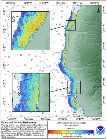
Methods used were adapted from a "cookbook" of instructions developed by Kyle Hogref
for using IKONOS imagery data to derive seafloor elevations in optically clear
water. This dataset was derived from high-resolution (2 m) imagery from DigitalGlobe's
WorldView-2 sensor of the Kaanapali area of Maui, Hawaii. Sensor bands 1,2
and 5 (coastal, blue and near IR respectively) were used to derive depth information.
The method assumes uniform water clarity but deviations from that condition
made extraction difficult in water greater than 30 m depth in the Kaanapali scene
used. Results show that biotic material or sediment in the water column skewed results
shallower if the material has a high albedo and deeper if the material has a low
albedo. Nearshore areas were significantly less impacted in the Kaanapali area,
due to the geomorphology of the area and the hi resolution and quality of the imagery,
allowing visual descrimination of apparent sediment in the water column.
For presentation purposes the map product shows an Inverse Distance Weighted interpolated
bathymetry surface, restricted to data within 600 m of the shoreline.
Distribution Information
-
NC - NetCDF
none
These data are not to be used for navigation purposes. Please acknowledge the NOAA Pacific Islands Fisheries Science Center,
and the Joint Institute for Marine and Atmospheric Research (JIMAR) and Hawaii
Mapping Research Group (HMRG) at the University of Hawaii as the sources of
this information.
Controlled Theme Keywords
elevation
Child Items
No Child Items for this record.
URLs
URL 1
| URL: | http://www.soest.hawaii.edu/pibhmc/pibhmc_mhi_mai_bathy.htm |
|---|---|
| URL Type: |
Online Resource
|
| File Resource Format: | HTM |
URL 2
| URL: | http://www.soest.hawaii.edu/pibhmc/MHI_images/KaanapaliDerivedBathy_445.jpg |
|---|---|
| URL Type: |
Browse Graphic
|
| File Resource Format: | JPEG |
| Description: |
Layout of data on original satellite imagery |