Fish, Benthic and Urchin Survey Data from Kahekili Herbivore Fisheries Management Area (HFMA), Maui since 2008
Data Set (DS) | Pacific Islands Fisheries Science Center (PIFSC)GUID: gov.noaa.nmfs.inport:30951 | Updated: October 17, 2023 | Published / External
Summary
Short Citation
Pacific Islands Fisheries Science Center, 2024: Fish, Benthic and Urchin Survey Data from Kahekili Herbivore Fisheries Management Area (HFMA), Maui since 2008, https://www.fisheries.noaa.gov/inport/item/30951.
Full Citation Examples
Data are summary fish, benthic and urchin data from belt transect surveys conducted by the Pacific Islands Fisheries Science Center (PIFSC) Ecosystem Sciences Division (ESD; formerly the Coral Reef Ecosystem Division) within the Kahekili Herbivore Fisheries Management Area (KHFMA) in West Maui.
Surveys were completed in 'rounds', each round being an intensive 4 day survey effort (occasionally with an additional day soon after) from 2009 to 2021. Also included are data gathered by Hawaii Division of Aquatic Resources (HDAR) in 2008 at the same locations and using the same survey design and methods.
Each row represents a single survey of a 25-m haphazardly located transect within the KHFMA. All transects are included. Habitat types are SAG (shallow aggregate reef); DAG (deep aggregate reef); MMX (mixed mid-depth reef); SSG (shallow spur and groove); DSG (deep spur and groove); and SPA (shallow pavement).
Benthic cover (%) is extracted from a photo-transect (25 photographs taken at 1-m intervals, 15+ points analyzed per photograph using image analysis softwares PhotoGrid or CoralNet). -9 values represent situations where images were either not gathered or not analyzed.
Fishes are surveyed by means of a diver swimming outward and return swims along the same transect. On the outward swims, the diver records all fishes >15 cm total length (TL) within a 4-m wide belt centered on the diver; on the return swim, divers record fishes <15 cm TL within a 2-m wide belt. Fish species and size observations are converted to biomass (grams per square meter, or g/m^2) using species-specific length-weight conversion parameters. Urchins are counted on a 1-m wide belt centered on the transect line. Urchin density is calculated by the number per square meter (#/m^2).
Distribution Information
-
CSV - Comma Separated Values (Text)
Summarized fish, benthic and urchin data from monitoring surveys within the Kahekili Herbivore Fisheries Management Area (KHFMA), Maui since 2008 through surveys conducted in November 2021. Each row in the dataset represents a single survey of a 25 m haphazardly located transect within the KHFMA. The previous accession (0146683) was deprecated and replaced by this accession.
If navigating the HTTPS direct download of individual files, this file can be accessed with this more specific link: https://www.nodc.noaa.gov/archive/arc0111/0165015/3.3/data/0-data/Kahekili_HFMA/Data/
-
CSV - Comma Separated Values (Text), 22 KB
Data Dictionary
None
Please cite Ecosystem Sciences Division (ESD) and acknowledge Hawaii Division of Aquatic Resources (HDAR) when using the data.
Example:
Cite as: Williams, Ivor; PIFSC Coral Reef Ecosystem Program (2017). Fish, Benthic and Urchin Survey Data from Kahekili Herbivore Fisheries Management Area (HFMA), Maui, HI since 2008 (NCEI Accession 0165015). Version 1.1. NOAA National Centers for Environmental Information. Dataset. [access date]
Controlled Theme Keywords
biota
Child Items
| Type | Title |
|---|---|
| Entity | Kahekili Entities |
URLs
URL 1
| URL: | https://www.facebook.com/KHFMA |
|---|---|
| URL Type: |
Online Resource
|
| File Resource Format: | HTML |
| Description: |
Kahekili Herbivore Fisheries Management Area Facebook page. |
URL 2
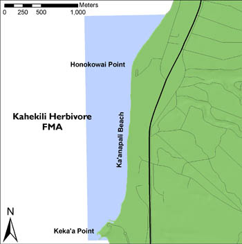
| URL: | http://dlnr.hawaii.gov/dar/files/2014/05/kahekili.jpg |
|---|---|
| URL Type: |
Browse Graphic
|
| File Resource Format: | JPG |
| Description: |
Map of Kahekili Herbivore Fishery Management Area |
Child Items
Rubric scores updated every 15m
| Type | Title |
|---|---|
| Entity | Kahekili Entities |