Sensitivity of Coastal Environments and Wildlife to Spilled Oil: Florida Panhandle: INDEX (Index Polygons)
Data Set (DS) | Office of Response and Restoration (ORR)GUID: gov.noaa.nmfs.inport:40718 | Updated: May 30, 2023 | Published / External
Summary
Short Citation
Office of Response and Restoration, 2024: Sensitivity of Coastal Environments and Wildlife to Spilled Oil: Florida Panhandle: INDEX (Index Polygons), https://www.fisheries.noaa.gov/inport/item/40718.
Full Citation Examples
This data set contains vector polygons representing the boundaries of all hardcopy cartographic products produced as part of the Environmental Sensitivity Index (ESI) for the Florida Panhandle. This data set comprises a portion of the ESI data for the Florida Panhandle. ESI data characterize the marine and coastal environments and wildlife by their sensitivity to spilled oil. The ESI data include information for three main components: shoreline habitats, sensitive biological resources, and human-use resources.
Distribution Information
-
Downloadable Data
None
DO NOT USE MAPS FOR NAVIGATIONAL PURPOSES.
Besides the above warning, there are no use constraints on these data. Note that the ESI database should not be used to the exclusion of other pertinent data or information held by state or federal agencies or other organizations. Likewise, information contained in the database cannot be used in place of consultations with environmental, natural resource, and cultural resource agencies, or in place of field surveys. Recognize that the information contained in the ESI database represents known concentration areas or occurrences of natural, cultural, and human-use resources, but does not necessarily represent the full distribution or range of each species or resource. This is particularly important to recognize when considering potential impacts to protected resources, such as endangered species, wetlands, etc. Acknowledgment of the originators, publishers, contributors, and sources listed would be appreciated in products derived from these data.
Controlled Theme Keywords
biota, environment
Child Items
| Type | Title |
|---|---|
| Entity | INDEX.PAT |
URLs
URL 1
| URL: | http://response.restoration.noaa.gov/esi |
|---|---|
| URL Type: |
Online Resource
|
URL 2
| URL: | http://response.restoration.noaa.gov/esi_download |
|---|---|
| URL Type: |
Online Resource
|
URL 3
| URL: | http://response.restoration.noaa.gov/esi_guidelines |
|---|---|
| URL Type: |
Online Resource
|
URL 4
| URL: | http://response.restoration.noaa.gov/sites/default/files/esimaps/gisdata/FloridaPanhdle_2012_datafig.jpg |
|---|---|
| URL Type: |
Browse Graphic
|
| File Resource Format: | JPEG |
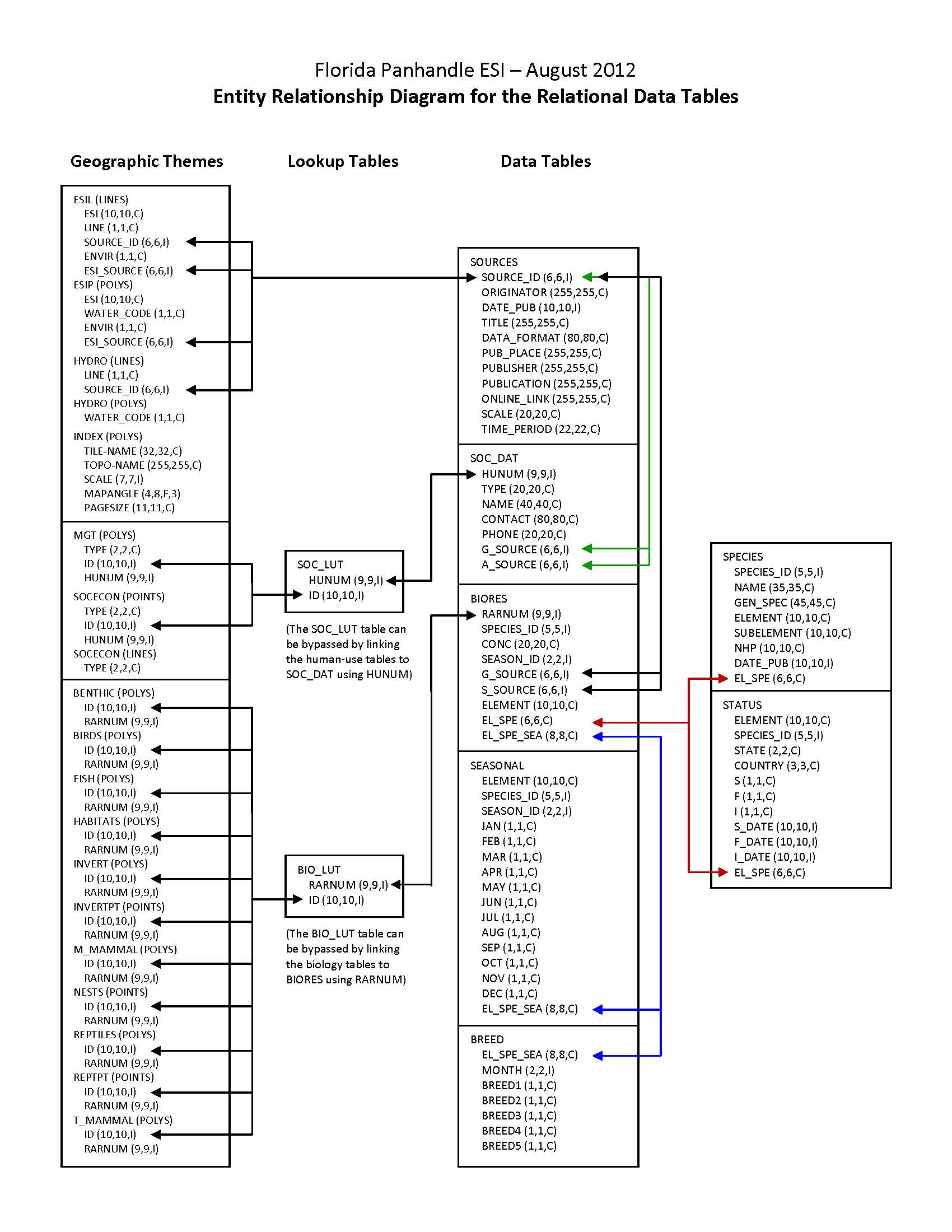
| Description: |
Depicts the relationships between spatial data layers and attribute data tables for the Florida Panhandle ESI data. |
URL 5
| URL: | http://response.restoration.noaa.gov/sites/default/files/esimaps/gisdata/FloridaPanhdle_2012_datafig2.jpg |
|---|---|
| URL Type: |
Browse Graphic
|
| File Resource Format: | JPEG |
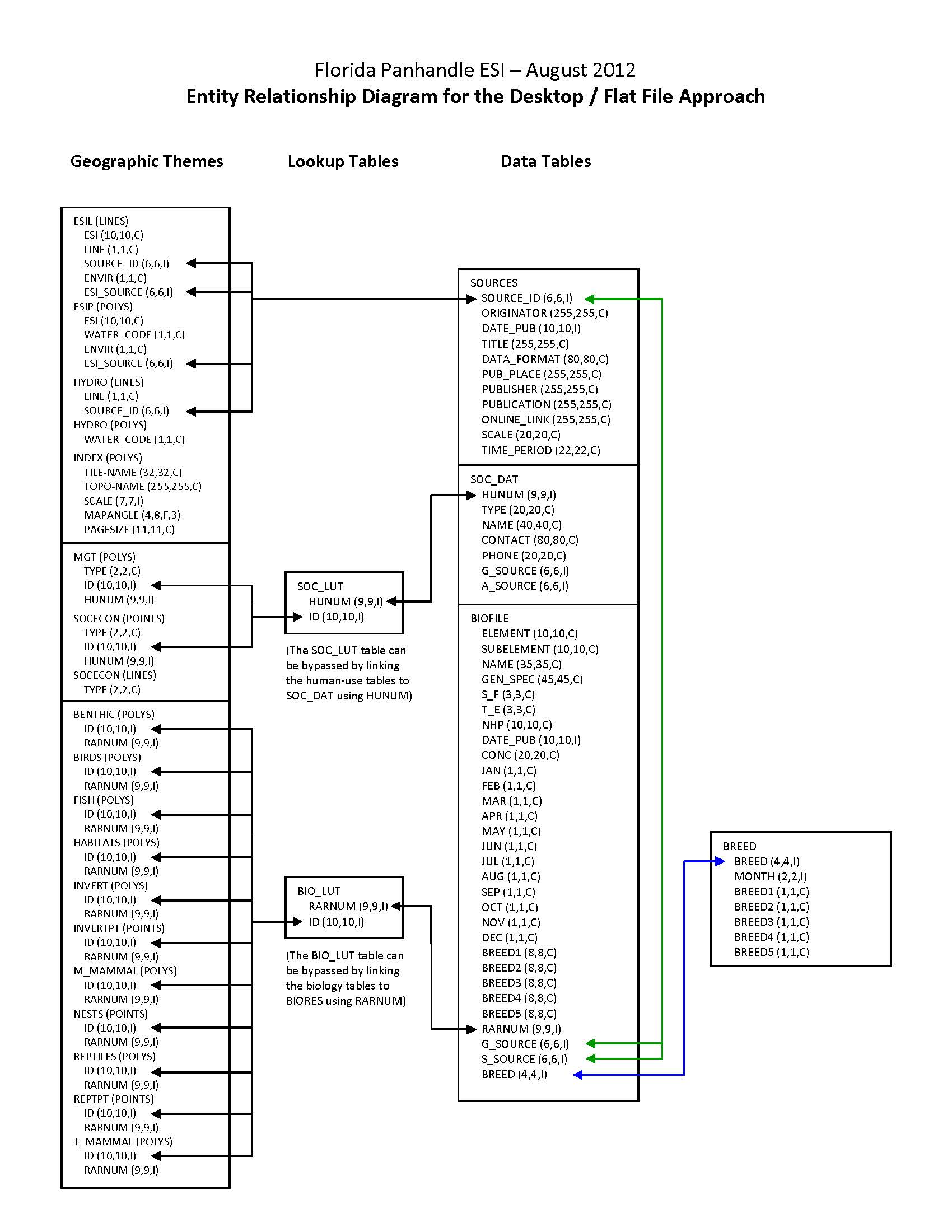
| Description: |
Depicts the relationships between spatial data layers and desktop data tables for the Florida Panhandle ESI data. |
Child Items
Rubric scores updated every 15m
| Type | Title |
|---|---|
| Entity | INDEX.PAT |