Benthic percent cover derived from analysis of benthic images collected at coral reef sites in Timor-Leste in 2013 and 2014
Data Set (DS) | Pacific Islands Fisheries Science Center (PIFSC)GUID: gov.noaa.nmfs.inport:46161 | Updated: October 17, 2023 | Published / External
Summary
Short Citation
Pacific Islands Fisheries Science Center, 2024: Benthic percent cover derived from analysis of benthic images collected at coral reef sites in Timor-Leste in 2013 and 2014, https://www.fisheries.noaa.gov/inport/item/46161.
Full Citation Examples
The benthic cover data described here result from benthic photo-quadrat surveys conducted by the NOAA Coral Reef Ecosystem Program (CREP) in hard bottom shallow water (< 15 m) habitats in Timor-Leste during reef fish surveys surveys at 150 sites that were selected using a stratified random sampling design in June 2013, and along transects at fixed climate survey sites in September-October 2014 (10 sites and 8 sites, respectively).
Climate sites were established by CREP to establish ecological baselines for climate change by measuring multiple features of the coral reef environment (in addition to the data described herein) over time. The reef fish surveys were conducted to generate baseline data on the nearshore coral reef fish assemblages and associated benthic communities around Timor-Leste's north coast and Atauro Island.
Percent benthic cover for each site is estimated from a photo-transect (30 photographs, taken at 1-m intervals, 10+ points analyzed per photograph using Coral Point Count with Extensions). NA values represent situations where images were either not gathered or not analyzed.
These benthic cover data for Timor-Leste provide an estimate of the benthic community composition at each survey site, and give context to the results from the other survey components. The benthic images, and the associated reef fish survey data and parameters measured to establish ecological baselines for climate change are documented separately. The data can be accessed online via the NOAA National Centers for Environmental Information (NCEI) Ocean Archive.
Distribution Information
-
CSV - Comma Separated Values (Text)
Benthic cover classification codes (definitions included in entities and attributes section).
-
CSV - Comma Separated Values (Text)
Image analysis data derived from photoquadrat benthic images collected by the NOAA Coral Reef Ecosystem Program (CREP) at climate survey sites in Timor-Leste in 2014. File contains data for each point analyzed for a photograph (10 points each site). Habitat information (HABITAT_CODE) was not recorded.
-
CSV - Comma Separated Values (Text)
Image analysis data derived from photoquadrat benthic images collected by the NOAA Coral Reef Ecosystem Program (CREP) at reef fish survey sites in Timor-Leste in 2013. File contains data for each point analyzed for a photograph (10 points each site).
-
CSV - Comma Separated Values (Text)
Image analysis data derived from photoquadrat benthic images collected by the NOAA Coral Reef Ecosystem Program (CREP) at climate survey sites in Timor-Leste in 2014. File summarizes data for each photograph analyzed (one record = 1 photograph = data from 10 points analyzed)
-
CSV - Comma Separated Values (Text)
Image analysis data derived from photoquadrat benthic images collected by the NOAA Coral Reef Ecosystem Program (CREP) at reef fish survey sites in Timor-Leste in 2013. File summarizes data for each photograph analyzed (one record = 1 photograph = data from 10 points analyzed)
-
CSV - Comma Separated Values (Text)
Image analysis data derived from photoquadrat benthic images collected by the NOAA Coral Reef Ecosystem Program (CREP) at climate survey sites in Timor-Leste in 2014. File summarizes data for each survey site (1 record = 1 site = ~30 photographs analyzed).
-
CSV - Comma Separated Values (Text)
Image analysis data derived from photoquadrat benthic images collected by the NOAA Coral Reef Ecosystem Program (CREP) at reef fish survey sites in Timor-Leste in 2013. File summarizes data for each survey site (1 record = 1 site = ~30 photographs analyzed).
None
Please cite NOAA Coral Reef Ecosystem Program (CREP) when using the data.
Example:
Coral Reef Ecosystem Program; Pacific Islands Fisheries Science Center (2017). Benthic percent cover derived from analysis of benthic images collected at coral reef sites in Timor-Leste in 2013 and 2014. NOAA's National Center for Environmental Information. Dataset. https://www.fisheries.noaa.gov/inport/item/46161
Controlled Theme Keywords
biota
Child Items
| Type | Title |
|---|---|
| Entity | Benthic Image analysis classification scheme |
| Entity | Table: BIA_PERC_COVER_PHOTO_TIMOR |
URLs
URL 1
| URL: | http://cnso.nova.edu/cpce/index.html |
|---|---|
| URL Type: |
Online Resource
|
| File Resource Format: | HTML |
| Description: |
Coral Point Count with Excel extensions website. |
URL 2
| URL: | https://www.coris.noaa.gov/activities/projects/timor-leste/ |
|---|---|
| URL Type: |
Online Resource
|
| File Resource Format: | HTML |
| Description: |
Timor-Leste project portal on the NOAA Coral Reef Information Service website where NOAA's final report for Timor-Leste and the datasets generated by NOAA CREP as part of the project can be downloaded. |
URL 3
| URL: | https://www.coris.noaa.gov/activities/projects/timor-leste/images/benthic_cover_graph_fish_s.jpg |
|---|---|
| URL Type: |
Browse Graphic
|
| File Resource Format: | JPG |
| Description: |
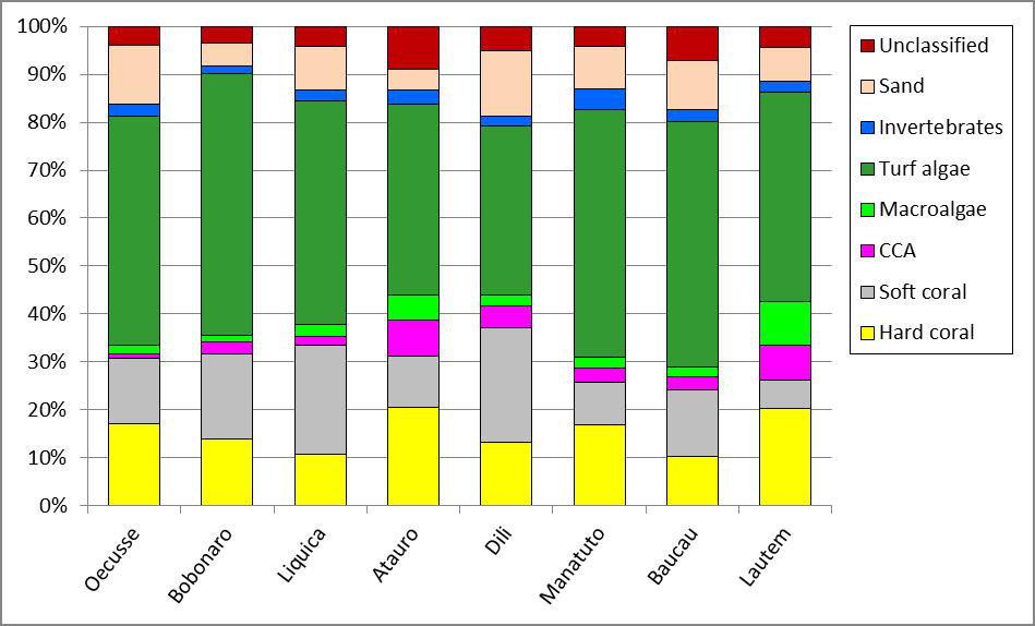
An example chart of the benthic cover data for Timor-Leste. |
URL 4
| URL: | https://www.pifsc.noaa.gov/cred/coral_triangle_initiative.php |
|---|---|
| URL Type: |
Online Resource
|
| File Resource Format: | PHP |
| Description: |
Information about the NOAA Coral Reef Ecosystem Program's activities in the Coral Triangle. |
URL 5
| URL: | https://pifscblog.wordpress.com/2013/08/13/final-count-timor-leste-2/ |
|---|---|
| URL Type: |
Online Resource
|
| File Resource Format: | html |
| Description: |
PIFSC CREP blog post, 2013: The final count: summary of mission to assess reef fish assemblages, build capacity in Timor-Leste. |
URL 6
| URL: | https://pifscblog.wordpress.com/2014/09/30/timor-leste-atauro/ |
|---|---|
| URL Type: |
Online Resource
|
| File Resource Format: | HTML |
| Description: |
PIFSC CREP blog post, 2014: Scientists return to Timor-Leste for reef monitoring mission. |
Child Items
Rubric scores updated every 15m
| Type | Title |
|---|---|
| Entity | Benthic Image analysis classification scheme |
| Entity | Table: BIA_PERC_COVER_PHOTO_TIMOR |