Gridded multibeam bathymetry of Baker Island, Pacific Remote Island Areas, Central Pacific
Data Set (DS) | Pacific Islands Fisheries Science Center (PIFSC)GUID: gov.noaa.nmfs.inport:47744 | Updated: August 15, 2023 | Published / External
Summary
Short Citation
Pacific Islands Fisheries Science Center, 2024: Gridded multibeam bathymetry of Baker Island, Pacific Remote Island Areas, Central Pacific, https://www.fisheries.noaa.gov/inport/item/47744.
Full Citation Examples
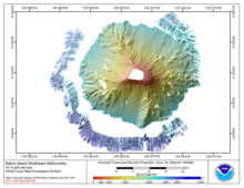
Gridded bathymetry at 40m resolution surrounding Baker Island, within the Pacific Remote Island Areas - Central Pacific Ocean. Bottom coverage was achieved in depths between 8 and 4700 meters. The Arc ASCII grids and floating point geotifs include multibeam bathymetry data acquired over multiple surveys by the NOAA Ecosystem Sciences Division (as of April 2015). The data were acquired using the Simrad EM300, EM3002D, and Reson 8101 multibeam sonars, with sonar frequencies of 30, 300, and 240 kHz respectively. The grid is mosaiced from data sets acquired in 2006 and 2015.
Distribution Information
-
Zip file containing 40-m bathymetry grid in Arc ASCII and Floating Pt. Geotif format for Baker Island, Pacific Remote Island Areas, Central Pacific.
none
These data are not to be used for navigation purposes.
Please cite NOAA Ecosystem Sciences Division (ESD) when using the data.
Suggested citation:
Ecosystem Sciences Division; Pacific Islands Fisheries Science Center (2017). Gridded multibeam bathymetry of Baker Island, Pacific Remote Island Areas, Central Pacific. https://www.fisheries.noaa.gov/inport/item/47744
Controlled Theme Keywords
elevation
Child Items
No Child Items for this record.
URLs
URL 1
| URL: | https://www.soest.hawaii.edu/pibhmc |
|---|---|
| URL Type: |
Online Resource
|
| Description: |
Pacific Islands Benthic Habitat Mapping Center website |
URL 2
| URL: | https://www.soest.hawaii.edu/pibhmc/PRIAs_images/Baker_40m_4website_220px.jpg |
|---|---|
| Name: | Multibeam bathymetry for Baker |
| URL Type: |
Browse Graphic
|
| File Resource Format: | JPEG |
URL 3
| URL: | https://www.fisheries.noaa.gov/pacific-islands/ecosystems/surveying-vast-pacific-ocean |
|---|---|
| Name: | NOAA Fisheries in the Pacific |
| URL Type: |
Online Resource
|
| Description: |
Surveying the Vast Pacific Ocean - Ecosystem Sciences in the Pacific |