Benthic Habitats of Estero Bay Area, Florida 1999 Geodatabase
Data Set (DS) | Office for Coastal Management (OCM)GUID: gov.noaa.nmfs.inport:47887 | Updated: May 30, 2023 | Published / External
Summary
Short Citation
Office for Coastal Management, 2024: Benthic Habitats of Estero Bay Area, Florida 1999 Geodatabase, https://www.fisheries.noaa.gov/inport/item/47887.
Full Citation Examples
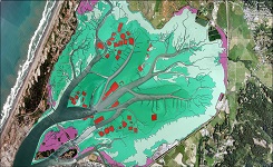
Data produced for the Florida Fish and Wildlife Conservation Commission's Florida Marine Research Institute (FMRI) in partnership with the South Florida Water Management District (SFWMD). This data set consists of digital data describing the seagrass, unvegetated bottom, open water, algal beds, oysters, and apparent shoreline for the Southwest Florida Seagrass project area,which consists of Pine Island Sound, Matlacha Pass, San Carlos Bay, the lower Caloosahatchee River, and Estero Bay, in 1999. The data set includes an ArcInfo coverage that was digitized from 1:24000 scale natural color aerial photographs that were photogrammetrically georeferenced utilizing GPS ground control points. Data was stereoscopically photointerpreted and digitized using a Zeiss P3 analytical stereoplotter. The seagrass beds and additional categories were classified according to the FDOT Florida Land Use, Cover and Forms Classification System (FLUCCS). Minimum mapping unit (mmu) for all classes was 0.25 acres. A Photointerpretation Key was developed to aid in the classification of collected data. Ground truthing was performed during the photointerpretation phase to ensure classification accuracy and consistency of PI. Digital files were created in Microstation design file format (.dgn). 1999 SWIM Seagrass data was translated from ARC/Info to .dgn format and was referenced as collateral tie information during the compilation process. These data were collected under a cooperative mapping program between the U.S. Geological Survey (USGS), the National Oceanic and Atmospheric Administration Office for Coastal Management (NOAA\OCM), and the Apalachicola National Estuarine Research Reserve (NERR). The primary objectives of this program were to collect marine geophysical data to develop a suite of seafloor maps to better define the extent of oyster habitats, the overall seafloor geology of the bay and provide updated information for management of this resource. In addition to their value for management of the bay's oyster resources, the maps also provide a geologic framework for scientific research and the public.
Original contact information:
Contact Org: NOAA Office for Coastal Management
Phone: 843-740-1202
Email: coastal.info@noaa.gov
Distribution Information
Controlled Theme Keywords
BENTHIC, COASTAL, environment, ESTUARY
Child Items
No Child Items for this record.
URLs
URL 1
| URL: | https://iocm.noaa.gov/cmecs |
|---|---|
| Name: | CMECS Home Page |
| URL Type: |
Online Resource
|
| Description: |
Information and resources on the CMECS standard and how to apply it |
URL 2
| URL: | http://www.cmecscatalog.org/ |
|---|---|
| Name: | CMECS Catalog |
| URL Type: |
Online Resource
|
| Description: |
Searchable online catalog of CMECS units, descriptions, and source references |
URL 3
| URL: | https://coast.noaa.gov/digitalcoast/ |
|---|---|
| Name: | NOAA's Office for Coastal Management (OCM) Digital Coast Data section |
| URL Type: |
Online Resource
|
| Description: |
The website provides not only coastal data, but also the tools, training, and information needed to make these data truly useful. Content comes from many sources, all of which are vetted by NOAA. |
URL 4
| URL: | https://coast.noaa.gov/ |
|---|---|
| Name: | NOAA's Office for Coastal Management (OCM) website |
| URL Type: |
Online Resource
|
| Description: |
Information on the NOAA Office for Coastal Management (OCM) |
URL 5
| URL: | https://coast.noaa.gov/data/Images/Collections/BenthicCover_thumbnail.jpg |
|---|---|
| Name: | Browse Graphic |
| URL Type: |
Browse Graphic
|
| File Resource Format: | JPEG |
| Description: |
Sample of benthic cover data |