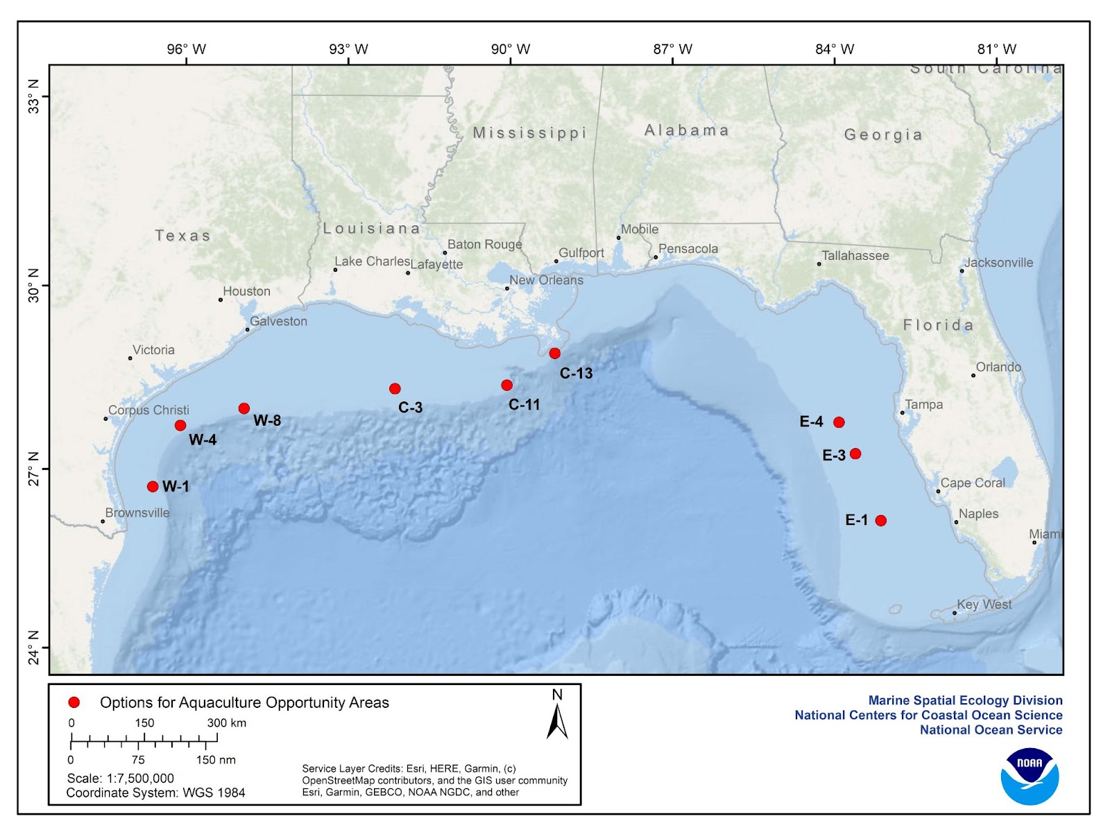
Map showing all nine potential location options, symbolized by red dots, for AOAs in federal waters in the Gulf of Mexico. Three locations, W-1, W-4 and W-8, are located off the coast of Texas. Three locations, C-3, C-11 and C-13, are located off the coast of Louisiana. Three locations, E-1, E-3 and E-4, are located off the west coast of Florida. This map can be found on pages vii and 133 of An Aquaculture Opportunity Atlas for the U.S. Gulf of Mexico.
Click on the map to enlarge
TEXAS
Option W-1

Click on the map to enlarge
Map of location W-1, depicted as a square situated approximately 35 nmi (65 km) east of the Port Mansfield Channel, Texas. W-1 is 2,000 acres and this map can be found on page 141 (Figure 3.31) of An Aquaculture Opportunity Atlas for the U.S. Gulf of Mexico.
TEXAS
Option W-4

Click on the map to enlarge
Map of location W-4, depicted as a square situated approximately 50 nmi (91.5 km) southeast of Port Aransas, Texas. W-4 is 2,000 acres and this map can be found on page 158 (Figure 3.43) of An Aquaculture Opportunity Atlas for the U.S. Gulf of Mexico.
TEXAS
Option W-8

Click on the map to enlarge
Map of location W-8, depicted as a square situated approximately 58 nmi (107.4 km) southeast of Freeport, Texas. W-4 is 500 acres and this map can be found on page 175 (Figure 3.55) of An Aquaculture Opportunity Atlas for the U.S. Gulf of Mexico.
LOUISIANA
Option C-3

Click on the map to enlarge
Map of location C-3, depicted as a square situated approximately 72 nmi (133.4 km) from Pecan Island (Morgan City, Louisiana, is the closest town with significant infrastructure). C-3 is 2,000 acres and this map can be found on page 194 (Figure 3.67) of An Aquaculture Opportunity Atlas for the U.S. Gulf of Mexico.
LOUISIANA
Option C-11

Click on the map to enlarge
Map of location C-11, depicted as a square situated approximately 41 nmi (76.7 km) south of Port Fourchon, Louisiana. C-11 is 2,000 acres and this map can be found on page 211 (Figure 3.79) of An Aquaculture Opportunity Atlas for the U.S. Gulf of Mexico.
LOUISIANA
Option C-13

Click on the map to enlarge
Map of location C-13, depicted as a square situated approximately 5 nmi (9.6 km) south of the inlet to South Pass, Louisiana. C-13 is 500 acres and this map can be found on page 228 (Figure 3.91) of An Aquaculture Opportunity Atlas for the U.S. Gulf of Mexico.
FLORIDA
Option E-1

Click on the map to enlarge
Map of location E-1, depicted as a square situated approximately 56 - 58 nmi (104 km – 107.7 km) from the inlets off of Fort Myers, Florida. E-1 is 500 acres and this map can be found on page 281 (Figure 3.128) of An Aquaculture Opportunity Atlas for the U.S. Gulf of Mexico.
FLORIDA
Option E-3

Click on the map to enlarge
Map of location E-3, depicted as a square situated approximately 49 nmi (91.6 km) to the inlet off Tampa, Florida. E-3 is 2,000 acres and this map can be found on page 264 (Figure 3.116) of An Aquaculture Opportunity Atlas for the U.S. Gulf of Mexico.
FLORIDA
Option E-4

Click on the map to enlarge
Map of location E-4, depicted as a square situated approximately 58 nmi (107.8 km) from the inlet in Clearwater, Florida. E-4 is 2,000 acres and this map can be found on page 247 (Figure 3.104) of An Aquaculture Opportunity Atlas for the U.S. Gulf of Mexico.
Cooperating Agencies
The U.S. Environmental Protection Agency, U.S. Army Corps of Engineers, Bureau of Ocean Energy Management, and U.S. Air Force will be cooperating agencies on this PEIS.
For More Information
Contact Andrew Richard, Southeast Regional Aquaculture Coordinator at nmfs.ser.aquaculture@noaa.gov or (727) 551-5709.
Individuals who use telecommunication devices for the deaf may call the Federal Information Relay Service at 800-877-8339 between 8 a.m. and 8 p.m., Eastern Time, Monday through Friday.
Federal Register Notices
Notice of Intent to Prepare PEIS