NATIONAL OCEANIC AND ATMOSPHERIC ADMINISTRATION
|
U.S. DEPARTMENT OF COMMERCE
Facebook
Instagram
Twitter
YouTube
Mail
|
SITE INDEX
CONTACT US
Close Promo Banner
Search NOAA Fisheries
Search
Menu
Find A Species
Find a Species
Dolphins & Porpoises
Fish & Sharks
Highly Migratory Species
Invertebrates
Sea Turtles
Seals & Sea Lions
Whales
Protected Species
All Threatened & Endangered Species
Marine Mammals
Species By Region
Alaska
New England/Mid-Atlantic
Pacific Islands
Southeast
West Coast
Helpful Resources
Marine Life Viewing Guidelines
Marine Life in Distress
Report a Stranded or Injured Marine Animal
Species in the Spotlight
Fishing & Seafood
Sustainable Fisheries
Bycatch
Catch Shares
Fishery Observers
Illegal, Unregulated, Unreported Fishing
Magnuson-Stevens Act
Research Surveys
Population Assessments
Resources for Fishing
Commercial Fishing
Recreational Fishing
Subsistence Fishing
Fishery Management Info
Permits & Forms
Rules & Regulations by Region
Sustainable Seafood
Seafood Profiles
Aquaculture
Commerce & Trade
Seafood Inspection
Related Topics
Atlantic Highly Migratory Species
Offshore Wind Energy
Cooperative Research
Enforcement
Financial Services
International Affairs
Science & Data
Socioeconomics
Protecting Marine Life
Endangered Species Conservation
Listing Species Under ESA
Critical Habitat
Consultations
Species Recovery
Research Surveys
Species in the Spotlight
Endangered Species Act
Marine Mammal Protection
Health & Stranding Response
Marine Mammal Protection Act
Research Surveys
Population Assessments
Take Reduction Plans
Marine Life in Distress
Report a Stranded or Injured Marine Animal
Bycatch
Ocean Acoustics/Noise
Unusual Mortality Events
Vessel Strikes
Related Topics
Marine Life Viewing Guidelines
Enforcement
Funding Opportunities
International Cooperation
Permits & Authorizations
Regulations & Actions
Offshore Wind Energy
Science & Data
Environment
Ecosystems
U.S. Regional Ecosystems
Management
Science
Habitat Conservation
Habitat Restoration
Habitat Protection
Types of Habitat
Habitat by Region
Science
Consultations
Climate Change
Understanding the Impacts
Responding to Change
Climate, Ecosystems & Fisheries Initiative
Regional Activities
Offshore Wind Energy
Regions
Our Regions
Alaska
New England/ Mid-Atlantic
Pacific Islands
Southeast
West Coast
Contact Us
Regional Offices
Science Centers
Resources & Services
Rules & Regulations
Fisheries Rules & Regs
Fisheries Management Info
Protected Resources Regs & Actions
Permits
Fishing & Seafood
Protected Resources
International & Trade
Funding & Financial Services
Funding Opportunities
Financial Services
Prescott Grants
Saltonstall-Kennedy Grants
Habitat Restoration Grants
Consultations
Habitat
Endangered Species
Tribal
Science & Data
Research
Surveys
Data
Maps & GIS
Publications
Published Research
Key Reports
Documents
Publication Databases
Outreach Materials
Laws & Policies
Magnuson-Stevens Act
Endangered Species Act
Marine Mammal Protection Act
Policies
Outreach & Education
For Educators
For Students
Educational Materials
Outreach Materials
Teacher at Sea
Events
About Us
NOAA Fisheries
Our Mission
Who We Are
Where We Work
Our History
News & Media
News & Announcements
Bulletins
Multimedia
Science Blogs
Events
Video Gallery
Photo Gallery
Careers & More
Career Paths
Inflation Reduction Act Opportunities
Internships
Volunteering and Citizen Science
Diversity & Inclusion
Contact Us
National Program Offices
Regional Offices
Science Centers
Our Partners
Regional Fishery Management Councils
Marine Fisheries Advisory Committee
American Fisheries Advisory Committee
Government Agencies
Non-Government Organizations
Inflation Reduction Act
Priority Investments
Recent Updates
Habitat Restoration
North Atlantic Right Whales
Pacific Salmon
Red Snapper
Search NOAA Fisheries
Search
Find A Species
Back
Find A Species
Find a Species
Dolphins & Porpoises
Fish & Sharks
Highly Migratory Species
Invertebrates
Sea Turtles
Seals & Sea Lions
Whales
Protected Species
All Threatened & Endangered Species
Marine Mammals
Species By Region
Alaska
New England/Mid-Atlantic
Pacific Islands
Southeast
West Coast
Helpful Resources
Marine Life Viewing Guidelines
Marine Life in Distress
Report a Stranded or Injured Marine Animal
Species in the Spotlight
Fishing & Seafood
Back
Fishing & Seafood
Sustainable Fisheries
Bycatch
Catch Shares
Fishery Observers
Illegal, Unregulated, Unreported Fishing
Magnuson-Stevens Act
Research Surveys
Population Assessments
Resources for Fishing
Commercial Fishing
Recreational Fishing
Subsistence Fishing
Fishery Management Info
Permits & Forms
Rules & Regulations by Region
Sustainable Seafood
Seafood Profiles
Aquaculture
Commerce & Trade
Seafood Inspection
Related Topics
Atlantic Highly Migratory Species
Offshore Wind Energy
Cooperative Research
Enforcement
Financial Services
International Affairs
Science & Data
Socioeconomics
Protecting Marine Life
Back
Protecting Marine Life
Endangered Species Conservation
Listing Species Under ESA
Critical Habitat
Consultations
Species Recovery
Research Surveys
Species in the Spotlight
Endangered Species Act
Marine Mammal Protection
Health & Stranding Response
Marine Mammal Protection Act
Research Surveys
Population Assessments
Take Reduction Plans
Marine Life in Distress
Report a Stranded or Injured Marine Animal
Bycatch
Ocean Acoustics/Noise
Unusual Mortality Events
Vessel Strikes
Related Topics
Marine Life Viewing Guidelines
Enforcement
Funding Opportunities
International Cooperation
Permits & Authorizations
Regulations & Actions
Offshore Wind Energy
Science & Data
Environment
Back
Environment
Ecosystems
U.S. Regional Ecosystems
Management
Science
Habitat Conservation
Habitat Restoration
Habitat Protection
Types of Habitat
Habitat by Region
Science
Consultations
Climate Change
Understanding the Impacts
Responding to Change
Climate, Ecosystems & Fisheries Initiative
Regional Activities
Offshore Wind Energy
Regions
Back
Regions
Our Regions
Alaska
New England/ Mid-Atlantic
Pacific Islands
Southeast
West Coast
Contact Us
Regional Offices
Science Centers
Resources & Services
Back
Resources & Services
Rules & Regulations
Fisheries Rules & Regs
Fisheries Management Info
Protected Resources Regs & Actions
Permits
Fishing & Seafood
Protected Resources
International & Trade
Funding & Financial Services
Funding Opportunities
Financial Services
Prescott Grants
Saltonstall-Kennedy Grants
Habitat Restoration Grants
Consultations
Habitat
Endangered Species
Tribal
Science & Data
Research
Surveys
Data
Maps & GIS
Publications
Published Research
Key Reports
Documents
Publication Databases
Outreach Materials
Laws & Policies
Magnuson-Stevens Act
Endangered Species Act
Marine Mammal Protection Act
Policies
Outreach & Education
For Educators
For Students
Educational Materials
Outreach Materials
Teacher at Sea
Events
About Us
Back
About Us
NOAA Fisheries
Our Mission
Who We Are
Where We Work
Our History
News & Media
News & Announcements
Bulletins
Multimedia
Science Blogs
Events
Video Gallery
Photo Gallery
Careers & More
Career Paths
Inflation Reduction Act Opportunities
Internships
Volunteering and Citizen Science
Diversity & Inclusion
Contact Us
National Program Offices
Regional Offices
Science Centers
Our Partners
Regional Fishery Management Councils
Marine Fisheries Advisory Committee
American Fisheries Advisory Committee
Government Agencies
Non-Government Organizations
Inflation Reduction Act
Priority Investments
Recent Updates
Habitat Restoration
North Atlantic Right Whales
Pacific Salmon
Red Snapper
Refine Results
Title
Region
Alaska
New England/Mid-Atlantic
Pacific Islands
Southeast
West Coast
National
International
Topic
Aquaculture
Atlantic Highly Migratory Species
Bycatch
Chesapeake Bay
Climate
Commercial Fishing
Ecosystems
Endangered Species Conservation
Enforcement
Fisheries Observers
Habitat Conservation
International Affairs
Marine Life in Distress
Marine Life Viewing Guidelines
Marine Mammal Protection
Offshore Wind Energy
Population Assessments
Recreational Fishing
Recreational Fishing Data
Seafood Commerce & Trade
Socioeconomics
Sustainable Fisheries
Sustainable Seafood
Species Category
Fish & Sharks
Corals & Invertebrates
Dolphins & Porpoises
Sea Turtles
Seals & Sea Lions
Whales
Other
Species
Sort By
Most Recent
Title, A to Z
Title, Z to A
Filter Results
Resources
Science & Data
All
Science Blogs
Research
Surveys
Data
Maps
All Science & Data
5
resources match your filter criteria.
Surprising Sights and Wondrous Wildlife in the Gulf of Maine
Field Fresh Blog: Science in Motion
Field Biologist Emma Fowler shares some of her favorite moments from the fall 2023 Cooperative Gulf of Maine Bottom Longline Survey.
January 03, 2024
-
Survey
,
New England/Mid-Atlantic
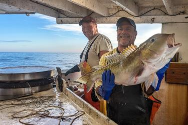
Captain Phil Lynch and mate Danny DeRose proudly displaying a golden tilefish they caught onboard the F/V Mary Elizabeth. Credit: NOAA Fisheries/Jacob Wilson
Every Day Is Different: An Observer's Perspective
Field Fresh Blog: Science in Motion
Fishery observing off Long Island, New York.
January 30, 2023
-
Fisheries Observer
,
New England/Mid-Atlantic
Sharks, Snapper, and Science—Kicking off the 27th Year of the Southeast Bottom Longline Survey
27th Year of the Southeast Bottom Longline Survey
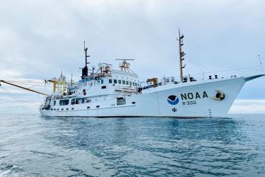
Bon voyage to the NOAA Ship Oregon II, its scientists, and crew beginning another year of the bottom longline survey. The 3-month survey will collect data on several species and their habitat.
August 24, 2022
-
Survey
,
Southeast
Since 1995 the bottom longline survey has been conducted on the Oregon II for shark and bony fish research. Credit: NOAA Office of Marine and Aviation Operations
Tilefish Management Unit
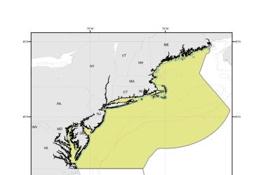
This dataset depicts the boundaries of the Tilefish Management Unit.
October 14, 2019
-
Map
,
New England/Mid-Atlantic
Tilefish Gear Restricted Areas
This dataset depicts the boundaries of the Tilefish Gear Restricted Areas.
October 14, 2019
-
Map
,
New England/Mid-Atlantic