Refine Results
Region
Management Areas
Map Type
Map Category
Topic
Species Category

Maps

656 resources match your filter criteria.

Groundfish Exclusion Areas

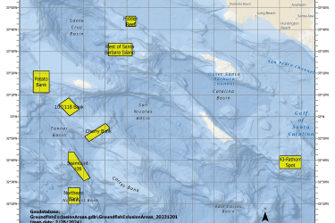
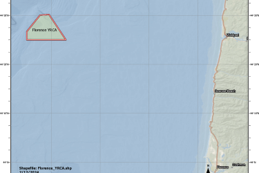
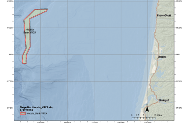
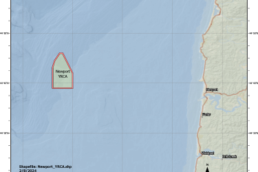
Groundfish Exclusion Areas (GEAs) are eight areas south of Point Conception, California intended to protect sensitive areas. These areas were reviewed and adopted by the Pacific Fishery Management Council in March 2023 under Alternative 3.
April 01, 2024 - Map ,
Map of Groundfish Exclusion Areas, California

Atlantic Sea Scallop Managed Waters Fishing Year 2024

This dataset depicts the boundaries of Sea Scallop Rotational Areas for 2024.
March 28, 2024 - Map ,
Scallop Map

Florence Yelloweye Rockfish Conservation Area

This dataset depicts the boundaries of the Florence Yelloweye Rockfish Conservation Area (YRCA) off central Oregon.
March 07, 2024 - Map ,
Map of Florence Yelloweye Rockfish Conservation Area

Heceta Bank Yelloweye Rockfish Conservation Area

This dataset depicts the boundaries of the Heceta Bank Yelloweye Rockfish Conservation Area (YRCA) off central Oregon.
March 07, 2024 - Map ,
Map of Heceta Bank Yelloweye Rockfish Conservation Area

Newport Yelloweye Rockfish Conservation Area

This dataset depicts the boundaries of the Newport Yelloweye Rockfish Conservation Area (YRCA) off central Oregon.
March 07, 2024 - Map ,
Map of the Newport Yelloweye Rockfish Conservation Area

Tillamook Yelloweye Rockfish Conservation Area

This dataset depicts the boundaries of the Tillamook Yelloweye Rockfish Conservation Area (YRCA) off northern Oregon.
March 07, 2024 - Map ,
Map showing Tillamook Yelloweye Rockfish Conservation Area

Nassau Grouper Critical Habitat Maps and GIS Data

Maps and GIS data representing critical habitat for the Nassau Grouper population.
December 21, 2023 - Map ,

The Southeast Region ESA Section 7 Mapper

We created an online application, the Section 7 Mapper, to assist federal action agencies in identifying the ESA-listed species and critical habitat in their project action area.
September 28, 2023 - Map ,

Monkfish Fishery Management Areas

Map depicting Monkfish Fishery Management Areas in the Greater Atlantic.
September 26, 2023 - Map ,
Monkfish_Fishery_Management_Areas_MAP.jpg

Summer Flounder Sea Turtle Protection Area Map and GIS Data

Map depicting where summer flounder trawlers in waters off Virginia (south of Cape Charles) and North Carolina must use an approved Turtle Excluder Device.
September 25, 2023 - Map ,
Summer_Flounder_Fishery-Sea_Turtle_Protection_Area_MAP.jpg