Refine Results
Region
Management Areas
Map Type
Map Category
Topic
Species Category

Maps

51 resources match your filter criteria.

Nassau Grouper Critical Habitat Maps and GIS Data

Maps and GIS data representing critical habitat for the Nassau Grouper population.
December 21, 2023 - Map ,

The Southeast Region ESA Section 7 Mapper

We created an online application, the Section 7 Mapper, to assist federal action agencies in identifying the ESA-listed species and critical habitat in their project action area.
September 28, 2023 - Map ,

Summer Flounder Sea Turtle Protection Area Map and GIS Data

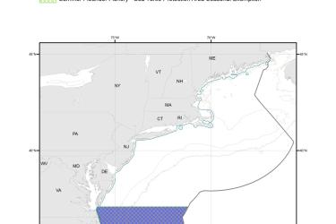
Map depicting where summer flounder trawlers in waters off Virginia (south of Cape Charles) and North Carolina must use an approved Turtle Excluder Device.
September 25, 2023 - Map ,
Summer_Flounder_Fishery-Sea_Turtle_Protection_Area_MAP.jpg

Rough Cactus Coral Critical Habitat Maps and GIS Data

Maps and GIS data representing critical habitat for the rough cactus coral.
August 08, 2023 - Map ,

Mountainous Star Coral Critical Habitat Maps and GIS Data

Maps and GIS data representing critical habitat for the mountainous star coral.
August 08, 2023 - Map ,

Lobed Star Coral Critical Habitat Maps and GIS Data

Maps and GIS data representing critical habitat for the lobed star coral.
August 08, 2023 - Map ,

Pillar Coral Critical Habitat Maps and GIS Data

Maps and GIS data representing critical habitat for the pillar coral.
August 08, 2023 - Map ,

Boulder Star Coral Critical Habitat Maps and GIS Data

Maps and GIS data representing critical habitat for the boulder star coral.
August 08, 2023 - Map ,

Sunflower Sea Star Fact Sheets

Sunflower sea stars are native to marine waters along the Pacific Coast, from northern Baja California to the central Aleutian Islands.
March 14, 2023 - Map ,

North Atlantic Right Whale Sightings

Interactive map of North Atlantic right whale sightings.
November 22, 2022 - Map ,
Group  of 4 North Atlantic right whales.