Refine Results
Region
Management Areas
Map Type
Map Category
Topic
Species Category

Maps

49 resources match your filter criteria.

2017-2023 Minke Whale Unusual Mortality Event along the Atlantic Coast Dead Animal Locations

This dataset represents dead animal locations associated with the 2017-2023 Minke Whale Unusual Mortality Event along the Atlantic Coast.
March 23, 2023 - Map ,

2016-2023 Humpback Unusual Mortality Event along the Atlantic Coast Dead Animal Locations

This dataset represents dead animal locations associated with the 2016-2023 Humpback Whale Unusual Mortality Event along the Atlantic Coast.
January 27, 2023 - Map ,

North Atlantic Right Whale Sightings

Interactive map of North Atlantic right whale sightings.
November 22, 2022 - Map ,
Group  of 4 North Atlantic right whales.

2022 Pinniped Unusual Mortality Event along the Maine Coast Dead Animal Locations

This dataset represents dead animal locations associated with the 2022 Pinniped Unusual Mortality Event along the Maine Coast.
August 17, 2022 - Map ,

Harbor Seals Pupping Timeframes Along the West Coast

Maps for California, Oregon, Washington and the Pacific Coast
April 20, 2022 - Map ,
Map of the West Coast showing habor seal pupping areas for February - April, March - May, March - June, mid-April - July, May - July, June - August, late-June - September, August - October

Map of Massachusetts Restricted Area Wedge for Trap/Pot Fishery (Emergency Rule)

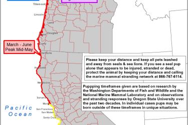
Fishermen must remove all trap/pot gear from this area and not set new gear in this area from February 1 to April 30, 2023. This restricted area was also in effect April 1-30, 2022.
February 28, 2022 - Map ,
Map of wedge closure area between MRA and MRA North

Maps for Proposed Time-Area Closures for Hawaiian Spinner Dolphins

Maps of the five proposed time-area closures at Kealakekua Bay, Hōnaunau Bay, Kauhakō Bay, Makako Bay, and La Perouse Bay.
December 03, 2021 - Map ,

Lobster/Jonah Crab Minimum Traps Per Trawl: Northeast Region

The trap/trawl minimums for the Northeast lobster and Jonah crab fishery by area.
October 06, 2021 - Map ,
Northeast Lobster and Jonah crab minimum traps per trawl map

Lobster/Jonah Crab Minimum Traps Per Trawl: LMA 2 and LMA 3

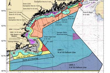
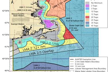
This map shows the minimum traps per trawl requirements for LMA 2 and LMA 3 put in place by the 2021 amendments to the Atlantic Large Whale Take Reduction Plan.
October 06, 2021 - Map ,
Minimum traps per trawl in LMA2 and LMA3