Refine Results
Region
Management Areas
Map Type
Map Category
Topic
Species Category

Maps

54 resources match your filter criteria.

Atlantic Sea Scallop Turtle Deflector Dredge Regulated Areas Map & GIS Data

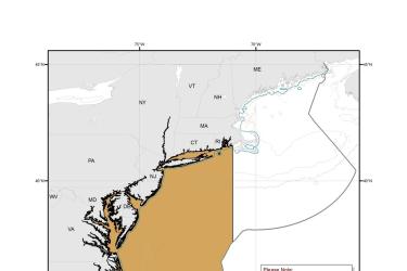
Map depicting where Turtle Deflector Dredges must be used when fishing for scallops in waters west of 71° W. long., from the shoreline to the outer boundary of the Exclusive Economic Zone, from May 1 through November 30.
August 27, 2019 - Map ,

Chain Mat-Modified Scallop Dredge Area Map & GIS Data

Map depicting where chain mats must be used when fishing for scallops in waters west of 71° W. long., from the shoreline to the outer boundary of the Exclusive Economic Zone, from May 1 through November 30.
August 27, 2019 - Map ,
Chain_Mat-Modified_Scallop_Dredge_Area_MAP.jpg

Species Ranges - Salmon and Steelhead (West Coast Region)

Maps and GIS data
August 22, 2019 - Map ,

Acropora: Elkhorn and Staghorn Coral Critical Habitat Map and GIS Data

Map and GIS data representing critical habitat for the conservation of threatened Acropora species in the Southeast U.S.
June 26, 2019 - Map ,
This is a map showing elkhorn and staghorn coral critical habitat in Florida and the Caribbean.

Atlantic Sturgeon Critical Habitat Map and GIS Data

Map and GIS data representing critical habitat for the conservation of endangered and threatened Atlantic sturgeon from Maine to Florida.
June 26, 2019 - Map ,
map-Atlantic-sturgeon-critical-habitat-GARFO-SERO.jpg

Green Turtle Critical Habitat Map and GIS Data

Map and GIS data representing critical habitat for the conservation of the threatened green turtle in the U.S. Caribbean.
June 26, 2019 - Map ,
map-green-turtle-critical-habitat-Caribbean-SERO.jpg

Gulf Sturgeon Critical Habitat Map and GIS Data

Map and GIS data representing critical habitat for the conservation of threatened Gulf sturgeon in the Southeast U.S.
June 26, 2019 - Map ,
map-Gulf-sturgeon-critical-habitat-SERO.jpg

Hawksbill Turtle Critical Habitat Map and GIS Data

Map and GIS data representing critical habitat for the conservation of endangered hawksbill turtles in the U.S. Caribbean.
June 26, 2019 - Map ,
map-hawksbill-turtle-critical-habitat-Caribbean-SERO.jpg

Leatherback Turtle Critical Habitat Map and GIS Data

Map and GIS data representing critical habitat for the conservation of endangered leatherback turtles.
June 26, 2019 - Map ,
map-leatherback-turtle-critical-habitat-Caribbean-SERO.jpg

Loggerhead Turtle – Northwest Atlantic Ocean DPS Critical Habitat Map

Loggerhead sea turtle critical habitat map and associated data files for the Northwest Atlantic Ocean DPS.
June 26, 2019 - Map ,