Refine Results
Region
Management Areas
Map Type
Map Category
Topic
Species Category

Maps

22 resources match your filter criteria.

Lobster/Jonah Crab Minimum Traps Per Trawl: Maine Zone F

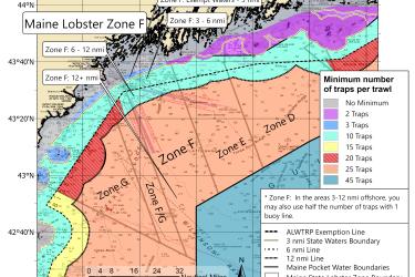
This map shows the new minimum traps per trawl requirements for Maine Zone F put in place by the 2021 amendments to the Atlantic Large Whale Take Reduction Plan.
October 06, 2021 - Map ,
Maine Zone F lobster traps per trawl minimum map

Lobster/Jonah Crab Minimum Traps Per Trawl: Maine Zone E

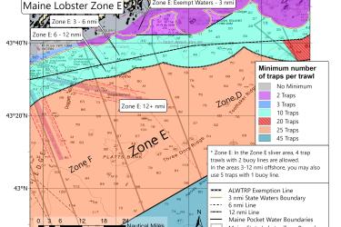
This map shows the new minimum traps per trawl requirements for Maine Zone E put in place by the 2021 amendments to the Atlantic Large Whale Take Reduction Plan.
October 06, 2021 - Map ,
Maine Zone F lobster traps per trawl minimum map

Lobster/Jonah Crab Minimum Traps Per Trawl: Maine Zone D

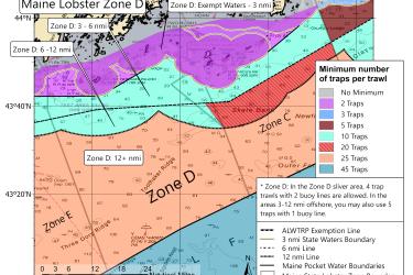
This map shows the new minimum traps per trawl requirements for Maine Zone D put in place by the 2021 amendments to the Atlantic Large Whale Take Reduction Plan.
October 06, 2021 - Map ,
Maine Zone D lobster traps per trawl minimum map

Lobster/Jonah Crab Minimum Traps Per Trawl: Maine Zone C

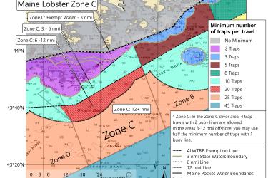
This map shows the new minimum traps per trawl requirements for Maine Zone C put in place by the 2021 amendments to the Atlantic Large Whale Take Reduction Plan.
October 06, 2021 - Map ,
Maine Zone C lobster traps per trawl minimum map

Lobster/Jonah Crab Minimum Traps Per Trawl: Maine Zone B

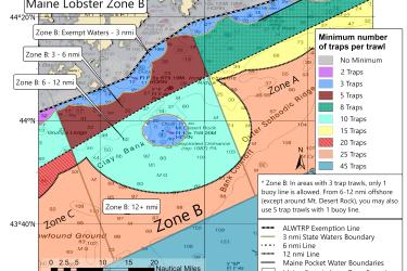
This map shows the new minimum traps per trawl requirements for Maine Zone B put in place by the 2021 amendments to the Atlantic Large Whale Take Reduction Plan.
October 06, 2021 - Map ,
Maine Zone B lobster traps per trawl minimum map

Lobster/Jonah Crab Minimum Traps Per Trawl: Maine Zone A

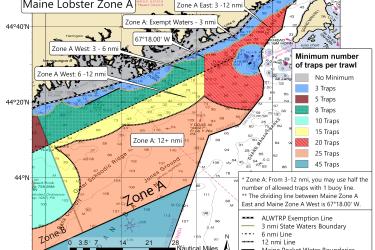
This map shows the new minimum traps per trawl requirements for Maine Zone A put in place by the 2021 amendments to the Atlantic Large Whale Take Reduction Plan.
October 06, 2021 - Map ,
Maine Zone A lobster traps per trawl minimum map

New and Existing Restricted Areas: 2021 Atlantic Large Whale Take Reduction Plan Modifications

Two new restricted areas were added in the 2021 amendments to the Atlantic Large Whale Take Reduction Plan, and two others were modified.
October 05, 2021 - Map ,
New and old restricted areas for lobster and Jonah crab trap pot fishermen

Humpback Whale Critical Habitat Maps and GIS Data

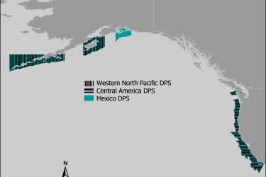
Maps and GIS data representing critical habitat for the Western North Pacific distinct population segment (DPS), the Central America DPS, and the Mexico DPS of humpback whales.
April 21, 2021 - Map ,
Humpback Whale Critical Habitat

Other Southeast Gillnet Waters

This dataset depicts the boundaries of the Other Southeast Gillnet Waters.
October 12, 2019 - Map ,
Other-Southeast-Gillnet-Waters-MAP-NOAA-GARFO.jpg

Exempted Waters for Maine State Lobster Permits

Map and GIS data representing the exempted waters for Maine State American lobster permits, also known as "Maine Pocket Waters."
August 28, 2019 - Map ,