Refine Results
Region
Management Areas
Map Type
Map Category
Topic
Species Category

Maps

4 resources match your filter criteria.

Atlantic Sturgeon Critical Habitat Map and GIS Data

Map and GIS data representing critical habitat for the conservation of endangered and threatened Atlantic sturgeon from Maine to Florida.
June 26, 2019 - Map ,
map-Atlantic-sturgeon-critical-habitat-GARFO-SERO.jpg

Loggerhead Turtle – Northwest Atlantic Ocean DPS Critical Habitat Map

Loggerhead sea turtle critical habitat map and associated data files for the Northwest Atlantic Ocean DPS.
June 26, 2019 - Map ,

North Atlantic Right Whale Critical Habitat Map and GIS Data

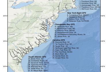
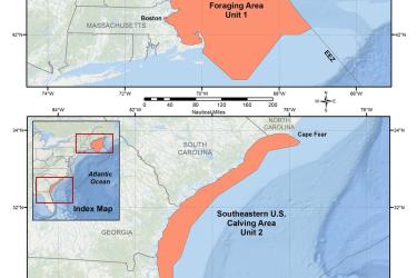
Map and GIS data representing critical habitat for the conservation of endangered North Atlantic right whale in the Greater Atlantic and Southeast Regions.
June 25, 2019 - Map ,
map-North-Atlantic-right-whale-critical-habitat-GARFO-SERO.jpg

Atlantic Salmon Gulf of Maine DPS Critical Habitat Map and GIS Data

Critical habitat is habitat needed to support recovery of listed species. When a species is listed under the Endangered Species Act, NOAA Fisheries is required to determine whether there are areas that meet the definition of critical habitat.
June 19, 2009 - Map ,