Refine Results
Topic
Species Category
Region

Gulf of Mexico Fisheries Management Map Results

21 results match your filter criteria.

Shrimp & Stone Crab Separation Zones Fishery Management Areas Map & GIS Data

Map and GIS data representing shrimp and stone crab separation zones fishery management areas in the Gulf of Mexico.
June 25, 2019 - Map ,
shrimpcrab.jpg

West and East Flower Garden Banks HAPC Fishery Management Area Map & GIS data

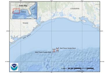
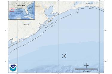
Map and GIS data representing West and East Flower Garden Banks Habitat Areas of Particular Concern (HAPC) fishery management areas to protect Gulf of Mexico corals.
June 25, 2019 - Map ,
flowergardenshapc.jpg

Florida Middle Grounds HAPC Fishery Management Area Map & GIS Data

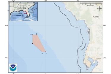
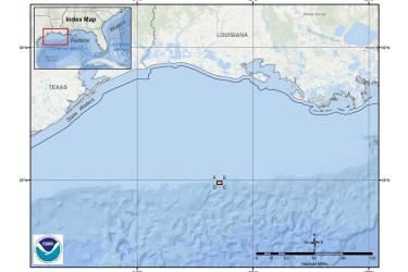
Map and GIS data representing Florida Middle Grounds Habitat Area of Particular Concern (HAPC) fishery management area to protect Gulf of Mexico corals.
June 25, 2019 - Map ,
middle_grounds.jpg

Tortugas Marine Reserves HAPC Fishery Management Area Map & GIS Data

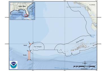
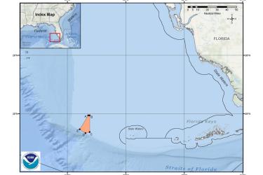
Map and GIS data representing the Tortugas Marine Reserves Habitat Area of Particular Concern (HAPC) fishery management area to protect Gulf of Mexico corals.
June 25, 2019 - Map ,
tortugashapc.jpg

Pulley Ridge Habitat Area of Particular Concern (HAPC) Fishery Management Area Map & GIS Data

Map and GIS data representing Pulley Ridge HAPC fishery management area to protect Gulf of Mexico corals.
June 24, 2019 - Map ,
pulleyridgehapc.jpg

Stetson Bank Habitat Area of Particular Concern (HAPC) Fishery Management Area Map & GIS data

Map and GIS data representing Stetson Bank HAPC fishery management area to protect Gulf of Mexico corals.
June 24, 2019 - Map ,
stetsonbankhapc.jpg

McGrail Bank Habitat Area of Particular Concern (HAPC) Fishery Management Area Map & GIS data

Map and GIS data representing McGrail Bank HAPC fishery management area to protect Gulf of Mexico corals.
June 24, 2019 - Map ,
mcgrailbankhapc.jpg

King Mackerel Migratory Group Zones Fishery Management Areas Map & GIS Data

Map and GIS data representing king mackerel coastal migratory pelagic group zones in the Gulf of Mexico, South Atlantic, and Mid-Atlantic.
June 24, 2019 - Map ,
king_mackerel.jpg

Spanish Mackerel Migratory Group Zones Fishery Management Areas Map & GIS Data

Map and GIS data representing Spanish mackerel coastal migratory pelagic group zones in the Gulf of Mexico, South Atlantic, and Mid-Atlantic.
June 24, 2019 - Map ,
spanish_mackerel.jpg

Cobia Migratory Group Zones Fishery Management Areas Map & GIS Data

Map and GIS data representing cobia coastal migratory pelagic group zones in the Gulf of Mexico, South Atlantic, and Mid-Atlantic.
June 24, 2019 - Map ,
This is a map of cobia migratory group zones in the Gulf of Mexico and South Atlantic Region.