Refine Results
Topic
Species Category
Region

ShoreZone Results

27 results match your filter criteria.

ShoreZone Ground Stations Metadata

The web-posted Alaska Shore Station Database is a compilation of hundreds of intertidal sites that were visited and evaluated throughout the coastal waters of Alaska. At each station attempts are made to document all observed species and their assemblages, geomorphic features, measurements of beach length and slope, and gather photographic examples. This online database has been designed to integrate with the spatially explicit, Alaska ShoreZone web enabled GIS platform. The end result is a user friendly and accessible version of the Shore Station database with a queryable display of station locations, downloadable species lists and photos.
September 14, 2018 - Data Set ,

ShoreZone Program Daily Log - July 15, 2018

Alaska ShoreZone Program - Aerial Imaging Surveys in Glacier Bay National Park and Preserve.
Map showing changes to landscape

ShoreZone Program Daily Log - July 14, 2018

Alaska ShoreZone Program - Aerial Imaging Surveys in Glacier Bay National Park and Preserve.
Aerial image of coast in Alaska with mountains in the background

ShoreZone Program Daily Log - July 11, 2018

Aerial Imaging Surveys in Glacier Bay National Park and Preserve.
Map showing imaging from shorezone

ShoreZone Program Daily Log - July 13, 2018

Day number three and mother nature was smiling sunshine. Although this makes for prime flying conditions it actually is not good lighting for imaging. Sunlight can reflect on the surface of the water and create a blinding reflection when you are shooting down from a helicopter flying at several hundred feet. The extreme contrast in lighting can send the camera’s light meters into a tailspin resulting in under and over exposed photos. Imaging glaciers on a sunny day is also challenging for the same reasons, nothing like a giant piece of ice to reflect sunlight and wash out a photo. While flying we must always be aware of what angle the sunlight is at and where it will be as we wind around tight corners and move under the shadows of steep mountain faces following the contour of complex shorelines. Sometimes there's just no avoiding getting photobombed by the sun. The ideal conditions for imaging the coastal zone are no wind, light cloud cover with a high ceiling (several thousand feet), and no rain. A show stopper for the imaging team is when the fog monster shows up.
Aerial view of Barlett Cove in Glacier Bay, Alaska.

ShoreZone Coastal Habitat Surveys Continue in Alaska

Alaska ShoreZone Program - Aerial Imaging Surveys in Glacier Bay National Park and Preserve.
July 13, 2018 - Feature Story ,
Aerial view of a coast with water and trees

ShoreZone Program Daily Log - July 12, 2018

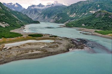
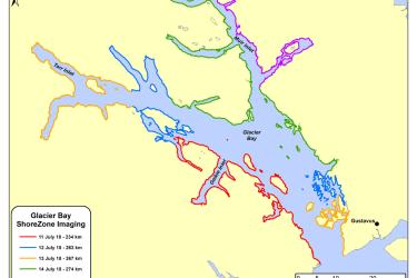
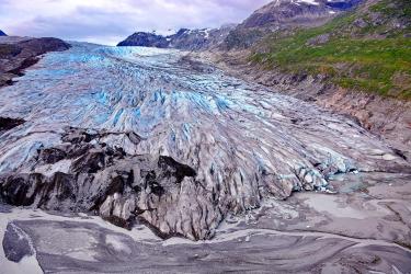
We have successfully completed Day 2 of surveying Glacier Bay National Park for some of the northern headlands in the bay. Today’s survey included imaging of Reid Glacier (see image below), the first of many tidewater glaciers to come. So far, the flight crew has been able to generally stick to their flight plan. Glacier Bay National Park & Preserve 2018 facts (National Park Service): Two hundred and fifty years ago a single, large tidewater glacier covered all of Glacier Bay. By 1750 the glacier began to retreat and has now retreated 60 miles to the head of the bay. At last count there were 1, 045 glaciers in the Park. There are over 50 named glaciers, seven of which are active tidewater glaciers that calve icebergs into the sea. In general, tidewater and terrestrial glaciers in the Park have been thinning and receding over the last several decades. Exceptions include the Johns Hopkins and Margerie glaciers.
Glacier with green hills and mountains in background

Nearshore Fish Photos

Photo catalog of fish species in nearshore waters of Alaska.

ShoreZone - Maps, Video, Images

Images, videos and maps of Alaska's coastline. The high resolution, attribute rich dataset is a useful tool for extrapolation of site data over broad spatial ranges for creating a variety of habitat models and oil spill response tools.
April 30, 2018 - Query Tool ,
shorezone-ak-coastline1217.png

ShoreZone Survey Flight Logs and Regional Summary Reports

Read up on these logs and reports detailing video imaging surveys done in Alaska.