Refine Results
Topic
Species Category
Region

South Atlantic Fisheries Management Map Results

29 results match your filter criteria.

South Atlantic Shrimp Cold Weather Closure Fishery Management Area Map & GIS Data

Map and GIS data representing the South Atlantic shrimp cold weather closure.
June 27, 2019 - Map ,
SA_shrimp_cold.jpg

Allowable Octocoral Closed Area Fishery Management Area Map & GIS Data

Map and GIS data representing the allowable octocoral closed area to protect South Atlantic corals.
June 27, 2019 - Map ,
octocoral.jpg

Oculina Bank HAPC and Experimental Closed Area Fishery Management Area Map & GIS Data

Map and GIS data representing the Oculina Bank Habitat Areas of Particular Concern (HAPC) and experimental closed area in the South Atlantic Region.
June 27, 2019 - Map ,
OculinaBank.jpg

Cape Lookout Lophelia Banks Deepwater Coral HAPC Fishery Management Area Map & GIS Data

Map and GIS data representing the Cape Lookout Lophelia Banks Deepwater Coral Habitat Areas of Particular Concern (HAPC) in the South Atlantic Region.
June 27, 2019 - Map ,
CapeLookout.jpg

Cape Fear Lophelia Banks Deepwater Coral HAPC Fishery Management Area Map & GIS Data

Map and GIS data representing the Cape Fear Lophelia Banks Deepwater Coral Habitat Areas of Particular Concern (HAPC) in the South Atlantic Region.
June 27, 2019 - Map ,
CapeFear.jpg

Stetson-Miami Terrace Deepwater Coral HAPC Fishery Management Area Map & GIS Data

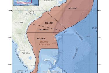
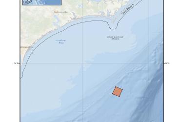
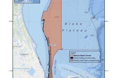
Map and GIS data representing the Stetson Reefs, Savannah and East Florida Lithotherms, and Miami Terrace (Stetson-Miami Terrace) Deepwater Coral Habitat Areas of Particular Concern (HAPC) in the South Atlantic Region.
June 27, 2019 - Map ,
Stetson_Miami.jpg

Pourtales Terrace Deepwater Coral HAPC Fishery Management Area Map & GIS Data

Map and GIS data representing the Pourtales Terrace Deepwater Coral Habitat Areas of Particular Concern (HAPC) in the South Atlantic Region.
June 27, 2019 - Map ,
Pourtales.jpg

Blake Ridge Diapir Deepwater Coral HAPC Fishery Management Area Map & GIS Data

Map and GIS data representing the Blake Ridge Diapir Deepwater Coral Habitat Areas of Particular Concern (HAPC) in the South Atlantic Region.
June 27, 2019 - Map ,
BlakeRidge.jpg

Shrimp Fishery Access Areas Fishery Management Areas Map & GIS Data

Map and GIS data representing shrimp fishery access areas in portions of the Stetson-Miami Terrace Deepwater Coral HAPC in the South Atlantic Region.
June 27, 2019 - Map ,
shrimp_AA.jpg

Golden Crab Fishery Access Areas Fishery Management Areas Map & GIS Data

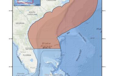
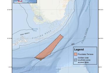
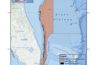
Map and GIS data representing golden crab fishery access areas in portions of the Stetson-Miami Terrace and the Pourtales Terrace Deepwater Coral HAPCs in the South Atlantic Region.
June 27, 2019 - Map ,
GoldenCrab_AA.jpg