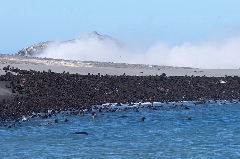
In August 2023, marine mammal biologists from the Alaska Fisheries Science Center returned to Bogoslof Island for the first time in 4 years. Bogoslof is home to one of the three northern fur seal breeding colonies in Alaska that together comprise the Eastern Pacific stock. This expedition was part of a routine survey, part of our efforts to estimate the northern fur seal population.
The Bogoslof population is relatively new—fur seals started breeding here in 1980. Remarkably, those initial animals have exploded into the tens of thousands. This is a welcome contrast to the overall decline witnessed at the Pribilof Islands rookeries. However, the 2019 Bogoslof survey was preceded by volcanic eruptions, which yields a fascinating case study. How do tens of thousands of northern fur seals react to drastic changes to their summertime home?
Bogoslof’s Eruption Timeline
Bogoslof is the tip of a 6,000-foot underwater volcano, which lies 61 miles northwest of Unalaska Island in the Aleutian Chain. It erupted out of the sea in 1796. In 1883, another major eruption produced Fire Island, a rocky spire just to the north.


Over the following 40 years, new peaks came and went. Eruptions formed land bridges between Bogoslof and Fire Island that exploded or eroded away over time. In 1927 and 1992, two new prominent domes formed, which still border the northern shore. Outside of the 18-day eruption that formed the 1992 dome, Bogoslof enjoyed decades of relative stability from 1927 to 2016. The island measured about three-quarters of a mile long and a quarter-mile wide.

Tundra grass, putchki (wild celery), and wildflowers colonized the land, likely brought by migrating birds. Tens of thousands of puffins, kittiwakes, and murres established nesting colonies, and Steller sea lions dotted the shoreline. More recently, in 1980, northern fur seals established a new rookery and the population took off. Fast forward a few decades and Bogoslof completely changed.


Starting in December of 2016, 70 explosive events over the course of 9 months rocked Bogoslof and sent a mile-high stream of ash and smoke into the sky. Air travel was disrupted to and from Dutch Harbor—our nation’s largest fishing port by volume. When the dust settled, the island was three times larger and there was not a blade of grass in sight. The entire island’s surface was made up of new rock, ash, a smoking mountain, and bubbling pools.


Since 2017, Bogoslof has been continually smoking. Over the past couple of years, winter storms have pounded the shoreline, eroding away much of the perimeter. Today, the island’s size is closer to its pre-2016 eruption state, but constantly changing. Signs of unrest continue, with more than 100 earthquakes recorded in October 2023. Eruption may not be imminent, but volcanologists are keeping a close eye.

Fur Seals Trends in the Eastern Pacific
The Alaska Fisheries Science Center’s Marine Mammal Lab monitors northern fur seal populations in the United States. Specifically, we track the Eastern Pacific and California stocks. They breed on the Pribilof Islands and Bogoslof Island in Alaska, and on San Miguel Island and South Farallon Island in California. Population estimates are derived from pup production; current methods began in the 1960s. This and other long-term data series are critical for understanding population trends.

In the Eastern Pacific stock, the overall population has been dropping, due to a 3.2 percent per year decline on the Pribilof Islands. Since 2018, there have been fewer than 100,000 pups born annually on the two main Pribilof islands of St. Paul and St. George—less than half from just 20 years earlier. But Bogoslof has been a shining star. The population increased sevenfold in the same time frame, at a rate of 9.2 percent per year.

During 2016 and 2017, Bogoslof was erupting and the landscape completely changed. Did this impact the fur seal growth?
Continue reading in part 2 tomorrow, which focuses on how our scientists track the fur seal population on Bogoslof and the effects of the recent eruptions and subsequent erosion. It also looks at the importance of this breeding colony to the overall health of the Eastern Pacific stock.