Pacific Reef Assessment and Monitoring Program: Rapid Ecological Assessment Quadrat Surveys of Corals around the Marianas Islands from 2003 to 2007
Data Set (DS) | Pacific Islands Fisheries Science Center (PIFSC)GUID: gov.noaa.nmfs.inport:24527 | Updated: May 15, 2025 | Published / External
Summary
Short Citation
Pacific Islands Fisheries Science Center, 2025: Pacific Reef Assessment and Monitoring Program: Rapid Ecological Assessment Quadrat Surveys of Corals around the Marianas Islands from 2003 to 2007, https://www.fisheries.noaa.gov/inport/item/24527.
Full Citation Examples
The Pacific Reef Assessment and Monitoring Program (Pacific RAMP), established by the Coral Reef Ecosystem Program (CREP) of the NOAA Pacific Islands Fisheries Science Center (PIFSC), is tasked with documenting and understanding the status and trends of coral reef ecosystems in the U.S. Pacific. Pacific RAMP involves an interdisciplinary series of integrated ecosystem observations of coral reefs around ~ 50 islands, atolls, and shallow-water banks of the Mariana Archipelago, American Samoa, the Hawaiian Archipelago, and the Pacific Remote Islands Marine National Monument. Pacific RAMP surveys are designed to characterize the spatial and temporal variability of the distribution, abundance, and diversity of corals, algae, other macro-invertebrates, and fishes in the context of their benthic habitats and oceanographic environments.
As part of this Pacific-wide monitoring effort, CRED conducted its first Pacific RAMP research cruise to the Mariana Archipelago (MARAMP) in 2003, with subsequent cruises to follow on a biennial cycle through 2011, and on a triennial cycle thereafter when Pacific RAMP was implemented as part of NOAA's National Coral Reef Monitoring Program (NCRMP).
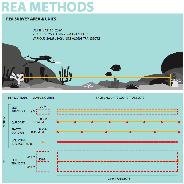
The coral data described herein were collected via Rapid Ecological Assessment (REA) surveys following the quadrat method, and conducted at specific reef sites around the islands and reefs of Guam and the Commonwealth of the Northern Mariana Islands (CNMI) during MARAMP 2003, 2005, and 2007. During MARAMP 2003, 2005, and 2007, the majority of REA surveys were conducted along the fore reef slopes of islands at depths of 10-20 m; however, other habitat types were also surveyed. During REA surveys, biological assessment teams---a fish team, a coral team, and a combined algal and macro-invertebrate team---followed highly structured protocols that were repeated at each REA site. REA sites were selected in 2003 and, when possible, revisited during 2005 and 2007; a few additional sites were added in 2005 and 2007, and were chosen based on consultations with the resource management agencies of each jurisdiction.
Quadrat surveys were conducted at all islands surveyed during MARAMP 2003, all but one island during MARAMP 2005, and at 10 of 15 islands during MARAMP 2007. The quadrat method was only employed during surveys in the Mariana Archipelago, and the method was retired from Pacific RAMP following MARAMP 2007.
The quadrat survey data include species/genus identification of individual coral colonies and empirical size measurements (colony length and width) that can provide metrics such as generic richness and composition, coral-colony density, and size distribution (not included in the dataset), and can be accessed online via the NOAA National Centers for Environmental Information (NCEI) Ocean Archive, accession #0129066.
Distribution Information
-
PDF - Adobe Portable Document Format, 34 mb
'Chapter 2: Methods & Operational Background' of the "Coral Reef Ecosystem Monitoring Report of the Mariana Archipelago: 2003-2007":
Brainard RE, Asher J, Blyth-Skyrme V, Coccagna EF, Dennis K, Donovan MK, Gove JM, Kenyon J, Looney EE, Miller JE, Timmers MA, Vargas-ÃÂngel B, Vroom PS, Vetter O, Zgliczynski B, Acoba T, DesRochers A, Dunlap MJ, Franklin EC, Fisher-Pool PI, Braun CL, Richards BL, Schopmeyer SA, Schroeder RE, Toperoff A, Weijerman M, Williams I, Withall RD (2012) Coral reef ecosystem monitoring report of the Mariana Archipelago: 2003– 2007. NOAA Fisheries, Pacific Islands Fisheries Science Center, PIFSC Special Publication, SP-12-01, 1019 p.
-
CSV - Comma Separated Values (Text), 6.51 mb
The "Pacific RAMP Quadrat Surveys of Corals" data package archived at the NOAA National Centers for Environmental Information (NCEI) Ocean Archive includes observations from quadrat surveys of corals by the NOAA Coral Reef Ecosystem Program conducted at various islands in the Mariana Archipelago between 2003 and 2007, and the documentation describing the field methodologies. NOAA NCEI Accession #0129066.
None
Please cite NOAA Coral Reef Ecosystem Program (CREP) when using the data.
Example
Cite as: Vargas-Ángel, Bernardo; Coral Reef Ecosystem Program; Pacific Islands Fisheries Science Center (2015). Pacific Reef Assessment and Monitoring Program: Rapid Ecological Assessment Quadrat Surveys of Corals around the Marianas Islands from 2003 to 2007 (NCEI Accession 0129066). NOAA National Centers for Environmental Information. Unpublished Dataset. [access date]
Controlled Theme Keywords
biota
Child Items
| Type | Title |
|---|---|
| Entity | View: V0_CORAL_OBS_QUAD |
URLs
URL 1
| URL: | https://www.pifsc.noaa.gov/cred/coral_reef_ecosystem_monitoring_reports.php |
|---|---|
| URL Type: |
Online Resource
|
| File Resource Format: | |
| Description: |
Coral reef ecosystem monitoring report of the Mariana Archipelago: 2003 - 2007. Chapter 2: Methods and Operational Background, provides a comprehensive review of the benthic monitoring methods employed in the Marianas from 2003-2007. |
URL 2
| URL: | https://www.pifsc.noaa.gov/library/pubs/SP-10-002.pdf |
|---|---|
| URL Type: |
Online Resource
|
| File Resource Format: | |
| Description: |
Coral reef ecosystems of the Mariana Archipelago: a 2003 - 2007 overview. |
URL 3
| URL: | https://www.pifsc.noaa.gov/library/pubs/cruise/Sette/CR0307-REB.pdf |
|---|---|
| URL Type: |
Online Resource
|
| File Resource Format: | |
| Description: |
MARAMP 2003, NOAA Ship Oscar Elton Sette Cruise Report. Oscar E. Sette, Cruise 03-07. Coral Reef Ecosystem Research 19 Aug - 30 Sep 2003. Commonwealth of the Mariana Islands and Guam. |
URL 4
| URL: | https://www.pifsc.noaa.gov/library/pubs/cruise/Sette/CR051011-1.RES.pdf |
|---|---|
| URL Type: |
Online Resource
|
| File Resource Format: | |
| Description: |
MARAMP 2005, NOAA Ship Oscar Elton Sette Cruise Report. Oscar E. Sette, Cruise 05-10 and 05-11. Coral Reef Ecosystem Assessment and Research 16 Aug - 1 Oct 2005. Marianas Archipelago: (Saipan Guguan, Pagan, Asuncion, Uracas, Maug, Supply Reef, Agrihan, Alamagan, Zelandia Bank Sarigan, Anatahan, Pathfinder, Arakane, Tinian, Aguijan, and Rota). |
URL 5
| URL: | https://www.pifsc.noaa.gov/library/pubs/cruise/Sette/CR0512-1.RES.pdf |
|---|---|
| URL Type: |
Online Resource
|
| File Resource Format: | |
| Description: |
MARAMP 2005, NOAA Ship Oscar Elton Sette Cruise Report. Oscar E. Sette, Cruise 05-12. Coral Reef Ecosystem Assessment and Research, 3-9 Oct 2005. Marianas Archipelago: (Island of Guam, Santa Rosa Reef, and Galvez Bank). |
URL 6
| URL: | https://www.pifsc.noaa.gov/library/pubs/cruise/Hiialakai/CRHI0703-RS.pdf |
|---|---|
| URL Type: |
Online Resource
|
| File Resource Format: | |
| Description: |
MARAMP 2007, NOAA Ship Hi‘ialakai Cruise Report. Hi‘ialakai, Cruise 07-03. Coral Reef Ecosystem Research 25 May - 9 June 2007. Commonwealth of the Northern Marianas Islands: Anatahan, Sarigan, Zealandia Bank, Guguan, Alamagan, Paga, Agrihan, Asuncion, Maug, Supply Reef, Uracas (or Farallon de Pajaros). |
URL 7
| URL: | https://data.nodc.noaa.gov/coris/data/NOAA/nmfs/pifsc/cred/coral_quadrat/BrowseGraphic_CoralQuadrat.png |
|---|---|
| URL Type: |
Browse Graphic
|
| File Resource Format: | PNG |
| Description: |
Browse graphic. |
Child Items
Rubric scores updated every 15m
| Type | Title |
|---|---|
| Entity | View: V0_CORAL_OBS_QUAD |