Search Help Show/Hide Menu
Summary
Item Identification
Keywords
Physical Location
Data Set Info
Support Roles
Extents
Spatial Info
Access Info
Distribution Info
URLs
Activity Log
Tech Environment
Data Quality
Lineage
Child Items
Catalog Details

Summary

Channel Islands National Marine Sanctuary Locator Map

Short Citation
Office of National Marine Sanctuaries, 2026: Channel Islands National Marine Sanctuary Boundary (polygons), https://www.fisheries.noaa.gov/inport/item/40040.
Full Citation Examples
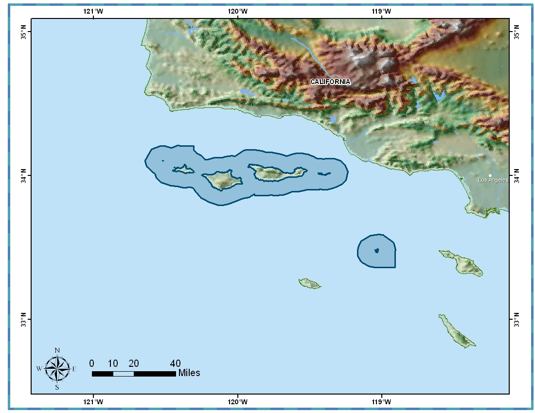
Abstract

NOAA's Office of National Marine Sanctuaries serves as the trustee for a national network of underwater parks encompassing both marine and Great Lakes waters from Washington state to the Florida Keys, and from Lake Huron to American Samoa. The network includes a system of national marine sanctuaries and marine national monuments. Few places on the planet can compete with the diversity of the National Marine Sanctuary System, which protects America's most iconic undersea natural and cultural resources. The system works with diverse partners and stakeholders to promote responsible, sustainable ocean uses that ensure the health of our most valued ocean and Great Lake places. By investing in innovative solutions, we strengthen these iconic places to address 21st-century challenges while supporting America's commerce and tourism. These unique locations inspire people to visit, value, and steward our nation's iconic ocean and Great Lakes places.

Purpose

The legal boundaries of the national marine sanctuaries are defined within the Code of Federal Regulations, at 15 C.F.R. Part 922 and the subparts therein. The GIS compatible digital boundary files for each national marine sanctuary are representations of those legal boundaries and are based on the best available data.

These files are provided to promote an understanding of the boundaries, locations, and extents for each national marine sanctuary. They are based on the legal definition of each sanctuary as defined in the Code of Federal Regulations, at 15C.F.R. Part 922 and the subparts therein as stressed previously. These digital files are not intended and should not be relied upon for use in navigation or for legal purposes. For legal questions relating to the digital boundary files, please contact NOAA's Office of National Marine Sanctuaries at the information provided in this metadata record.

Data Access & Downloads

Access Constraints:

None

Use Constraints:

NOT FOR LEGAL USE

Controlled Theme Keywords

boundaries

Contact Information

Point of Contact
GIS Coordinator
sanctuaries@noaa.gov
(301) 713-3125

Metadata Contact
GIS Coordinator
sanctuaries@noaa.gov
(301) 713-3125

Extents

Geographic Area 1

-120.64208° W, -118.90712° E, 34.20707° N, 33.36241° S

Time Frame 1
2008

Item Identification

Title: Channel Islands National Marine Sanctuary Boundary (polygons)
Short Name: cinms_py
Status: Completed
Publication Date: 2008-06
Abstract:

NOAA's Office of National Marine Sanctuaries serves as the trustee for a national network of underwater parks encompassing both marine and Great Lakes waters from Washington state to the Florida Keys, and from Lake Huron to American Samoa. The network includes a system of national marine sanctuaries and marine national monuments. Few places on the planet can compete with the diversity of the National Marine Sanctuary System, which protects America's most iconic undersea natural and cultural resources. The system works with diverse partners and stakeholders to promote responsible, sustainable ocean uses that ensure the health of our most valued ocean and Great Lake places. By investing in innovative solutions, we strengthen these iconic places to address 21st-century challenges while supporting America's commerce and tourism. These unique locations inspire people to visit, value, and steward our nation's iconic ocean and Great Lakes places.

Purpose:

The legal boundaries of the national marine sanctuaries are defined within the Code of Federal Regulations, at 15 C.F.R. Part 922 and the subparts therein. The GIS compatible digital boundary files for each national marine sanctuary are representations of those legal boundaries and are based on the best available data.

These files are provided to promote an understanding of the boundaries, locations, and extents for each national marine sanctuary. They are based on the legal definition of each sanctuary as defined in the Code of Federal Regulations, at 15C.F.R. Part 922 and the subparts therein as stressed previously. These digital files are not intended and should not be relied upon for use in navigation or for legal purposes. For legal questions relating to the digital boundary files, please contact NOAA's Office of National Marine Sanctuaries at the information provided in this metadata record.

Notes:

1351

Other Citation Details:

none

Keywords

Theme Keywords

Thesaurus Keyword
ISO 19115 Topic Category
boundaries
UNCONTROLLED
NOS Data Explorer Topic Category Marine Boundaries
Sanctuary CFR
Sanctuary Code of Federal Regulations
Sanctuary marine protected area
Sanctuary MPA
Sanctuary National Marine Sanctuary
Sanctuary NMS
Sanctuary ONMS

Spatial Keywords

Thesaurus Keyword
UNCONTROLLED
Sanctuary California
Sanctuary Channel Islands
Sanctuary Marine
Sanctuary Pacific Ocean

Physical Location

Organization: Office of National Marine Sanctuaries
City: Silver Spring
State/Province: MD
Country: USA
Location Description:

National Oceanic and Atmospheric Administration Headquarters

Data Set Information

Data Set Scope Code: Data Set
Maintenance Note:

Continually on varying schedule

Data Presentation Form: vector digital data
Entity Attribute Overview:

Sanctuary Area (acres, sq. mi) Perimeter, Area Names, Sanctuary Name Acronym and unique ids

Entity Attribute Detail Citation:

unknown

Distribution Liability:

Digital boundary files are available for public consumption from the Office of National Marine Sanctuaies in hard copy or digital formats. See Distributor Contact Informationfor contact details.

Support Roles

Data Steward

CC ID: 498370
Date Effective From: 2008-06
Date Effective To:
Contact (Position): GIS Coordinator
Address: 1305 East-West Highway, 11th Floor
Silver Spring, MD 20910
Email Address: sanctuaries@noaa.gov
Phone: (301) 713-3125
Fax: (301) 713-0404

Distributor

CC ID: 498372
Date Effective From: 2008-06
Date Effective To:
Contact (Position): GIS Coordinator
Address: 1305 East-West Highway, 11th Floor
Silver Spring, MD 20910
Email Address: sanctuaries@noaa.gov
Phone: (301) 713-3125
Fax: (301) 713-0404

Distributor

CC ID: 1466636
Date Effective From: 2004
Date Effective To:
Contact (Organization): Office of National Marine Sanctuaries (ONMS)
Address: 1305 East-West Highway, 11th Floor
Silver Spring, MD 20910
ROR: https://ror.org/04bgwn153
URL: https://sanctuaries.noaa.gov/

Metadata Contact

CC ID: 498373
Date Effective From: 2008-06
Date Effective To:
Contact (Position): GIS Coordinator
Address: 1305 East-West Highway, 11th Floor
Silver Spring, MD 20910
Email Address: sanctuaries@noaa.gov
Phone: (301) 713-3125
Fax: (301) 713-0404

Point of Contact

CC ID: 498371
Date Effective From: 2008-06
Date Effective To:
Contact (Position): GIS Coordinator
Address: 1305 East-West Highway, 11th Floor
Silver Spring, MD 20910
Email Address: sanctuaries@noaa.gov
Phone: (301) 713-3125
Fax: (301) 713-0404

Extents

Currentness Reference: 200806

Extent Group 1

Extent Group 1 / Geographic Area 1

CC ID: 498376
W° Bound: -120.64208
E° Bound: -118.90712
N° Bound: 34.20707
S° Bound: 33.36241

Extent Group 1 / Time Frame 1

CC ID: 498375
Time Frame Type: Discrete
Start: 2008

Spatial Information

Spatial Representation

Representations Used

Vector: Yes

Vector Representation 1

CC ID: 587405
Complex Object Present?: Yes
Complex Object Count: 2

Access Information

Security Class: Unclassified
Data Access Procedure:

none;

Data Access Constraints:

None

Data Use Constraints:

NOT FOR LEGAL USE

Distribution Information

Distribution 1

CC ID: 1466637
Download URL: https://sanctuaries.noaa.gov/library/imast_gis.html
Distributor: Office of National Marine Sanctuaries (ONMS) (2004 - Present)
File Name: NOAA'S National Marine Sanctuary Boundaries
Description:

Multiple shapefiles and Google Earth files are available to the public depicting the boundaries of each individual national marine sanctuary site. The zipfiles available for download contain these file types as well as a locator map and metadata.

Distribution Format: Shapefile

Distribution 2

CC ID: 1466638
Download URL: https://services2.arcgis.com/C8EMgrsFcRFL6LrL/arcgis/rest/services/NMS_Boundaries_02032022/FeatureServer
Distributor: Office of National Marine Sanctuaries (ONMS) (2004 - Present)
File Name: NOAA's National Marine Sanctuary Boundaries
Description:

A publicly available feature layer hosted online (REST Service)

File Date/Time: 2026-02-01 00:00:00
Distribution Format: ESRI REST Service

URLs

URL 1

CC ID: 498367
URL: https://sanctuaries.noaa.gov/library/imast_gis.html
URL Type:
Online Resource

URL 2

CC ID: 498368
URL: https://sanctuaries.noaa.gov/visit/images/ci_map_big.jpg
Name: Channel Islands National Marine Sanctuary Locator Map
URL Type:
Browse Graphic
Channel Islands National Marine Sanctuary Locator Map
File Resource Format: JPEG
Description:

Channel Islands National Marine Sanctuary Boundary and Surrounds

URL 3

CC ID: 1466025
URL: https://services2.arcgis.com/C8EMgrsFcRFL6LrL/arcgis/rest/services/NMS_Boundaries_02032022/FeatureServer
Name: National Marine Sanctuary Boundary Online Hosted Feature Layer
URL Type:
Online Resource
Description:

Hosted Online ESRI Feature Layer

Activity Log

Activity Log 1

CC ID: 498394
Activity Date/Time: 2010-10-18
Description:

Date that the source FGDC record was last modified.

Activity Log 2

CC ID: 498393
Activity Date/Time: 2017-04-05
Description:

Converted from FGDC Content Standards for Digital Geospatial Metadata (version FGDC-STD-001-1998) using 'fgdc_to_inport_xml.pl' script. Contact Tyler Christensen (NOS) for details.

Activity Log 3

CC ID: 577371
Activity Date/Time: 2017-08-14
Description:

Partial upload of Maintenance Note field only.

Activity Log 4

CC ID: 587403
Activity Date/Time: 2017-09-13
Description:

Partial upload of Spatial Info section only.

Activity Log 5

CC ID: 601985
Activity Date/Time: 2017-11-01
Description:

Replaced entire Lineage section to populate new Source Contribution field.

Activity Log 6

CC ID: 718856
Activity Date/Time: 2018-02-08
Description:

Partial upload of Positional Accuracy fields only.

Technical Environment

Description:

Microsoft Windows XP Version 5.1 (Build 2600) Service Pack 2; ESRI ArcCatalog 9.2.5.1450

Data Quality

Accuracy:

Attributes were standardized by feature type (point, line, and polygon)across all sanctuary boundaries. The values recorded for each attributewere quality assured and believed to be accurate.

Horizontal Positional Accuracy:

Positional accuracy will vary depending on source

Vertical Positional Accuracy:

Positional accuracy will vary

Completeness Report:

Where possible, the entire boundary for the sanctuary is represented by this digital file.

Conceptual Consistency:

The data were topologically cleaned.

Lineage

Sources

Code of Federal Regulations, Title 15, Volume 3

CC ID: 601988
Contact Name: US Federal GovernmentUS Department of CommerceNational Oceanic and Atmospheric Administration
Publish Date: 2003-01-01
Extent Type: Range
Extent Start Date/Time: 1996
Extent End Date/Time: 2003
Citation URL: http://www.gpoaccess.gov/cfr/
Source Contribution:

The depicted shoreline of the sanctuary boundary wasderived in part from information contained within the CFR. | Type of Source Media: paper

Raster Coastal Map Series Showing Hydrography and Topography Found on NOAA's Charted Nautical Charts for All Near-Shore Geographic Areas of the U.S.

CC ID: 601987
Contact Name: NOAA Office of Coast Survey (OCS)
Publish Date: 2001-01-10
Extent Type: Continuing
Extent Start Date/Time: 1995-01-01
Citation URL: https://nauticalcharts.noaa.gov/csdl/ctp/cm_vs.htm
Source Contribution:

All information in Coastal Maps is derived from the Source Nautical Chart. | Source Geospatial Form: raster digital data | Type of Source Media: Raster Images

U.S. Vector Shoreline Extracted from NOAA Nautical Charts

CC ID: 601986
Contact Name: NOAA Office of Coast Survey
Publish Date: 2008-06-01
Extent Type: Range
Extent Start Date/Time: 2001-10
Extent End Date/Time: 2008-06
Scale Denominator: 20000
Citation URL: https://nauticalcharts.noaa.gov/
Source Contribution:

Extracted vector shoreline files were used to delineate the shoreline component, where applicable, of the Sanctuary boundary. | Source Geospatial Form: vector digital data | Type of Source Media: vector digital data

Process Steps

Process Step 1

CC ID: 601989
Description:

The geographic boundary coordinates listed within the United StatesCode of Federal Regulations (CFR) were converted to decimal degreesand a text file was created. A point coverage was then generatedusing ArcInfo GIS. The coverage was projected into the GeographicCoordinate System and overlaid on large scale nautical charts andanalyzed with additional data such as adjacent sanctuaries andshorelines. Specific attention was given to analysis ofinconsistencies between textual descriptions and listedcoordinates. The polyline files were created using a combination of thecoordinate list from the CFR and applicable shoreline vector files. Forpoint files, two methods were used. If the sanctuary had a shorelinecomponent, a polyline to point script was used to create a point foreach vertice. If a shoreline component was not present, then theoriginal coordinates from the CFR were used to create a point shapefile.Polygon files were created by converting polylines to polygons. Formore detailed process description, please use contact information below.

Process Contact: Office of National Marine Sanctuaries (ONMS)
ROR: https://ror.org/04bgwn153

Child Items

Rubric scores updated every 15m

Rubric Score Type Title
Entity Channel Islands National Marine Sanctuary Boundary

Catalog Details

Catalog Item ID: 40040
GUID: gov.noaa.nmfs.inport:40040
Metadata Record Created By: Tyler Christensen
Metadata Record Created: 2017-04-05 14:27+0000
Metadata Record Last Modified By: SysAdmin InPortAdmin
Metadata Record Last Modified: 2026-03-04 19:17+0000
Metadata Record Published: 2018-02-08
Owner Org: ONMS
Metadata Publication Status: Published Externally
Do Not Publish?: N
Metadata Last Review Date: 2018-02-08
Metadata Review Frequency: 1 Year
Metadata Next Review Date: 2019-02-08