Sensitivity of Coastal Environments and Wildlife to Spilled Oil: South Florida: BIRDS (Bird Polygons)
Data Set (DS) | Office of Response and Restoration (ORR)GUID: gov.noaa.nmfs.inport:40696 | Updated: May 15, 2025 | Published / External
Item Identification
| Title: | Sensitivity of Coastal Environments and Wildlife to Spilled Oil: South Florida: BIRDS (Bird Polygons) |
|---|---|
| Short Name: | fl_south_birds |
| Status: | Completed |
| Publication Date: | 2013-04 |
| Abstract: |
This data set contains sensitive biological resource data for diving birds, gulls, terns, passerine birds, pelagic birds, raptors, shorebirds, wading birds, and waterfowl in [for] South Florida. Vector polygons in this data set represent bird nesting, migratory staging, wintering, and foraging/resting sites. Species specific abundance, seasonality, status, life history, and source information are stored in relational data tables (described below) designed to be used in conjunction with this spatial data layer. This data set comprises a portion of the ESI data for South Florida. ESI data characterize the marine and coastal environments and wildlife by their sensitivity to spilled oil. The ESI data include information for three main components: shoreline habitats, sensitive biological resources, and human-use resources. See also the NESTS (Nest Points) data layer, part of the larger South Florida ESI database, for additional bird information. |
| Purpose: |
The ESI data were collected, mapped, and digitized to provide environmental data for oil spill planning and response. The Clean Water Act with amendments by the Oil Pollution Act of 1990 requires response plans for immediate and effective protection of sensitive resources. |
| Notes: |
1739 |
| Other Citation Details: |
Prepared by Research Planning, Inc., Columbia, South Carolina for the National Oceanic and Atmospheric Administration (NOAA), National Ocean Service, Office of Response and Restoration, Emergency Response Division, Seattle, Washington. |
Keywords
Theme Keywords
| Thesaurus | Keyword |
|---|---|
| ISO 19115 Topic Category |
biota
|
| ISO 19115 Topic Category |
environment
|
| UNCONTROLLED | |
| NOS Data Explorer Topic Category | Environmental Monitoring |
| None | Bird |
| None | Coastal resources |
| None | Coastal Zone Management |
| None | Environmental Monitoring |
| None | ESI |
| None | Oil spill planning |
| None | Sensitivity maps |
| None | Wildlife |
Spatial Keywords
| Thesaurus | Keyword |
|---|---|
| UNCONTROLLED | |
| None | South Florida |
Physical Location
| Organization: | Office of Response and Restoration |
|---|---|
| City: | Silver Spring |
| State/Province: | MD |
Data Set Information
| Data Set Scope Code: | Data Set |
|---|---|
| Maintenance Frequency: | None Planned |
| Data Presentation Form: | vector digital data |
| Entity Attribute Overview: |
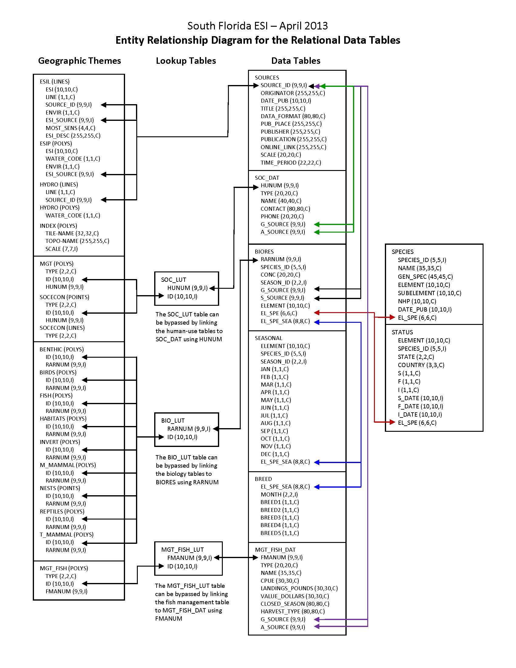
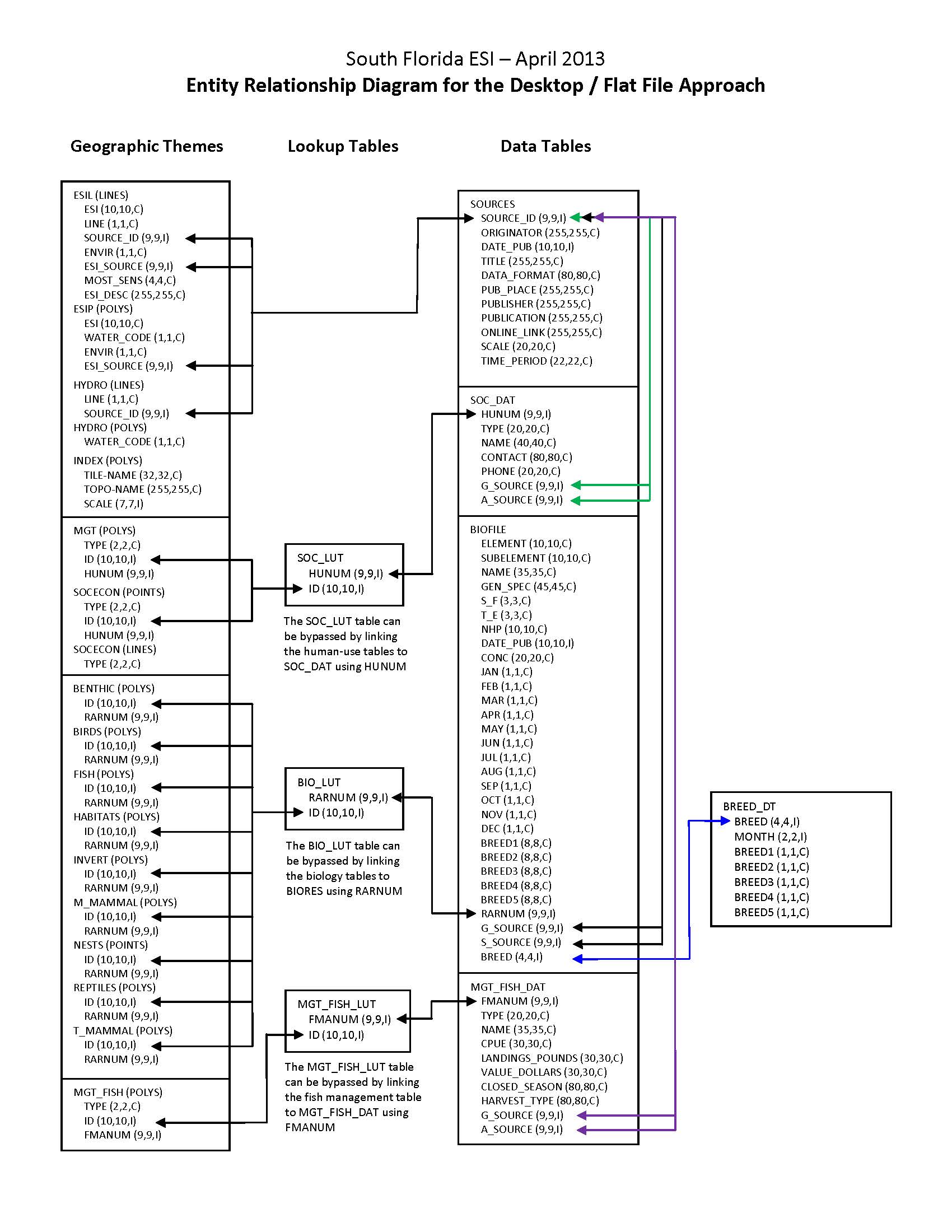
In addition to the geographic data layers, six relational attribute or data tables (BIORES, BREED, SEASONAL, SOURCES, SPECIES, and STATUS) are used to store the complex biological data in the ESI data structure. The geographic data layer containing biological resource information (in this case, BIRDS) is linked to the Biological Resources table (BIORES) using the unique ID and the lookup table BIO_LUT, or it can be linked directly using RARNUM. The ID is a unique combination of the atlas number (for the South Florida atlas, the number is 221), an element/layer specific number (BIRDS are layer 1, FISH are layer 2, etc.), and a unique record number. The RARNUM represents a unique combination of species, seasonalities, concentrations, and source information. For each of these groupings, a number is generated. That number is concatenated with the atlas number to create a "resource at risk" number that is unique across atlases. BIORES and the other relational data tables are described in the Detailed_Description sections. See the Browse_Graphic section for a link to the entity-relationship diagram, which describes the way these tables relate to the geographic data layers and other attribute tables in the ESI data structure. Due to the complexity of the relational database model, the data items are also post-processed into a flat file format. This table, called BIOFILE, may be used in place of the relational files to ease simple data queries. The items in the flat file are ELEMENT, SUBELEMENT, NAME, GEN_SPEC, S, F, NHP, DATE_PUB, CONC, JAN, FEB, MAR, APR, MAY, JUN, JUL, AUG, SEP, OCT, NOV, DEC, BREED1, BREED2, BREED3, BREED4, BREED5, RARNUM, G_SOURCE, S_SOURCE, and BREED. All of these items are the same as their counterparts in the individual data tables (described in the Detailed_Description sections), except the BREED1-BREED5 and BREED items. BREED is a newly generated variable used to link to the BREED_DT data table, a modified, more compact version of the relational BREED data table. BREED1-BREED5 give a text summary of when each life stage occurs within the associated map object. The life stages referred to are the same as those listed in the Detailed_Description of the BREED data table. The link to the BIOFILE may be made through the BIO_LUT, using ID to link to RARNUM, or BIOFILE may be linked directly to the RARNUM in each of the geographic layer's attribute data tables. As mentioned, BREED_DT is an auxiliary support data table to the flat file structure, which allows the user to do searches based on month for seasonal breeding activities. The link from the flat file to BREED_DT is the BREED item. A second supporting data table is SOURCES. This is the same as the source file described above, and the link from the flat file is both G_SOURCE and S_SOURCE. It should be noted that although the flat file eases data query, it is not a normalized database structure, and actual updates performed by the states and other responsible agencies should be done using the relational data tables. The entity-relationship diagram describing relationships between attribute tables in the ESI data structure does NOT include the BIOFILE data table, and this data table is NOT described in a Detailed_Description section. |
| Entity Attribute Detail Citation: |
A complete description of entity types, attributes, and attribute values for ESI atlases can be found in the NOAA ESI Guidelines (http://response.restoration.noaa.gov/esi_guidelines). |
| Distribution Liability: |
Although these data have been processed successfully on a computer system at the National Oceanic and Atmospheric Administration (NOAA), no warranty, expressed or implied, is made by NOAA regarding the utility of the data on any other system, nor shall the act of distribution constitute any such warranty. NOAA warrants the delivery of this product in computer-readable format. If problems are encountered in downloading the ESI data or with file corruption, contact NOAA (see Distributor). These data represent a snapshot in time and temporal changes may have occurred. The data are not intended to include all biological or human-use resources present in an area; they focus on species and resources particularly sensitive to oiling. In the event of a spill, they should be used for a first assessment only. The data providers are the experts with regard to individual resources. They should be contacted to confirm if more current data exist or if in-depth information is needed about a particular resource. |
| Data Set Credit: | This project was supported by the National Oceanic and Atmospheric Administration (NOAA), National Ocean Service (NOS), Office of Response and Restoration (OR&R), Emergency Response Division (ERD), Seattle, Washington; the Department of Homeland Security (DHS), United States Coast Guard (USCG), Office of Incident Management and Preparedness, Washington, D.C.; and the Fish and Wildlife Research Institute (FWRI), Florida Fish and Wildlife Conservation Commission (FWC), St. Petersburg, Florida. |
Support Roles
Data Steward
| Date Effective From: | 2013-04 |
|---|---|
| Date Effective To: | |
| Contact (Position): | ESI Program Manager |
| Address: |
7600 Sand Point Way NE Seattle, WA 98115 |
| Email Address: | orr.esi@noaa.gov |
Distributor
| Date Effective From: | 2013-04 |
|---|---|
| Date Effective To: | |
| Contact (Position): | ESI Program Manager |
| Address: |
7600 Sand Point Way NE Seattle, WA 98115 |
| Email Address: | orr.esi@noaa.gov |
Metadata Contact
| Date Effective From: | 2013-04 |
|---|---|
| Date Effective To: | |
| Contact (Position): | ESI Program Manager |
| Address: |
7600 Sand Point Way NE Seattle, WA 98115 |
| Email Address: | orr.esi@noaa.gov |
Point of Contact
| Date Effective From: | 2013-04 |
|---|---|
| Date Effective To: | |
| Contact (Position): | ESI Program Manager |
| Address: |
7600 Sand Point Way NE Seattle, WA 98115 |
| Email Address: | orr.esi@noaa.gov |
Extents
| Currentness Reference: | The data were compiled during 2011-2013. The currentness dates for the data range from 1971 to 2013 and are documented in the Lineage section. |
|---|
Extent Group 1
Extent Group 1 / Geographic Area 1
| W° Bound: | -82.933 | |
|---|---|---|
| E° Bound: | -80 | |
| N° Bound: | 26.375 | |
| S° Bound: | 24.5 |
Extent Group 1 / Time Frame 1
| Time Frame Type: | Range |
|---|---|
| Start: | 1971 |
| End: | 2013 |
Spatial Information
Spatial Representation
Representations Used
| Vector: | Yes |
|---|
Vector Representation 1
| Complex Object Present?: | Yes |
|---|---|
| Complex Object Count: | 1641 |
| Curve Object Present?: | Yes |
| Curve Object Count: | 531125 |
| Point Object Present?: | Yes |
| Point Object Count: | 1642 |
| Surface Object Present?: | Yes |
| Surface Object Count: | 2452 |
Access Information
| Security Class: | Unclassified |
|---|---|
| Data Access Procedure: |
Contact NOAA if you require the ESI data be provided to you on CD/DVD (see Distributor). ESI data are processed into multiple formats to make them useful to a wider community of GIS/mapping users. Distribution formats include ARC export files, Shapefiles, and a file Geodatabase (the recommended format). The database files are distributed both in the NOAA standard relational database format (see NOAA Technical Memorandum NOS ORCA 115) and in a simplified desktop flat file format. This metadata document includes information on both of these database formats.; |
| Data Access Constraints: |
None |
| Data Use Constraints: |
DO NOT USE MAPS FOR NAVIGATIONAL PURPOSES. Besides the above warning, there are no use constraints on these data. Note that the ESI database should not be used to the exclusion of other pertinent data or information held by state or federal agencies or other organizations. Likewise, information contained in the database cannot be used in place of consultations with environmental, natural resource, and cultural resource agencies, or in place of field surveys. Recognize that the information contained in the ESI database represents known concentration areas or occurrences of natural, cultural, and human-use resources, but does not necessarily represent the full distribution or range of each species or resource. This is particularly important to recognize when considering potential impacts to protected resources, such as endangered species, wetlands, etc. Acknowledgment of the originators, publishers, contributors, and sources listed would be appreciated in products derived from these data. |
Distribution Information
Distribution 1
| Download URL: | https://response.restoration.noaa.gov/esi_download |
|---|---|
| Distributor: | |
| Description: |
Downloadable Data |
| File Type (Deprecated): | Multiple formats |
URLs
URL 1
| URL: | https://response.restoration.noaa.gov/esi |
|---|---|
| URL Type: |
Online Resource
|
URL 2
| URL: | https://response.restoration.noaa.gov/esi_download |
|---|---|
| URL Type: |
Online Resource
|
URL 3
| URL: | https://response.restoration.noaa.gov/esi_guidelines |
|---|---|
| URL Type: |
Online Resource
|
URL 4
| URL: | https://response.restoration.noaa.gov/sites/default/files/esimaps/gisdata/SouthFlorida_2013_datafig.jpg |
|---|---|
| URL Type: |
Browse Graphic
|
| File Resource Format: | JPEG |
| Description: |
Depicts the relationships between spatial data layers and attribute data tables for the South Florida ESI data. |
URL 5
| URL: | https://response.restoration.noaa.gov/sites/default/files/esimaps/gisdata/SouthFlorida_2013_datafig2.jpg |
|---|---|
| URL Type: |
Browse Graphic
|
| File Resource Format: | JPEG |
| Description: |
Depicts the relationships between spatial data layers and desktop data tables for the South Florida ESI data. |
Activity Log
Activity Log 1
| Activity Date/Time: | 2014-06-16 |
|---|---|
| Description: |
Date that the source FGDC record was last modified. |
Activity Log 2
| Activity Date/Time: | 2017-04-05 |
|---|---|
| Description: |
Converted from Content Standards for Digital Geospatial Metadata (version FGDC-STD-001-1998) using 'fgdc_to_inport_xml.pl' script. Contact Tyler Christensen (NOS) for details. |
Activity Log 3
| Activity Date/Time: | 2017-09-13 |
|---|---|
| Description: |
Partial upload of Spatial Info section only. |
Activity Log 4
| Activity Date/Time: | 2017-11-01 |
|---|---|
| Description: |
Replaced entire Lineage section to populate new Source Contribution field. |
Activity Log 5
| Activity Date/Time: | 2018-02-08 |
|---|---|
| Description: |
Partial upload of Positional Accuracy fields only. |
Technical Environment
| Description: |
The software packages used to develop the atlas are Environmental Systems Research Institute's ARC/INFO(R) (version 10.0) and SQL SERVER(R) (version 2005). The hardware configuration is PCs with Windows Operating System 7. The Spatial_Data_Organization Information section refers only to the source files in the ARC export format. The following files are included in the data set: benthic.e00, birds.e00, esil.e00, esip.e00, fish.e00, habitats.e00, hydro.e00, index.e00, invert.e00, m_mammal.e00, mgt.e00, mgt_fish.e00, nests.e00, reptiles.e00, socecon.e00, and t_mammal.e00. Associated relational and desktop data tables provided in Arc export and text format are bio_lut.e00, biofile.e00, biores.e00, breed.e00, breed_dt.e00, mgt_fish_dat.e00, mgt_fish_lut.e00, seasonal.e00, soc_dat.e00, soc_lut.e00, sources.e00, species.e00, and status.e00. |
|---|
Data Quality
| Accuracy: |
A multi-stage error checking process is used to verify both attribute accuracy and logical consistency throughout data production. The process includes a standardized data entry methodology, hardcopy data review by in-house and external resource experts, a final Quality Assurance/Quality Control (QA/QC) process, and multiple automated logical consistency checks. Quantitative data (such as densities, counts, abundances, or concentrations) provided by resource experts for inclusion in the data set may vary widely in attribute accuracy, depending upon the methodology used to collect and compile such data. For a more detailed evaluation of source data attribute accuracy, contact the sources listed in the Lineage section. |
|---|---|
| Horizontal Positional Accuracy: |
Spatial components for the biological data layers can come from expert interviews, hardcopy, or digital sources. Some of the spatial components of the biological data layers may have been developed using regional experts who estimate concentration areas. It is difficult to estimate the positional accuracy of such data, except to state that they are compiled on hardcopy base maps with a scale of 1:24,000. Some of the spatial components of the biological data sets are developed from pre-existing digital or hardcopy sources and reflect the positional accuracy of these original data. Note that biological resource data by their very nature are considered "fuzzy", and this should be understood when considering the positional accuracy of vector digital objects representing these resources. See the Lineage and Process_Description sections for more information on the original source data and how these data were integrated or manipulated to create the final data set. |
| Completeness Report: |
These data represent a synthesis of expert knowledge, survey data, digital maps, published reports, peer-reviewed articles, and digital data on bird nesting, migratory staging, wintering, and foraging/resting sites. See also the NESTS (Nest Points) data layer, part of the larger South Florida ESI database, for additional bird information. These data do not necessarily represent all bird occurrences in South Florida. The following species are included in this data set: (Species_ID, Common Name, Scientific Name [n/a if not applicable]): 1, Common loon, Gavia immer; 5, Horned grebe, Podiceps auritus; 8, Double-crested cormorant, Phalacrocorax auritus; 33, Red-breasted merganser, Mergus serrator; 34, American coot, Fulica americana; 38, Herring gull, Larus argentatus; 40, Ring-billed gull, Larus delawarensis; 54, Great blue heron, Ardea herodias; 55, Whimbrel, Numenius phaeopus; 56, Spotted sandpiper, Actitis macularia; 58, Greater yellowlegs, Tringa melanoleuca; 60, Red knot, Calidris canutus; 62, Least sandpiper, Calidris minutilla; 63, Dunlin, Calidris alpina; 64, Short-billed dowitcher, Limnodromus griseus; 65, Long-billed dowitcher, Limnodromus scolopaceus; 66, Western sandpiper, Calidris mauri; 67, Sanderling, Calidris alba; 69, Semipalmated plover, Charadrius semipalmatus; 70, Killdeer, Charadrius vociferus; 71, Black-bellied plover, Pluvialis squatarola; 73, Ruddy turnstone, Arenaria interpres; 76, Bald eagle, Haliaeetus leucocephalus; 77, Osprey, Pandion haliaetus; 86, Least tern, Sternula antillarum; 87, Little blue heron, Egretta caerulea; 88, Great egret, Ardea alba; 89, Snowy egret, Egretta thula; 90, Black-crowned night-heron, Nycticorax nycticorax; 93, Cattle egret, Bubulcus ibis; 94, Tricolored heron, Egretta tricolor; 95, Roseate tern, Sterna dougallii; 97, Green heron, Butorides virescens; 98, Laughing gull, Larus atricilla; 107, Peregrine falcon, Falco peregrinus; 115, White ibis, Eudocimus albus; 116, Roseate spoonbill, Ajaia ajaja; 117, Great white heron, Ardea herodias; 118, Brown pelican, Pelecanus occidentalis; 119, Magnificent frigatebird, Fregata magnificens; 120, Yellow-crowned night-heron, Nyctanassa violacea; 121, Anhinga, Anhinga anhinga; 126, Brown noddy, Anous stolidus; 127, Sooty tern, Onychoprion fuscatus; 128, Masked booby, Sula dactylatra; 132, Wood stork, Mycteria americana; 133, Black skimmer, Rynchops niger; 135, Sandwich tern, Thalasseus sandvicensis; 136, Caspian tern, Hydroprogne caspia; 137, Royal tern, Thalasseus maximus; 138, Forster's tern, Sterna forsteri; 139, Snowy plover, Charadrius alexandrinus; 142, Black-necked stilt, Himantopus mexicanus; 153, Piping plover, Charadrius melodus; 154, Wilson's plover, Charadrius wilsonia; 155, Willet, Catoptrophorus semipalmatus; 156, Semipalmated sandpiper, Calidris pusilla; 163, Reddish egret, Egretta rufescens; 167, Northern gannet, Morus bassanus; 173, American white pelican, Pelecanus erythrorhynchos; 179, Pied-billed grebe, Podilymbus podiceps; 181, Northern harrier, Circus cyaneus; 182, American kestrel, Falco sparverius; 190, Blue-winged teal, Anas discors; 209, Long-billed curlew, Numenius americanus; 210, Marbled godwit, Limosa fedoa; 213, Stilt sandpiper, Calidris himantopus; 216, Belted kingfisher, Ceryle alcyon; 218, Red-shouldered hawk, Buteo lineatus; 219, Sharp-shinned hawk, Accipiter striatus; 220, Merlin, Falco columbarius; 221, Cooper's hawk, Accipiter cooperii; 231, Broad-winged hawk, Buteo platypterus; 249, Black noddy, Anous minutus; 261, Brown booby, Sula leucogaster; 277, Seaside sparrow, Ammodramus maritimus; 280, Swallow-tailed kite, Elanoides forficatus; 283, Bridled tern, Onychoprion anaethetus; 294, Cape Sable seaside sparrow, Ammodramus maritimus mirabilis; 297, White-crowned pigeon, Patagioenas leucocephala; 334, Yellow warbler, Dendroica petechia; 354, Short-tailed hawk, Buteo brachyurus; 357, Swainson's hawk, Buteo swainsoni; 367, American flamingo, Phoenicopterus ruber; 393, Lesser black-backed gull, Larus fuscus; 420, Mangrove cuckoo, Coccyzus minor; 455, Yellow-billed cuckoo, Coccyzus americanus; 458, Northern waterthrush, Seiurus noveboracensis; 459, Florida burrowing owl, Athene cunicularia floridana; 590, Black-and-white warbler, Mniotilta varia; 722, Common yellowthroat, Geothlypis trichas; 843, White-eyed vireo, Vireo griseus; 861, Yellow-throated warbler, Setophaga dominica; 862, Prairie warbler, Setophaga discolor; 863, Palm warbler, Setophaga palmarum; 1001, Gulls, n/a; 1002, Shorebirds, n/a; 1004, Wading birds, n/a; 1005, Raptors, n/a; 1006, Diving birds, n/a; 1008, Terns, n/a; 1038, Warblers, Parulidae; 1039, Thrushes, n/a. |
| Conceptual Consistency: |
A multi-stage error checking process, described in the above Attribute_Accuracy_Report, is used to verify both attribute accuracy and logical consistency throughout data production. This process includes multiple automated logical consistency checks that test the files for missing or duplicate data, rules for proper coding, GIS topological consistencies (such as dangles, unnecessary node, etc.), and SQL SERVER(R) to ARC/INFO(R) consistencies. After the data are delivered to NOAA, they are again subjected to a number of quality and consistency checks. In the process of checking for topological and database consistencies, new ID's and RARNUM's or HUNUM's are also generated. The new ID's are a combination of atlas number, element number, and record number. In addition, the value used to represent the element is modified to reflect the type of feature being mapped. In the case of an element that is normally represented by a point or polygon, a value of 20 is added to the standard element value for mapping of linear features. In the case where an element usually mapped as a polygon is represented by a point, a value of 30 is added to the regular element value. The RARNUM's are also modified to include the atlas number, so multiple atlases can be combined and RARNUM's remain unique. RARNUM's are redefined on an element basis, so "resources at risk" groupings will contain only a single element. HUNUM's are also modified to include the atlas number. |
Lineage
Sources
ABUNDANCE, POPULATION STATUS, AND BREEDING-SEASON HABITAT REQUIREMENTS OF MANGROVE LANDBIRDS IN SOUTHERN FLORIDA
| Contact Name: | LLOYD, J.D. AND K.E. MILLER |
|---|---|
| Publish Date: | 2011-01-01 |
| Extent Type: | Discrete |
| Extent Start Date/Time: | 2011 |
| Source Contribution: |
BIRDS INFORMATION | Source Geospatial Form: HARDCOPY TEXT | Type of Source Media: EMAIL |
BIRD DISTRIBUTION AND SEASONALITY IN FLORIDA BAY
| Contact Name: | FREZZA, P. (AUDUBON OF FLORIDA) |
|---|---|
| Publish Date: | 2013-01-01 |
| Extent Type: | Discrete |
| Extent Start Date/Time: | 2013 |
| Source Contribution: |
BIRDS INFORMATION | Source Geospatial Form: EXPERT KNOWLEDGE | Type of Source Media: PERSONAL COMMUNICATION |
BIRD DISTRIBUTION IN EVERGLADES NATIONAL PARK AND FLORIDA BAY
| Contact Name: | OBERHOFER, L. (NATIONAL PARK SERVICE (NPS), EVERGLADES NATIONAL PARK) |
|---|---|
| Publish Date: | 2012-01-01 |
| Extent Type: | Discrete |
| Extent Start Date/Time: | 2012 |
| Source Contribution: |
BIRDS INFORMATION | Source Geospatial Form: EXPERT KNOWLEDGE | Type of Source Media: PERSONAL COMMUNICATION |
BIRDING TIPS, ETHICS, AND WHERE TO BIRD IN BISCAYNE
| Contact Name: | NATIONAL PARK SERVICE (NPS), BISCAYNE NATIONAL PARK |
|---|---|
| Publish Date: | 2012-01-01 |
| Extent Type: | Discrete |
| Extent Start Date/Time: | 2012 |
| Citation URL: | http://www.nps.gov/bisc/naturescience/birding.htm |
| Source Contribution: |
BIRDS INFORMATION | Source Geospatial Form: WEBSITE | Type of Source Media: online |
BISCAYNE BAY NATIONAL PARK RESOURCES
| Contact Name: | NATIONAL PARK SERVICE (NPS) MIAMI |
|---|---|
| Publish Date: | 2012-01-01 |
| Extent Type: | Discrete |
| Extent Start Date/Time: | 2012 |
| Source Contribution: |
BIRDS INFORMATION | Source Geospatial Form: EXPERT KNOWLEDGE | Type of Source Media: PERSONAL COMMUNICATION |
CAPE SABLE SEASIDE SPARROW OCCUPANCY AREA
| Contact Name: | ALVARADO, M. (EVERGLADES NATIONAL PARK, NATIONAL PARK SERVICE (NPS)) |
|---|---|
| Publish Date: | 2012-01-01 |
| Extent Type: | Discrete |
| Extent Start Date/Time: | 2012 |
| Source Contribution: |
BIRDS INFORMATION | Source Geospatial Form: vector digital data | Type of Source Media: EMAIL |
DISTRIBUTION AND SEASONALITY OF BIRDS AND REPTILES IN SOUTH FL
| Contact Name: | ZAMBRANO, R. (FLORIDA FISH AND WILDLIFE CONSERVATION COMMISSION (FWC)) |
|---|---|
| Publish Date: | 2012-01-01 |
| Extent Type: | Discrete |
| Extent Start Date/Time: | 2012 |
| Source Contribution: |
BIRDS INFORMATION | Source Geospatial Form: EXPERT KNOWLEDGE | Type of Source Media: PERSONAL COMMUNICATION |
DISTRIBUTION AND SEASONALITY OF BIRDS AND REPTILES IN SOUTH FLORIDA
| Contact Name: | WILMERS, T. (UNITED STATES FISH AND WILDLIFE SERVICE (USFWS), FLORIDA KEYS NATIONAL WILDLIFE REFUGES) |
|---|---|
| Publish Date: | 2012-01-01 |
| Extent Type: | Discrete |
| Extent Start Date/Time: | 2012 |
| Source Contribution: |
BIRDS INFORMATION | Source Geospatial Form: EXPERT KNOWLEDGE | Type of Source Media: PERSONAL COMMUNICATION |
DISTRIBUTION AND SEASONALITY OF FLORIDA BAY BIRDS
| Contact Name: | LORENZ, J. (AUDUBON OF FLORIDA) |
|---|---|
| Publish Date: | 2013-01-01 |
| Extent Type: | Discrete |
| Extent Start Date/Time: | 2013 |
| Source Contribution: |
BIRDS INFORMATION | Source Geospatial Form: EXPERT KNOWLEDGE | Type of Source Media: PERSONAL COMMUNICATION |
DRY TORTUGAS NATIONAL PARK BIRD CHECKLIST
| Contact Name: | NATIONAL PARK SERVICE (NPS) |
|---|---|
| Publish Date: | 2004-01-01 |
| Extent Type: | Discrete |
| Extent Start Date/Time: | 2004 |
| Citation URL: | http://www.nps.gov/drto/planyourvisit/loader.cfm?csModule=security/getfile&PageID=178974 |
| Source Contribution: |
BIRDS INFORMATION | Source Geospatial Form: document | Type of Source Media: ONLINE |
DRY TORTUGAS NATIONAL PARK BIRD COLONIES
| Contact Name: | NATIONAL PARK SERVICE (NPS) SOUTH FLORIDA/CARIBBEAN NETWORK |
|---|---|
| Publish Date: | 2012-01-01 |
| Extent Type: | Discrete |
| Extent Start Date/Time: | 2012 |
| Source Contribution: |
BIRDS INFORMATION | Source Geospatial Form: vector digital data | Type of Source Media: EMAIL |
EBIRD DATA FOR THE DRY TORTUGAS, EVERGLADES, AND BISCAYNE BAY NATIONAL PARKS
| Contact Name: | PATTERSON, J. (NATIONAL PARK SERVICE/CARIBBEAN NETWORK) |
|---|---|
| Publish Date: | 2013-01-01 |
| Extent Type: | Discrete |
| Extent Start Date/Time: | 2013 |
| Source Contribution: |
BIRDS INFORMATION | Source Geospatial Form: spreadsheet | Type of Source Media: EMAIL |
EVERGLADES WOOD STORK FORAGING DATA
| Contact Name: | ALVARADO, M. (EVERGLADES NATIONAL PARK, NATIONAL PARK SERVICE (NPS)) |
|---|---|
| Publish Date: | 2013-01-01 |
| Extent Type: | Range |
| Extent Start Date/Time: | 1985 |
| Extent End Date/Time: | 2012 |
| Source Contribution: |
BIRDS INFORMATION | Source Geospatial Form: spreadsheet | Type of Source Media: EMAIL |
FLORIDA KEYS NATIONAL WILDLIFE REFUGES BIRD LIST
| Contact Name: | UNITED STATES FISH AND WILDLIFE SERVICE (USFWS) |
|---|---|
| Publish Date: | 2002-01-01 |
| Extent Type: | Discrete |
| Extent Start Date/Time: | 2002 |
| Source Contribution: |
BIRDS INFORMATION | Source Geospatial Form: document | Type of Source Media: online |
FLORIDA NATURAL AREAS INVENTORY, FLORIDA ELEMENT OCCURRENCE
| Contact Name: | FLORIDA NATURAL AREAS INVENTORY (FNAI) |
|---|---|
| Publish Date: | 2011-01-01 |
| Extent Type: | Discrete |
| Extent Start Date/Time: | 2011 |
| Source Contribution: |
BIRDS INFORMATION | Source Geospatial Form: vector digital data | Type of Source Media: EMAIL |
FLORIDA'S BIRDS: A FIELD GUIDE AND REFERENCE
| Contact Name: | MAEHR, D. S. AND KALE, H. W. II |
|---|---|
| Publish Date: | 2009-01-01 |
| Extent Type: | Discrete |
| Extent Start Date/Time: | 2009 |
| Source Contribution: |
BIRDS INFORMATION | Source Geospatial Form: HARDCOPY TEXT | Type of Source Media: BOOK |
GOOGLE EARTH FILE:BROWN PELICANS AND MAGNICENT FRIGATEBIRDS IN THE FLORIDA KEYS AND FLORIDA BAY
| Contact Name: | OBERHOFER, L. (NATIONAL PARK SERVICE (NPS), EVERGLADES NATIONAL PARK) |
|---|---|
| Publish Date: | 2013-01-01 |
| Extent Type: | Discrete |
| Extent Start Date/Time: | 2013 |
| Source Contribution: |
BIRDS INFORMATION | Source Geospatial Form: map | Type of Source Media: EMAIL |
KEY LARGO-PLANTATION KEY CHRISTMAS BIRD COUNT 2008-2012
| Contact Name: | FREZZA, P. (AUDUBON OF FLORIDA) |
|---|---|
| Publish Date: | 2012-01-01 |
| Extent Type: | Range |
| Extent Start Date/Time: | 2008 |
| Extent End Date/Time: | 2012 |
| Source Contribution: |
BIRDS INFORMATION | Source Geospatial Form: spreadsheet | Type of Source Media: EMAIL |
LOWER FLORIDA KEYS NATIONAL WILDLIFE REFUGES COMPREHENSIVE CONSERVATION PLAN
| Contact Name: | LOWER FLORIDA KEYS NATIONAL WILDLIFE REFUGES |
|---|---|
| Publish Date: | 2009-01-01 |
| Extent Type: | Discrete |
| Extent Start Date/Time: | 2009 |
| Source Contribution: |
BIRDS INFORMATION | Source Geospatial Form: document | Type of Source Media: ONLINE |
MID-WINTER WATERFOWL INVENTORY DATA
| Contact Name: | MIDWINTER WATERFOWL INVENTORY |
|---|---|
| Publish Date: | 2003-01-01 |
| Extent Type: | Range |
| Extent Start Date/Time: | 1971 |
| Extent End Date/Time: | 2003 |
| Source Contribution: |
BIRDS INFORMATION | Source Geospatial Form: spreadsheet | Type of Source Media: EMAIL |
NATIONAL PARK SERVICE RESOURCES
| Contact Name: | PATTERSON, J. (NATIONAL PARK SERVICE/CARIBBEAN NETWORK) |
|---|---|
| Publish Date: | 2013-01-01 |
| Extent Type: | Discrete |
| Extent Start Date/Time: | 2013 |
| Source Contribution: |
BIRDS INFORMATION | Source Geospatial Form: EXPERT KNOWLEDGE | Type of Source Media: paper |
NESTING STATUS AND COLONY SITE VARIABILITY OF LAUGHING GULLS IN SOUTHERN FLORIDA
| Contact Name: | FROHRING, P. C. AND J. A. KUSHLAN |
|---|---|
| Publish Date: | 1986-01-01 |
| Extent Type: | Discrete |
| Extent Start Date/Time: | 1986 |
| Source Contribution: |
BIRDS INFORMATION | Source Geospatial Form: document | Type of Source Media: EMAIL |
PIPING PLOVER CRITICAL HABITAT
| Contact Name: | UNITED STATES FISH AND WILDLIFE SERVICE (USFWS) |
|---|---|
| Publish Date: | 2001-01-01 |
| Extent Type: | Discrete |
| Extent Start Date/Time: | 2001 |
| Citation URL: | http://criticalhabitat.fws.gov/ |
| Source Contribution: |
BIRDS INFORMATION | Source Geospatial Form: vector digital data | Type of Source Media: online |
SENSITIVITY OF COASTAL ENVIRONMENTS AND WILDLIFE TO SPILLED OIL: SOUTH FLORIDA ATLAS
| Contact Name: | NATIONAL OCEANIC ATMOSPHERIC ADMINISTRATION (NOAA), NATIONAL OCEAN SERVICE (NOS), OFFICE OF RESPONSE AND RESTORATION (OR&R), EMERGENCY RESPONSE DIVISION (ERD) |
|---|---|
| Publish Date: | 1996-01-01 |
| Extent Type: | Discrete |
| Extent Start Date/Time: | 1996 |
| Citation URL: | https://response.restoration.noaa.gov/esi |
| Source Contribution: |
BIRDS INFORMATION | Source Geospatial Form: atlas | Type of Source Media: ATLAS HARDCOPY |
SOUTH FLORIDA INTERNATIONAL WINTER PLOVER CENSUS 2011
| Contact Name: | 2011 INTERNATIONAL WINTER PLOVER CENSUS, UNITED STATES FISH AND WILDLIFE SERVICE (USFWS), SOUTH FLORIDA ECOLOGICAL SERVICES OFFICE |
|---|---|
| Publish Date: | 2011-01-01 |
| Extent Type: | Discrete |
| Extent Start Date/Time: | 2011 |
| Source Contribution: |
BIRDS INFORMATION | Source Geospatial Form: vector digital data | Type of Source Media: EMAIL |
THE IMPORTANT BIRD AREAS OF FLORIDA
| Contact Name: | PRANTY, B. (FLORIDA MUSEUM OF NATURAL HISTORY), AUDUBON OF FLORIDA; NOSS, R. F. AND S. SINGH, EDS. |
|---|---|
| Publish Date: | 2010-01-01 |
| Extent Type: | Discrete |
| Extent Start Date/Time: | 2010 |
| Source Contribution: |
BIRDS INFORMATION | Source Geospatial Form: document | Type of Source Media: EMAIL |
Process Steps
Process Step 1
| Description: |
Three main sources of data were used to depict bird distribution and seasonality for this data layer: 1) personal interviews with resource experts from Florida Fish and Wildlife Conservation Commission (FWC), Audubon of Florida, National Park Service (NPS) - Everglades National Park, Biscayne Bay National Park, Dry Tortugas National Park, and U.S. Fish and Wildlife Service (USFWS) - Florida Keys National Wildlife Refuges; 2) digital data sets (based on field surveys) provided by: NPS - Everglades National Park and Dry Tortugas National Park and USFWS; and 3) literature provided by Audubon of Florida and NPS. Survey data on locations of breeding, wintering, and resident birds was provided via shapefiles for the following species and species groups in the BIRDS layer (other nest points were included in the NESTS layer): Dry Tortugas National Park breeding colonies, wood stork, Cape Sable seaside sparrow, brown pelican, and magnificent frigatebird. For species and data sets for which concentration information was available, if the data provided contained a single year of count data, that count was displayed in the concentration field. For data sets with multiple years of data the maximum value or most recent year recorded at a site over the months or years surveyed is displayed in the concentration field. USFWS, NPS, Audubon of FL, and FFWCC staff provided additional insight on birds that nest on the Florida Keys and keys within Florida Bay. Bird data collected through Christmas Bird Counts and reported to www.eBird.org were used to depict species utilizing the Dry Tortugas, Florida Bay, and Biscayne Bay. The above digital and/or hardcopy sources were compiled by the project biologist to create the BIRDS data layer. Depending on the type of source data, three general approaches are used for compiling the data layer: 1) information gathered during initial interviews and from hardcopy sources are compiled onto U.S. Geological Survey 1:24,000 topographic quadrangles and digitized; 2) hardcopy maps are digitized at their source scale; 3) digital data layers are evaluated and used "as is" or integrated with the hardcopy data sources. See the Lineage section for additional information on the type of source data for this data layer. The compiled ESI, biology, and human-use data are plotted onto hardcopy draft maps. Following the delivery of draft maps to the participating resource experts, a second set of interviews are conducted to review the maps. If necessary, edits to the BIRDS data layer are made based on the recommendations of the resource experts, and final hardcopy maps and digital data are created. |
|---|---|
| Process Date/Time: | 2013-04-01 00:00:00 |
Child Items
Rubric scores updated every 15m
| Type | Title |
|---|---|
| Entity | BIORES |
| Entity | BIO_LUT |
| Entity | BIRDS.PAT |
| Entity | BREED |
| Entity | SEASONAL |
| Entity | SOURCES |
| Entity | SPECIES |
| Entity | STATUS |
Catalog Details
| Catalog Item ID: | 40696 |
|---|---|
| GUID: | gov.noaa.nmfs.inport:40696 |
| Metadata Record Created By: | Tyler Christensen |
| Metadata Record Created: | 2017-04-05 14:53+0000 |
| Metadata Record Last Modified By: | SysAdmin InPortAdmin |
| Metadata Record Last Modified: | 2025-05-15 19:16+0000 |
| Metadata Record Published: | 2018-02-08 |
| Owner Org: | ORR |
| Metadata Publication Status: | Published Externally |
| Do Not Publish?: | N |
| Metadata Last Review Date: | 2018-02-08 |
| Metadata Review Frequency: | 1 Year |
| Metadata Next Review Date: | 2019-02-08 |