Klawock Lagoon, Alaska Benthic Habitats 2011 Geoform
Data Set (DS) | Office for Coastal Management (OCM)GUID: gov.noaa.nmfs.inport:47848 | Updated: May 30, 2023 | Published / External
Summary
Short Citation
Office for Coastal Management, 2024: Klawock Lagoon, Alaska Benthic Habitats 2011 Geoform, https://www.fisheries.noaa.gov/inport/item/47848.
Full Citation Examples
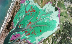
The Klawock River on Alaska's Prince of Wales Island drains a 29,061 acre watershed with 132 miles of streambed habitat supporting seven salmon and trout species. Traditionally the river and lagoon supported salmon harvests exceeding 30,000 fish annually. The salmon fishery is an important economic factor and food source in the Klawock area. It is also an important cultural resource to local inhabitants. In 1964 a causeway was constructed blocking access to the lagoon from adjacent Klawock Bay. This has resulted in dramatic decreases in salmon harvests. The Nature Conservancy has lead a broad partnership to construct a culvert through the causeway thus re-establishing free passage between the river and Klawock Bay which is expected to help restore a full use of the river as spawning habitat by salmon and generally improve the quality of the lagoon. Benthic habitats in the lagoon and adjacent Klawock Bay and Klawock Harbor were mapped in spring 2011 to establish a baseline of benthic communities in the area with emphasis on eelgrass beds which are essential to the early survival of salmon fry. The habitat map will guide ongoing monitoring activities in the lagoon and form the basis of future change detection efforts.
Aerial multi-spectral imagery was collected over the lagoon, bay, and harbor during the week of April 19, 2011. The mission was timed to coincide with the breaching of the causeway. The environmental considerations important to successful benthic mapping were incorporated into the mission planning. These included, imagery to be collected within 1.5 hours of a zero or negative tide, clear water conditions (no algal blooms, or sediment plumes from runoff), low winds to avoid surface waves, and sufficient solar illumination to image submerged areas. These collection parameters were defined by the Office for Coastal Management prior to collection of the imagery. Despite weather and water conditions which were not ideal, imagery adequate to map most of the habitats in the lagoon was successfully collected on April 19, 2011.
Eelgrass habitats in the Lagoon did not have sufficient biomass or illumination through the water column at the time of the aerial mission to be mapped from that source so eelgrass habitats were determined by two field-digitizing processes, one in August 2010 and one in September 2011. The final hybrid map captures habitats 10m x 10m or larger and has the same positional accuracy as the source imagery.
Field data to guide the mapping was supplied by several project partners. A comparison between the field data and the map shows high levels of agreement, although no traditional quantitative accuracy assessment was conducted.
Original contact information:
Contact Org: NOAA Office for Coastal Management
Phone: 843-740-1202
Email: coastal.info@noaa.gov
Distribution Information
-
FTP download of data files.
Data is available upon request
None
Controlled Theme Keywords
BENTHIC, COASTAL, environment, ESTUARY
Child Items
| Type | Title |
|---|---|
| Entity | Geoform |
URLs
URL 1
| URL: | https://iocm.noaa.gov/cmecs |
|---|---|
| Name: | CMECS Home Page |
| URL Type: |
Online Resource
|
| Description: |
Information and resources on the CMECS standard and how to apply it |
URL 2
| URL: | http://www.cmecscatalog.org/ |
|---|---|
| Name: | CMECS Catalog |
| URL Type: |
Online Resource
|
| Description: |
Searchable online catalog of CMECS units, descriptions, and source references |
URL 3
| URL: | https://coast.noaa.gov/digitalcoast/ |
|---|---|
| Name: | NOAA's Office for Coastal Management (OCM) Digital Coast Data section |
| URL Type: |
Online Resource
|
| Description: |
The website provides not only coastal data, but also the tools, training, and information needed to make these data truly useful. Content comes from many sources, all of which are vetted by NOAA. |
URL 4
| URL: | https://coast.noaa.gov/ |
|---|---|
| Name: | NOAA's Office for Coastal Management (OCM) website |
| URL Type: |
Online Resource
|
| Description: |
Information on the NOAA Office for Coastal Management (OCM) |
URL 5
| URL: | https://coast.noaa.gov/data/Images/Collections/BenthicCover_thumbnail.jpg |
|---|---|
| Name: | Browse Graphic |
| URL Type: |
Browse Graphic
|
| File Resource Format: | JPEG |
| Description: |
Sample of benthic cover data |
Child Items
Rubric scores updated every 15m
| Type | Title |
|---|---|
| Entity | Geoform |