Humboldt Bay, California Benthic Habitats 2009 Geodatabase
Data Set (DS) | Office for Coastal Management (OCM)GUID: gov.noaa.nmfs.inport:47853 | Updated: May 30, 2023 | Published / External
Summary
Short Citation
Office for Coastal Management, 2025: Humboldt Bay, California Benthic Habitats 2009 Geodatabase, https://www.fisheries.noaa.gov/inport/item/47853.
Full Citation Examples
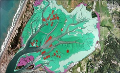
Humboldt Bay is the largest estuary in California north of San Francisco Bay and represents a significant resource for the
north coast region. Beginning in 2007 the Office for Coastal Management began collaborating with the California SeaGrant program and
other local partners to support an ecosystem-based management (EBM) project for Humboldt Bay. One element of this project was to
develop subtidal habitat goals for the long-term management of the bay and provide a framework for conservation and management across
the land-sea interface. The imagery collection and benthic habitat delineation for Humboldt Bay were essential to the development of
subtidal goals and implementation of EBM for the region. Together, these efforts will provide important and replicable data and an
information framework for ecosystem-based coastal and marine conservation planning and implementation. 12 Bit 4 Band imagery was
collected in June,2009 within 1 hour of either side of a minus one (-1) foot tide with low turbidity,low wind,low sun angle and no cloud cover. The horizontal spatial accuracy of the imagery is within +/- 3 meters CE95 of position on the ground and was captured at a spatial resolution (pixel size) of 0.54m x 0.54m. The imagery was tiled and named according to the existing USGS digital ortho quarter quad boundaries (ex. Arcata_South_NE.tif). A small buffer (~100 m) was produced with each tile to prevent gaps in coverage. Habitat features were interpreted and digitized on screen in an ARCGIS Geodatabase 9.3 resulting in accurate and efficient 3D extraction of the data. Habitats were delineated with a high level of detail with the minimum mapping unit (MMU) being 0.01 hectares(approx.10m x 10m).
Original contact information:
Contact Org: NOAA Office for Coastal Management
Phone: 843-740-1202
Email: coastal.info@noaa.gov
PurposeThe data was developed to support ecosystem based management in the Humboldt Bay region. The focus of the mapping was on shallow water benthic habitats with particular concern for eelgrass meadows.
Distribution Information
-
FTP download of data files.
Data is available upon request
None
Controlled Theme Keywords
BENTHIC, COASTAL, environment, ESTUARY
URLs
-
Information and resources on the CMECS standard and how to apply it
-
Searchable online catalog of CMECS units, descriptions, and source references
-
The website provides not only coastal data, but also the tools, training, and information needed to make these data truly useful. Content comes from many sources, all of which are vetted by NOAA.
-
Information on the NOAA Office for Coastal Management (OCM)
Child Items
No Child Items for this record.
URLs
URL 1
| URL: | https://iocm.noaa.gov/cmecs |
|---|---|
| Name: | CMECS Home Page |
| URL Type: |
Online Resource
|
| Description: |
Information and resources on the CMECS standard and how to apply it |
URL 2
| URL: | http://www.cmecscatalog.org/ |
|---|---|
| Name: | CMECS Catalog |
| URL Type: |
Online Resource
|
| Description: |
Searchable online catalog of CMECS units, descriptions, and source references |
URL 3
| URL: | https://coast.noaa.gov/digitalcoast/ |
|---|---|
| Name: | NOAA's Office for Coastal Management (OCM) Digital Coast Data section |
| URL Type: |
Online Resource
|
| Description: |
The website provides not only coastal data, but also the tools, training, and information needed to make these data truly useful. Content comes from many sources, all of which are vetted by NOAA. |
URL 4
| URL: | https://coast.noaa.gov/ |
|---|---|
| Name: | NOAA's Office for Coastal Management (OCM) website |
| URL Type: |
Online Resource
|
| Description: |
Information on the NOAA Office for Coastal Management (OCM) |
URL 5
| URL: | https://coast.noaa.gov/data/Images/Collections/BenthicCover_thumbnail.jpg |
|---|---|
| Name: | Browse Graphic |
| URL Type: |
Browse Graphic
|
| File Resource Format: | JPEG |
| Description: |
Sample of benthic cover data |