Shallow benthic habitats of San Francisco Bay, California CMECS substrate component
Data Set (DS) | Office for Coastal Management (OCM)GUID: gov.noaa.nmfs.inport:47859 | Updated: May 30, 2023 | Published / External
Summary
Short Citation
Office for Coastal Management, 2025: Shallow benthic habitats of San Francisco Bay, California CMECS substrate component, https://www.fisheries.noaa.gov/inport/item/47859.
Full Citation Examples
This dataset has been developed for the National Oceanic and Atmospheric Administration's (NOAA) Office for Coastal Management (OCM) as a collaborative and cooperative project with the California State Coastal Conservancy (SCC) on behalf of the Ocean Protection Council (OPC) to collect and delineate habitat data in the San Francisco Bay area. Data is intended for use in coastal management decision making, including applications such as sea level rise. The mission of the Center is to support the environmental, social, and economic well-being of the coast by linking people, information, and technology.
Original contact information:
Contact Org: NOAA Office for Coastal Management
Phone: (843)740-1202
Email: coastal.info@noaa.gov
PurposeSan Francisco Bay is the largest estuary in California and represents a significant resource for the Central California region. This dataset is intended to support the local coastal zone managers in their decision-making processes. This project will assist with the subtidal habitat goals for the long-term management of the bay.
Distribution Information
-
FTP download of data files.
None
Acknowledgment of Dewberry would be appreciated in products derived from this data.
Controlled Theme Keywords
BENTHIC, COASTAL, environment, ESTUARY
URLs
-
Information and resources on the CMECS standard and how to apply it
-
Searchable online catalog of CMECS units, descriptions, and source references
-
The website provides not only coastal data, but also the tools, training, and information needed to make these data truly useful. Content comes from many sources, all of which are vetted by NOAA.
Child Items
| Type | Title |
|---|---|
| Entity | ca_sfb11-Substrate |
URLs
URL 1
| URL: | https://iocm.noaa.gov/cmecs |
|---|---|
| Name: | CMECS Home Page |
| URL Type: |
Online Resource
|
| Description: |
Information and resources on the CMECS standard and how to apply it |
URL 2
| URL: | http://www.cmecscatalog.org/ |
|---|---|
| Name: | CMECS Catalog |
| URL Type: |
Online Resource
|
| Description: |
Searchable online catalog of CMECS units, descriptions, and source references |
URL 3
| URL: | https://coast.noaa.gov/digitalcoast/ |
|---|---|
| Name: | NOAA's Office for Coastal Management (OCM) Digital Coast Data section |
| URL Type: |
Online Resource
|
| Description: |
The website provides not only coastal data, but also the tools, training, and information needed to make these data truly useful. Content comes from many sources, all of which are vetted by NOAA. |
URL 4
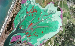
| URL: | https://coast.noaa.gov/data/Images/Collections/BenthicCover_thumbnail.jpg |
|---|---|
| Name: | Browse Graphic |
| URL Type: |
Browse Graphic
|
| File Resource Format: | JPEG |
| Description: |
Sample of benthic cover data |
Child Items
Rubric scores updated every 15m
| Type | Title |
|---|---|
| Entity | ca_sfb11-Substrate |