Benthic Habitats and Surficial Geology of Apalachicola Bay, Florida 2006 Biotic
Data Set (DS) | Office for Coastal Management (OCM)GUID: gov.noaa.nmfs.inport:47872 | Updated: April 30, 2025 | Published / External
Summary
Short Citation
Office for Coastal Management, 2025: Benthic Habitats and Surficial Geology of Apalachicola Bay, Florida 2006 Biotic, https://www.fisheries.noaa.gov/inport/item/47872.
Full Citation Examples
These data were collected under a cooperative mapping program between the U.S. Geological Survey (USGS), the National Oceanic and Atmospheric Administration Office for Coastal Management (NOAA\OCM), and the Apalachicola National Estuarine Research Reserve (NERR). The primary objectives of this program were to collect marine geophysical data to develop a suite of seafloor maps to better define the extent of oyster habitats, the overall seafloor geology of the bay and provide updated information for management of this resource. In addition to their value for management of the bay's oyster resources, the maps also provide a geologic framework for scientific research and the public.
High-resolution bathymetry, backscatter intensity, and seismic profile data were collected over 230 square kilometers of the floor of the bay. The study focused on the Apalachicola Bay and Western St. George Sound portions of the estuary in mostly in depths > 2.0 meters.
Original contact information:
Contact Org: NOAA Office for Coastal Management
Phone: 843-740-1202
Email: coastal.info@noaa.gov
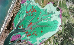
PurposeThis shapefile provides a high-resolution interpretation of the surficial geology of Apalachicola Bay, and western part of St. George Sound, Florida. The interpretation is based on the sidescan sonar imagery, the bathymetry, available sediment sample information, and seafloor observations. The initial surficial geologic interpretations have been translated by the Office for Coastal Management into the Florida System for Classifying Habitats in Estuarine and Marine Environments (SCHEME). No sediment classes were lost during this process.
Distribution Information
Controlled Theme Keywords
BENTHIC, COASTAL, environment, ESTUARY
URLs
-
Information and resources on the CMECS standard and how to apply it
-
Searchable online catalog of CMECS units, descriptions, and source references
-
The website provides not only coastal data, but also the tools, training, and information needed to make these data truly useful. Content comes from many sources, all of which are vetted by NOAA.
Child Items
| Type | Title |
|---|---|
| Entity | Biotic |
URLs
URL 1
| URL: | https://iocm.noaa.gov/cmecs |
|---|---|
| Name: | CMECS Home Page |
| URL Type: |
Online Resource
|
| Description: |
Information and resources on the CMECS standard and how to apply it |
URL 2
| URL: | http://www.cmecscatalog.org/ |
|---|---|
| Name: | CMECS Catalog |
| URL Type: |
Online Resource
|
| Description: |
Searchable online catalog of CMECS units, descriptions, and source references |
URL 3
| URL: | https://coast.noaa.gov/digitalcoast/ |
|---|---|
| Name: | NOAA's Office for Coastal Management (OCM) Digital Coast Data section |
| URL Type: |
Online Resource
|
| Description: |
The website provides not only coastal data, but also the tools, training, and information needed to make these data truly useful. Content comes from many sources, all of which are vetted by NOAA. |
URL 4
| URL: | https://coast.noaa.gov/data/Images/Collections/BenthicCover_thumbnail.jpg |
|---|---|
| Name: | Browse Graphic |
| URL Type: |
Browse Graphic
|
| File Resource Format: | JPEG |
| Description: |
Sample of benthic cover data |
URL 5
| URL: | http://pubs.usgs.gov/of/2006/1381/GIS/thumbnails/SurficialGeology.jpg |
|---|---|
| Name: | Browse Graphic |
| URL Type: |
Browse Graphic

|
| File Resource Format: | JPEG |
| Description: |
JPEG image of Surficial Geology shapefile |
Child Items
Rubric scores updated every 15m
| Type | Title |
|---|---|
| Entity | Biotic |