Benthic Habitats of Florida Bay, FL 1991-1995 Geodatabase
Data Set (DS) | Office for Coastal Management (OCM)GUID: gov.noaa.nmfs.inport:47891 | Updated: May 30, 2023 | Published / External
Summary
Short Citation
Office for Coastal Management, 2025: Benthic Habitats of Florida Bay, FL 1991-1995 Geodatabase, https://www.fisheries.noaa.gov/inport/item/47891.
Full Citation Examples
In the winter of 1991/92 the National Oceanic and Atmospheric Administration's Office for Coastal Management's Coastal Change Analysis Program (C-CAP) and the State of Florida commissioned the National Ocean Service's Photogrammetry Unit, the National Geodetic Survey (NGS), to acquire conventional color metric aerial photography of Florida Bay suitable for interpretation of photic benthic habitats (scale of 1:48,000). Additional photography was acquired by NGS in 1995 to cover areas of the bay that were not interpretable due to turbidity and glare during the original mission. The imagery was collected according to stringent parameters detailed in the C-CAP protocol (https://coast.noaa.gov/crs/lca/ccap.html). The original photographic diapositives were interpreted by two ecologists, familiar with the local environment. The benthic signatures were interpreted from the photography using Bausch and Lomb Zoom Stereoscopes and Richards Light Tables. The boundaries of each unique signature were delineated on acetate overlays and assigned one of 20 habitat classes. Only the central 'sweet spot' of each frame was interpreted to minimize the effects of sun glint. An ecologist at the Florida Marine Research Institute (FMRI) conducted thematic quality assurance and control. Following interpretation, Office for Coastal Management staff scanned the aerial photos, with the interpreted acetate overlays attached, using a photogrammetric quality scanner (AGFA Horizon Plus) at a resolution of 600 dpi resulting in a pixel resolution of 2.03 meters. The resulting image file was rectified (second order bilinear interpolation) using ERDAS Imagine software. Ground control points were selected from features common to digital orthophotoquads of Florida Bay. The interpreted polygon habitats were digitized into an ARC coverage from the rectified files using ERDAS Imagine software's vector module. In 1999, the final edits and quality control of the habitat polygons were completed. The coverage and shoreline were edge matched to the Benthic Habitats of the Florida Keys Atlas to complete the coverage, as the dates of photography, methodology and classification system used were the same.
Original contact information:
Contact Org: NOAA Office for Coastal Management
Phone: 843-740-1202
Email: coastal.info@noaa.gov
PurposeLoss of seagrass beds, persistent phytoplankton blooms, and elevated turbidity are symptoms of major ecological changes in Florida Bay. These changes threaten important fisheries associated with Florida Bay and the adjacent Florida Keys. Marine and estuarine seagrass beds are vital linkages in the ecosystem of Florida Bay and are essential for the maintenance of healthy fish populations. These beds cycle nutrients and stabilize the sediments as well as provide direct benefits to fisheries in the form of food and shelter. In addition, seagrass beds are connected to other ecologically and economically valuable systems, such as mangrove, coral reef and continental shelf communities. Quantification of the status and recent change in the spatial distribution of seagrass is central to understanding the distribution and extent of these declines and to guide research and management efforts.
Distribution Information
Controlled Theme Keywords
BENTHIC, COASTAL, environment, ESTUARY
URLs
-
Information and resources on the CMECS standard and how to apply it
-
Searchable online catalog of CMECS units, descriptions, and source references
-
The website provides not only coastal data, but also the tools, training, and information needed to make these data truly useful. Content comes from many sources, all of which are vetted by NOAA.
-
Information on the NOAA Office for Coastal Management (OCM)
Child Items
No Child Items for this record.
URLs
URL 1
| URL: | https://iocm.noaa.gov/cmecs |
|---|---|
| Name: | CMECS Home Page |
| URL Type: |
Online Resource
|
| Description: |
Information and resources on the CMECS standard and how to apply it |
URL 2
| URL: | http://www.cmecscatalog.org/ |
|---|---|
| Name: | CMECS Catalog |
| URL Type: |
Online Resource
|
| Description: |
Searchable online catalog of CMECS units, descriptions, and source references |
URL 3
| URL: | https://coast.noaa.gov/digitalcoast/ |
|---|---|
| Name: | NOAA's Office for Coastal Management (OCM) Digital Coast Data section |
| URL Type: |
Online Resource
|
| Description: |
The website provides not only coastal data, but also the tools, training, and information needed to make these data truly useful. Content comes from many sources, all of which are vetted by NOAA. |
URL 4
| URL: | https://coast.noaa.gov/ |
|---|---|
| Name: | NOAA's Office for Coastal Management (OCM) website |
| URL Type: |
Online Resource
|
| Description: |
Information on the NOAA Office for Coastal Management (OCM) |
URL 5
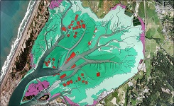
| URL: | https://coast.noaa.gov/data/Images/Collections/BenthicCover_thumbnail.jpg |
|---|---|
| Name: | Browse Graphic |
| URL Type: |
Browse Graphic
|
| File Resource Format: | JPEG |
| Description: |
Sample of benthic cover data |