Benthic Habitat Mapping - Indian River Lagoon, Florida Submerged Aquatic Vegetation (SAV) Data 1996 Geodatabase
Data Set (DS) | Office for Coastal Management (OCM)GUID: gov.noaa.nmfs.inport:47895 | Updated: May 30, 2023 | Published / External
Summary
Short Citation
Office for Coastal Management, 2025: Benthic Habitat Mapping - Indian River Lagoon, Florida Submerged Aquatic Vegetation (SAV) Data 1996 Geodatabase, https://www.fisheries.noaa.gov/inport/item/47895.
Full Citation Examples
The NOAA Office for Coastal Management's Coastal Change Analysis Program, in cooperation with the St. Johns River and South Florida Water Management Districts, used the C-CAP protocol to map SAV and other benthic habitat in Indian River. The project incorporated underwater videography, field point observations, and transect data. Analytical photogrammetry was used to accomplish the mapping. The benthic data is classified according to the System for Classification of Habitats in Estuarine and Marine Environments (SCHEME). This system is fully described in "Development of a System for Classification of Habitats in Estuarine and Marine Environments (SCHEME) for Florida, Report to U.S. EPA - Gulf of Mexico Program, Florida Fish and Wildlife Conservation Commission, Florida Marine Research Institute.Review Draft 12/04/02."
Original contact information:
Contact Org: NOAA Office for Coastal Management
Phone: 843-740-1202
Email: coastal.info@noaa.gov
Distribution Information
Controlled Theme Keywords
BENTHIC, COASTAL, environment, ESTUARY
Child Items
No Child Items for this record.
URLs
URL 1
| URL: | https://iocm.noaa.gov/cmecs |
|---|---|
| Name: | CMECS Home Page |
| URL Type: |
Online Resource
|
| Description: |
Information and resources on the CMECS standard and how to apply it |
URL 2
| URL: | http://www.cmecscatalog.org/ |
|---|---|
| Name: | CMECS Catalog |
| URL Type: |
Online Resource
|
| Description: |
Searchable online catalog of CMECS units, descriptions, and source references |
URL 3
| URL: | https://coast.noaa.gov/digitalcoast/ |
|---|---|
| Name: | NOAA's Office for Coastal Management (OCM) Digital Coast Data section |
| URL Type: |
Online Resource
|
| Description: |
The website provides not only coastal data, but also the tools, training, and information needed to make these data truly useful. Content comes from many sources, all of which are vetted by NOAA. |
URL 4
| URL: | https://coast.noaa.gov/ |
|---|---|
| Name: | NOAA's Office for Coastal Management (OCM) website |
| URL Type: |
Online Resource
|
| Description: |
Information on the NOAA Office for Coastal Management (OCM) |
URL 5
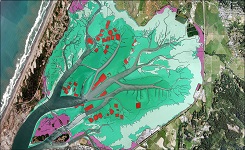
| URL: | https://coast.noaa.gov/data/Images/Collections/BenthicCover_thumbnail.jpg |
|---|---|
| Name: | Browse Graphic |
| URL Type: |
Browse Graphic
|
| File Resource Format: | JPEG |
| Description: |
Sample of benthic cover data |