Coastal Massachusetts Submerged Aquatic Beds 1994-1996 Geodatabase
Data Set (DS) | Office for Coastal Management (OCM)GUID: gov.noaa.nmfs.inport:47899 | Updated: May 30, 2023 | Published / External
Summary
Short Citation
Office for Coastal Management, 2025: Coastal Massachusetts Submerged Aquatic Beds 1994-1996 Geodatabase, https://www.fisheries.noaa.gov/inport/item/47899.
Full Citation Examples
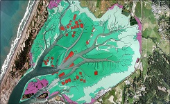
The Coastal Change Analysis Program (C-CAP) at NOAA Office for Coastal Management partnered with The Massachusetts Department of Environmental Protection Wetlands Conservancy Program (DEP-WCP) and Office of Coastal Zone Management (CZM) to produce a digital coverage of submerged aquatic vegetation, primarily eelgrass (Zostera marina) along the Atlantic coast of Massachusetts. Conventional color metric aerial photography at a scale of 1:20,000 was acquired form 1994-1996 according to stringent parameters detailed in the C-CAP protocol (https://coast.noaa.gov/crs/lca/ccap.html). The photography was photointerpreted by DEP-WCP using a biocular stereoscope (Cartographic Engineering Modular Stereoscope Model SB 190). Polygons of eelgrass were delineated onto acetate overlays affixed to each photograph. Extensive fieldwork was conducted to develop signatures and gather surface level data where the presence or extent of habitat was not apparent from the photography. An underwater video camera was utilized in this effort. The aerial photos, with the interpreted acetates attached, were scanned using a photogrammetric quality scanner (AGFA Horizon Plus) at a resolution of 600 dpi resulting in a pixel resolution of .85 meters. The resulting image file was rectified (bilinear 2nd order) by C-CAP to 1 meter black and white and color digital orthophotos supplied by CZM. The polygon delineation from the rectified image was then digitized onscreen. In addition, a point file was generated based on field-verified sites as well as all occurrences of widgeon grass (Ruppia maritima) and algae. The rectification and digitization was completed utilizing the ERDAS Imagine software package. The benthic data is classified according to the System for Classification of Habitats in Estuarine and Marine Environments (SCHEME). This system is fully described in "Development of a System for Classification of Habitats in Estuarine and Marine Environments (SCHEME) for Florida, Report to U.S. EPA - Gulf of Mexico Program, Florida Fish and Wildlife Conservation Commission, Florida Marine Research Institute. Review Draft 12/04/02." The polygon vector coverage was accuracy assessed by C-CAP and DEP-WCP in July 1997 and September 1998. The assessment was based on random points generated within the polygon boundaries. Navigation to each point in the field was accomplished using real time differential GPS. The underwater video camera was used to verify the presence of the mapped feature at the random point. The accuracy of the mapped grass was 85.4 % (175 of 205 sites mapped correct).
Original contact information:
Contact Org: NOAA Office for Coastal Management
Phone: 843-740-1202
Email: coastal.info@noaa.gov
PurposeProvide a baseline digital map of submerged aquatic vegetation resources for coastal management applications.
Distribution Information
Controlled Theme Keywords
BENTHIC, COASTAL, environment, ESTUARY
URLs
-
Information and resources on the CMECS standard and how to apply it
-
Searchable online catalog of CMECS units, descriptions, and source references
-
The website provides not only coastal data, but also the tools, training, and information needed to make these data truly useful. Content comes from many sources, all of which are vetted by NOAA.
-
Information on the NOAA Office for Coastal Management (OCM)
Child Items
No Child Items for this record.
URLs
URL 1
| URL: | https://iocm.noaa.gov/cmecs |
|---|---|
| Name: | CMECS Home Page |
| URL Type: |
Online Resource
|
| Description: |
Information and resources on the CMECS standard and how to apply it |
URL 2
| URL: | http://www.cmecscatalog.org/ |
|---|---|
| Name: | CMECS Catalog |
| URL Type: |
Online Resource
|
| Description: |
Searchable online catalog of CMECS units, descriptions, and source references |
URL 3
| URL: | https://coast.noaa.gov/digitalcoast/ |
|---|---|
| Name: | NOAA's Office for Coastal Management (OCM) Digital Coast Data section |
| URL Type: |
Online Resource
|
| Description: |
The website provides not only coastal data, but also the tools, training, and information needed to make these data truly useful. Content comes from many sources, all of which are vetted by NOAA. |
URL 4
| URL: | https://coast.noaa.gov/ |
|---|---|
| Name: | NOAA's Office for Coastal Management (OCM) website |
| URL Type: |
Online Resource
|
| Description: |
Information on the NOAA Office for Coastal Management (OCM) |
URL 5
| URL: | https://coast.noaa.gov/data/Images/Collections/BenthicCover_thumbnail.jpg |
|---|---|
| Name: | Browse Graphic |
| URL Type: |
Browse Graphic
|
| File Resource Format: | JPEG |
| Description: |
Sample of benthic cover data |