Submerged Aquatic Vegetation of Bogue Sound, North Carolina 1992 Biotic
Data Set (DS) | Office for Coastal Management (OCM)GUID: gov.noaa.nmfs.inport:47913 | Updated: May 30, 2023 | Published / External
Summary
Short Citation
Office for Coastal Management, 2025: Submerged Aquatic Vegetation of Bogue Sound, North Carolina 1992 Biotic, https://www.fisheries.noaa.gov/inport/item/47913.
Full Citation Examples
During 1992, 1:20,000 scale aerial photography for Bogue Sound, North Carolina was collected as part of an effort to map submerged aquatic vegetation (SAV) in Coastal North Carolina. The imagery was collected following a strict set of guidelines as detailed in NOAA Coastal Change Analysis Program (C-CAP): Guidance for Regional Implementation (NOAA Technical Report NMFS 123 1995; see Chapter 4 online at www.coast.noaa.gov/crs/lca/methods.html). Photographs were taken at low tide and during times that the growth stage of the SAV allowed for clear identification. Care was taken to minimize the effects of turbidity, sun glint, wind, and haze on the photos. The imagery was scanned using a photogrammetric quality scanner (AGFA Horizon Plus) at a resolution of 600 dots per inch (dpi) resulting in a pixel resolution of 0.85 meters. Signature development took place during the summer of 2001. The images were orthorectified using ground control points selected from the state digital orthoquads and the National Imagery and Mapping Agency (NIMA) Digital Terrain Elevation Data (DTED(r)). The benthic data is classified according to the System for Classification of Habitats in Estuarine and Marine Environments (SCHEME). This system is fully described in "Development of a System for Classification of Habitats in Estuarine and Marine Environments (SCHEME) for Florida, Report to U.S. EPA - Gulf of Mexico Program, Florida Fish and Wildlife Conservation Commission, Florida Marine Research Institute. Review Draft 12/04/02." The images were interpreted and digitized on screen using ArcGIS 8.2 and labeled using ArcView 3.2 and the Benthic Habitat Digitizer extension (developed by the NOS Biogeography Program). The data have not been assessed for thematic accuracy due to the large disparity between dates of image acquisition in 1992 and interpretation in 2002. The data was assessed for horizontal spatial accuracy and thematic agreement during the fall of 2002.
Original contact information:
Contact Org: NOAA Office for Coastal Management
Phone: 843-740-1202
Email: coastal.info@noaa.gov
PurposeThis data set was developed as a baseline of SAV data for Bogue Sound, North Carolina in 1992. The SAV data will be used as a baseline for future state SAV mapping projects.
Distribution Information
Controlled Theme Keywords
BENTHIC, COASTAL, environment, ESTUARY
URLs
-
Information and resources on the CMECS standard and how to apply it
-
Searchable online catalog of CMECS units, descriptions, and source references
-
The website provides not only coastal data, but also the tools, training, and information needed to make these data truly useful. Content comes from many sources, all of which are vetted by NOAA.
-
Information on the NOAA Office for Coastal Management (OCM)
Child Items
| Type | Title |
|---|---|
| Entity | Biotic |
URLs
URL 1
| URL: | https://iocm.noaa.gov/cmecs |
|---|---|
| Name: | CMECS Home Page |
| URL Type: |
Online Resource
|
| Description: |
Information and resources on the CMECS standard and how to apply it |
URL 2
| URL: | http://www.cmecscatalog.org/ |
|---|---|
| Name: | CMECS Catalog |
| URL Type: |
Online Resource
|
| Description: |
Searchable online catalog of CMECS units, descriptions, and source references |
URL 3
| URL: | https://coast.noaa.gov/digitalcoast/ |
|---|---|
| Name: | NOAA's Office for Coastal Management (OCM) Digital Coast Data section |
| URL Type: |
Online Resource
|
| Description: |
The website provides not only coastal data, but also the tools, training, and information needed to make these data truly useful. Content comes from many sources, all of which are vetted by NOAA. |
URL 4
| URL: | https://coast.noaa.gov/ |
|---|---|
| Name: | NOAA's Office for Coastal Management (OCM) website |
| URL Type: |
Online Resource
|
| Description: |
Information on the NOAA Office for Coastal Management (OCM) |
URL 5
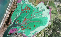
| URL: | https://coast.noaa.gov/data/Images/Collections/BenthicCover_thumbnail.jpg |
|---|---|
| Name: | Browse Graphic |
| URL Type: |
Browse Graphic
|
| File Resource Format: | JPEG |
| Description: |
Sample of benthic cover data |
Child Items
Rubric scores updated every 15m
| Type | Title |
|---|---|
| Entity | Biotic |