2002 Long Island South Shore Estuary Benthic Habitat Polygon Data Set Geodatabase
Data Set (DS) | Office for Coastal Management (OCM)GUID: gov.noaa.nmfs.inport:47939 | Updated: May 30, 2023 | Published / External
Summary
Short Citation
Office for Coastal Management, 2024: 2002 Long Island South Shore Estuary Benthic Habitat Polygon Data Set Geodatabase, https://www.fisheries.noaa.gov/inport/item/47939.
Full Citation Examples
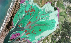
In June 2002, 200 1:20,000 scale conventional-color metric film diapositives for Long Island, New York were collected as part of an effort to map submerged aquatic vegetation (SAV) in Long Islands South Shore bays. They were provided by New York State Department of State's Division of Coastal Resources. Photographs were taken at low tide and during times that the growth stage of the SAV allowed for clear identification. Care was taken to minimize the effects of turbidity, sun glint, wind, and haze on the photos. The photos were scanned at a resolution of 15 microns. Ground control points were collected primarily from NYSDS 2 ft orthophotos. Additional control points were collected from USGS DOQQs where coverage from the primary source was lacking. All elevations were derived from USGS digital elevation models. A bundle block adjustment was performed using Albany and exterior orientation parameters were calculated. Boeing/Autometric's Softplotter was used to orthorectify the photos. The images were then dodged and mosaicked using Z/I's Orthopro. No additional color-balancing was performed as the mosaic's intended purpose was the delineation of benthic habitats. The mosaic was then output into 1000m by 1000m tiles with a 0.5m pixel resolution. The naming convention uses the first 3 numbers of the UTM x coordinate followed by the first 4 numbers in the UTM y coordinate of the southwest corner. Stereo digital images were created and the habitat features were interpreted and digitized on screen using softplotter microstation resulting in accurate and efficient 3D extraction of the data. Habitats were delineated with a high level of detail with the minimum mapping unit (MMU) being 0.01 hectares(approx.10m x 10m).The digitized polygons have the following specifications: Vertex Distance less than 1.0 m Node Snap Distance less than 4.0 m Arc Snap Distance less than 4.0 m During August 2002, NOAA staff collected 95 field observations throughout the study area and this information was incorporated into the map. In June 2003, after reviewing the photography, questionable areas were visited by Greenhorne and O'Mara staff and the findings were subsequently applied to the map. The map layers show delineated polygons and lines representing benthic habitat data. Each polygon feature is given a 1,2,3 or 4 digit number representing 11 habitats. The item numbers are stored in the attribute table under Text. The benthic data is classified according to the System for Classification of Habitats in Estuarine and Marine Environments (SCHEME). This system is fully described in "Development of a System for Classification of Habitats in Estuarine and Marine Environments (SCHEME) for Florida, Report to U.S. EPA - Gulf of Mexico Program, Florida Fish and Wildlife Conservation Commission, Florida Marine Research Institute. Review Draft 12/04/02."The collected data was converted to an ARCGIS format for quality control and delivery. The data was assessed for horizontal spatial accuracy and thematic agreement during 2003.
Original contact information:
Contact Org: NOAA Office for Coastal Management
Phone: 843-740-1202
Email: coastal.info@noaa.gov
Distribution Information
-
FTP download of data files.
Data is available upon request
None
Controlled Theme Keywords
BENTHIC, COASTAL, environment, ESTUARY
Child Items
No Child Items for this record.
URLs
URL 1
| URL: | https://iocm.noaa.gov/cmecs |
|---|---|
| Name: | CMECS Home Page |
| URL Type: |
Online Resource
|
| Description: |
Information and resources on the CMECS standard and how to apply it |
URL 2
| URL: | http://www.cmecscatalog.org/ |
|---|---|
| Name: | CMECS Catalog |
| URL Type: |
Online Resource
|
| Description: |
Searchable online catalog of CMECS units, descriptions, and source references |
URL 3
| URL: | https://coast.noaa.gov/digitalcoast/ |
|---|---|
| Name: | NOAA's Office for Coastal Management (OCM) Digital Coast Data section |
| URL Type: |
Online Resource
|
| Description: |
The website provides not only coastal data, but also the tools, training, and information needed to make these data truly useful. Content comes from many sources, all of which are vetted by NOAA. |
URL 4
| URL: | https://coast.noaa.gov/ |
|---|---|
| Name: | NOAA's Office for Coastal Management (OCM) website |
| URL Type: |
Online Resource
|
| Description: |
Information on the NOAA Office for Coastal Management (OCM) |
URL 5
| URL: | https://coast.noaa.gov/data/Images/Collections/BenthicCover_thumbnail.jpg |
|---|---|
| Name: | Browse Graphic |
| URL Type: |
Browse Graphic
|
| File Resource Format: | JPEG |
| Description: |
Sample of benthic cover data |