Coastal Bend Texas Benthic Habitat - Lower Laguna Madre 2004 Geoform
Data Set (DS) | Office for Coastal Management (OCM)GUID: gov.noaa.nmfs.inport:47969 | Updated: April 30, 2025 | Published / External
Summary
Short Citation
Office for Coastal Management, 2025: Coastal Bend Texas Benthic Habitat - Lower Laguna Madre 2004 Geoform, https://www.fisheries.noaa.gov/inport/item/47969.
Full Citation Examples
In 2006 and 2007 the NOAA Office for Coastal Management purchased services to process existing digital multi-spectral imagery (ADS-40) and create digital benthic habitat data from this imagery for selected Texas coastal bend bays. The Center worked cooperatively with the Texas Parks and Wildlife Department (TPWD) and the Texas A&M University Center for Coastal Studies to develop benthic habitat data, primarily Submerged Aquatic Vegetation (SAV) for several coastal bays. This data will support the state's recently adopted Seagrass Monitoring Program which calls for regional mapping of SAV for status and trends assessment. The Center, Texas A&M, and TPWD have coordinated on the requirements of this project.
Original contact information:
Contact Org: NOAA Office for Coastal Management
Phone: 843-740-1202
Email: coastal.info@noaa.gov
PurposeThese data have been created as a result of the need for having geospatial data immediately available and easily accessible in order to enhance the capability of the NOAA Office for Coastal Management (OCM)
Distribution Information
Controlled Theme Keywords
BENTHIC, COASTAL, environment, ESTUARY
URLs
-
Information and resources on the CMECS standard and how to apply it
-
Searchable online catalog of CMECS units, descriptions, and source references
-
The website provides not only coastal data, but also the tools, training, and information needed to make these data truly useful. Content comes from many sources, all of which are vetted by NOAA.
Child Items
| Type | Title |
|---|---|
| Entity | Geoform |
URLs
URL 1
| URL: | https://iocm.noaa.gov/cmecs |
|---|---|
| Name: | CMECS Home Page |
| URL Type: |
Online Resource
|
| Description: |
Information and resources on the CMECS standard and how to apply it |
URL 2
| URL: | http://www.cmecscatalog.org/ |
|---|---|
| Name: | CMECS Catalog |
| URL Type: |
Online Resource
|
| Description: |
Searchable online catalog of CMECS units, descriptions, and source references |
URL 3
| URL: | https://coast.noaa.gov/digitalcoast/ |
|---|---|
| Name: | NOAA's Office for Coastal Management (OCM) Digital Coast Data section |
| URL Type: |
Online Resource
|
| Description: |
The website provides not only coastal data, but also the tools, training, and information needed to make these data truly useful. Content comes from many sources, all of which are vetted by NOAA. |
URL 4
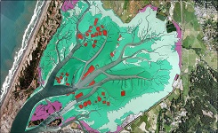
| URL: | https://coast.noaa.gov/data/Images/Collections/BenthicCover_thumbnail.jpg |
|---|---|
| Name: | Browse Graphic |
| URL Type: |
Browse Graphic
|
| File Resource Format: | JPEG |
| Description: |
Sample of benthic cover data |
Child Items
Rubric scores updated every 15m
| Type | Title |
|---|---|
| Entity | Geoform |