Determining Watershed Management Efficacy in West Maui: line-point-intercept and photo quadrat surveys of benthic communities for benthic cover from 2014 to 2015
Data Set (DS) | Pacific Islands Fisheries Science Center (PIFSC)GUID: gov.noaa.nmfs.inport:27316 | Updated: May 15, 2025 | Published / External
Summary
Short Citation
Pacific Islands Fisheries Science Center, 2025: Determining Watershed Management Efficacy in West Maui: line-point-intercept and photo quadrat surveys of benthic communities for benthic cover from 2014 to 2015, https://www.fisheries.noaa.gov/inport/item/27316.
Full Citation Examples
The focus of the Wahikuli-Honokowai Watershed Management Plan is the land use practices and alterations affected in the agricultural and urban districts that have upset the natural drainage patterns and ecohydrologic balance and services the watersheds provide. As the approach to reducing the effects of land-based sources of pollution, the Wahikuli-Honokowai Watershed Management Plan identifies nine priority projects to reduce, capture, and remediate the impacts of non-point source pollutants through the implementation of management practices in priority areas. The Watershed Management Plan also includes recommendations for strategic, long-term trend monitoring of the health of the coral reef ecosystem, which provides information that can be correlated to the implementation of solutions to reduce land-based non-point source pollutants.
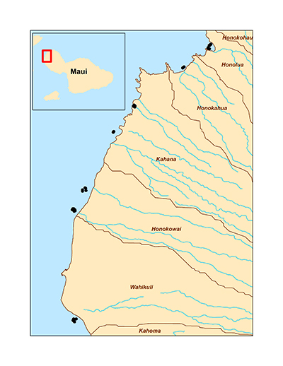
Kahekili Beach Park reef and the coastal areas to the north are considered high priority. Corals in this region have been severely impacted by land-based pollutants, causing coral dieback and reducing coral cover. To fill in the gap, a baseline assessment for benthic cover data (described here) along with coral demographic metrics, has been conducted at the mouths of the Mahinahina, Honokowai, and Wahikuli, Kahana, Honokeana, Honokohua, and Honolua stream drainages in West Maui, Hawaii, to track and evaluate the efficacy of implemented management practices. The installation of permanent survey transects will provide long-term time series to quantify changes in the reef benthic community. Sediment flux, and turbidity data are also collected at the Mahinahina, Honokowai, and Wahikuli, dranages (described separately).
The data described here were collected via line-point-intercept (LPI) and photo quadrat surveys by the NOAA Coral Reef Ecosystem Program (CREP) according to established protocols. These data include:
1) an assessment of benthic cover for the selected monitoring sites; and
2) benthic photographs to serve as a permanent record of the site.
Data is available for surveys conducted in 2014 and 2015. The LPI data can be accessed online via the NOAA National Centers for Environmental Information (NCEI) Ocean Archive, accession #0138585, and the benthic photographs are available upon request from CREP.
Additionally, belt transect surveys of coral demography (adult and juvenile corals) were conducted (described separately), and turbidity sensors, sediment traps, and sediment pods were deployed by project partners to provide information on sediment loads, sediment accumulation rates, and sediment composition. As watershed management projects are implemented, changes in sediment and nutrient loading and the resulting impacts on the reefs can be monitored over time.
Distribution Information
-
CSV - Comma Separated Values (Text), 922 KB
Benthic category data from line-point-intercept surveys conducted by the NOAA Coral Reef Ecosystem Program in West Maui, Hawaii from 2014 to 2015 (NOAA NCEI Accession #0138585).
None
Please cite NOAA Coral Reef Ecosystem Program (CREP) when using the data.
Example
Cite as: Vargas-Angel, B; Coral Reef Ecosystem Program; Pacific Islands Fisheries Science Center (2015). Determining Watershed Management Efficacy in West Maui: line-point-intercept and photo quadrat surveys of benthic communities for benthic cover from 2014 to 2015 (NCEI Accession #0138585). NOAA National Centers for Environmental Information. Unpublished Dataset. [access date]
Controlled Theme Keywords
biota
Child Items
| Type | Title |
|---|---|
| Entity | View: V0_BENT_LPI |
URLs
URL 1
| URL: | https://www.pifsc.noaa.gov/cred/corals.php |
|---|---|
| URL Type: |
Online Resource
|
| File Resource Format: | PHP |
| Description: |
NOAA Coral Reef Ecosystem Program (CREP) Ecological Assessment of Coral project page |
URL 2
| URL: | http://www.westmauir2r.com/uploads/7/5/7/6/7576120/whwmp-vol1watershed_characterization-jan_2013.pdf |
|---|---|
| URL Type: |
Online Resource
|
| File Resource Format: | |
| Description: |
Wahikuli-Honokowai Watershed Management Plan Volume 1: Watershed Characterization |
URL 3
| URL: | http://www.westmauir2r.com/uploads/7/5/7/6/7576120/whwmp_vol_2_executive_summary.pdf |
|---|---|
| URL Type: |
Online Resource
|
| File Resource Format: | |
| Description: |
Wahikuli-Honokowai Watershed Management Plan Volume 2: Executive Summary |
URL 4
| URL: | http://health.hawaii.gov/cwb/files/2013/05/WHWMP_Vol2_StrategiesImplementation_Dec2012.pdf |
|---|---|
| URL Type: |
Online Resource
|
| File Resource Format: | |
| Description: |
Wahikuli-Honokowai Watershed Management Plan Volume 2: Strategies and Implementation |
URL 5
| URL: | http://dlnr.hawaii.gov/coralreefs/files/2013/04/Wahikuli-Honokawai-Watershed-Management-Plan-Vol1-2.pdf |
|---|---|
| URL Type: |
Online Resource
|
| File Resource Format: | |
| Description: |
Wahikuli-Honokowai Watershed Management Plan Volume1: Executive Summary |
URL 6
| URL: | https://data.nodc.noaa.gov/coris/data/NOAA/nmfs/pifsc/cred/maui_watershed/BrowseGraphic_450.jpg |
|---|---|
| URL Type: |
Browse Graphic
|
| File Resource Format: | JPG |
| Description: |
Map showing locations of surveys in West Maui, Hawaii for the NOAA Coral Reef Conservation Program (CRCP) funded project, "Determining Watershed Management Efficacy in West Maui". |
Child Items
Rubric scores updated every 15m
| Type | Title |
|---|---|
| Entity | View: V0_BENT_LPI |