Dominant Benthic Structure and Biological Cover Habitat Maps for West Maui and West Hawaii
Data Set (DS) | Pacific Islands Fisheries Science Center (PIFSC)GUID: gov.noaa.nmfs.inport:32811 | Updated: August 15, 2023 | Published / External
Summary
Short Citation
Pacific Islands Fisheries Science Center, 2024: Dominant Benthic Structure and Biological Cover Habitat Maps for West Maui and West Hawaii, https://www.fisheries.noaa.gov/inport/item/32811.
Full Citation Examples
Benthic habitat maps depict dominant substrate type and biological cover in depths between 0 and ~150 m for two priority sites in the Main Hawaiian Islands; the NOAA Habitat Blueprint West Hawaii Focus Area (WHFA) and the Hawaii Division of Aquatic Resources (DAR) West Maui priority watersheds.
The primary data source for these maps was a 5-m resolution bathymetry synthesis grid, collected from a number of sources and maintained by the University of Hawaii at Manoa (UH) Hawaii Mapping Research Group (HMRG). Geomorphic derivatives of slope, slope of slope, rugosity and curvature were created from the bathymetry grid using the Benthic Terrain Modeler (https://esriurl.com/5754) in ArcGIS.
New optical seafloor imagery was collected by the NOAA Coral Reef Ecosystem Program (CREP) to produce these maps, and seafloor imagery was also provided from a number of partners including the United States Geological Survey (USGS) the Nature Conservancy, NOAA Biogeography group and the Hawaii Institute of Marine Biology. All images were visually analyzed by CREP to classify dominant substrate type and biological cover.
A Principle Component Analysis performed in ArcGIS removed highly correlated information from the suite of geomorphic surfaces derived from the bathymetry synthesis grid. This was followed by an unsupervised classification using the Iso Cluster Classification tool in ArcGIS. The resulting image was examined and manually corrected using the classification data from the analyzed seafloor imagery as validation. The resulting benthic habitat map delineates eight dominant substrates (Complex Reef, Boulder, Rubble, Mixed Substrate, Pavement, Sand, Mud, and Manmade) and six dominant biological cover types (Coral, Coralline Algae, Turf Algae, Macroalgae, Uncolonized and Unclassified) that extend from the shoreline to ~150 m.
Distribution Information
-
Zip file containing dominant substrate and dominant biological cover data (shapefile and LYR files) and maps (PDF and JPG) for the Habitat Blueprint West Hawaii Focus Area.
-
Zip file containing dominant substrate and dominant biological cover data (shapefile and LYR files) and maps (JPG and PDF) for the West Maui priority area.
None
These data are not to be used for navigation purposes.
Please cite NOAA Coral Reef Ecosystem Program (CREP) when using the data.
Suggested citation:
Coral Reef Ecosystem Program; Pacific Islands Fisheries Science Center (2016). Dominant Benthic Structure and Biological Cover Habitat Maps for West Maui and West Hawaii. https://www.fisheries.noaa.gov/inport/item/32811 [access date]
Controlled Theme Keywords
biota, oceans
Child Items
No Child Items for this record.
URLs
URL 1
| URL: | http://www.soest.hawaii.edu/pibhmc/index.htm |
|---|---|
| URL Type: |
Online Resource
|
| File Resource Format: | HTML |
| Description: |
Pacific Islands Benthic Habitat Mapping Center (PIBHMC) website. All data are accessible through this website. |
URL 2
| URL: | http://www.westmauir2r.com/uploads/7/5/7/6/7576120/4112068.jpg?324 |
|---|---|
| URL Type: |
Browse Graphic
|
| File Resource Format: | jpg |
| Description: |
West Maui Ridge to Reef Area, including the 5 priority watersheds within West Maui. |
URL 3
| URL: | https://www.habitatblueprint.noaa.gov/habitat-focus-areas/west-hawaii/ |
|---|---|
| URL Type: |
Online Resource
|
| File Resource Format: | HTML |
| Description: |
NOAA Habitat Blueprint West Hawaii Focus Area website |
URL 4
| URL: | https://www.habitatblueprint.noaa.gov/storymap/hfa/hfa_pages/images/westHawaii/location_map.jpg |
|---|---|
| URL Type: |
Browse Graphic
|
| File Resource Format: | JPG |
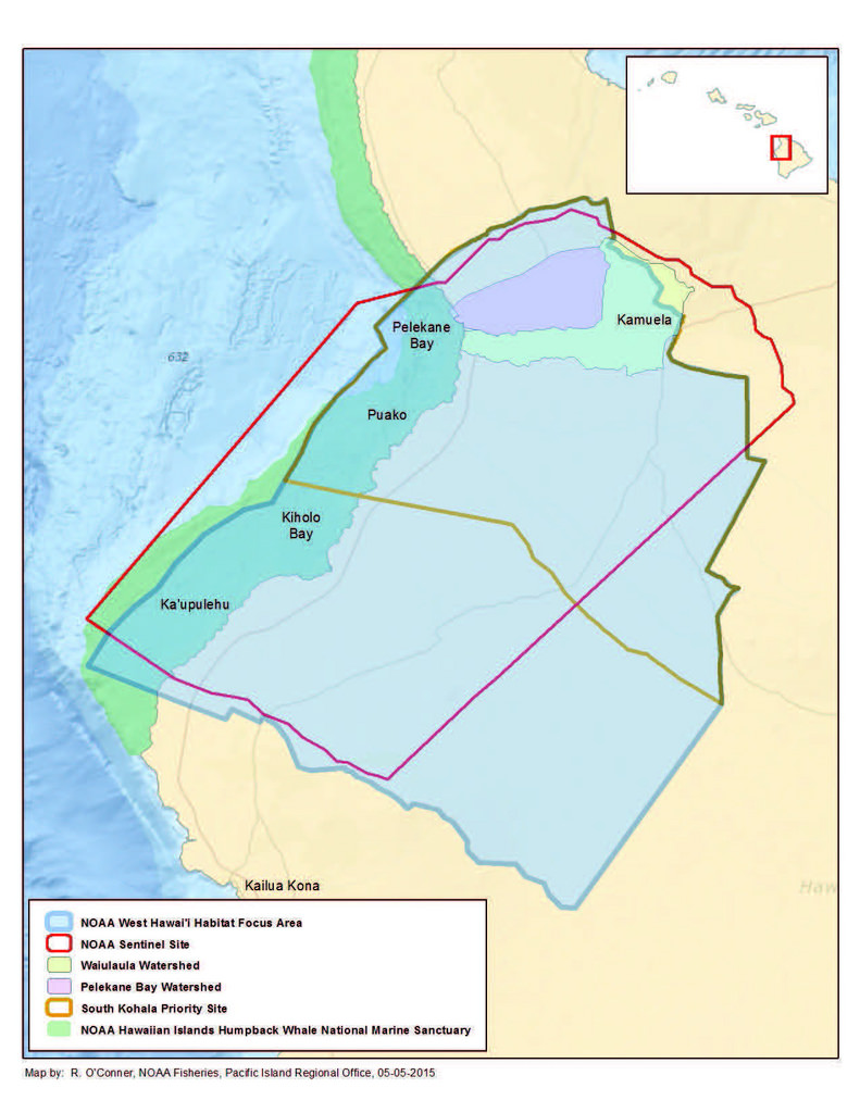
| Description: |
NOAA Habitat Blueprint West Hawaii Focus Area |
URL 5
| URL: | http://www.westmauir2r.com/ |
|---|---|
| URL Type: |
Online Resource
|
| File Resource Format: | HTML |
| Description: |
West Maui Ridge to Reef Initiative |