Assessment of Existing Information for Atlantic Coastal Fish Habitat Partnership (ACFHP)
Data Set (DS) | National Centers for Coastal Ocean Science (NCCOS)GUID: gov.noaa.nmfs.inport:38725 | Updated: May 15, 2025 | Published / External
Summary
Short Citation
National Centers for Coastal Ocean Science, 2025: Assessment of Existing Information for Atlantic Coastal Fish Habitat Partnership (ACFHP), https://www.fisheries.noaa.gov/inport/item/38725.
Full Citation Examples
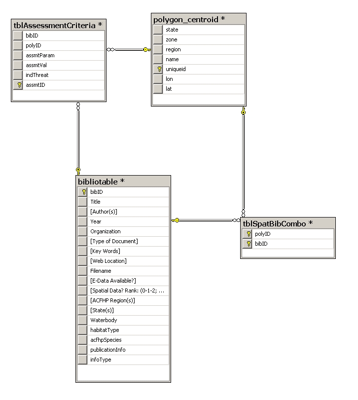
The ACFHP database consist of three primary data tables, joined within SQL Server, a relational DBMS: 1. The Bibliographic table provides information on over 500 selected documents and data sources on Atlantic coastal fish species and habitats. 2. The Assessment table provides information on habitat condition indicators, threats, and conservation actions. 3. The Geospatial table provides location references for information recorded in the Bibliography and Assessment tables. In addition, a separate table enables the many-to-many relationship between bibliographic entries and locations.
PurposeThe Atlantic Coastal Fish Habitat Database provides the Atlantic Coastal Fish Habitat Partnership (ACFHP) with the capability to review and summarize existing information on Indicators, Threats, and Conservation Actions, to inform strategic conservation planning for estuarine and marine coastal waters and watersheds. It can also be used for other purposes, including the National Fish Habitat Action Plan (NFHAP) 2010 Assessment.
Distribution Information
-
XLS - Microsoft Excel, 1.0
Downloadable Data
None
None
Controlled Theme Keywords
biota, environment, inlandWaters, oceans
Child Items
| Type | Title |
|---|---|
| Entity | Assessment Table |
| Entity | Bibliographic Table |
| Entity | Geospatial Table |
URLs
URL 1
| URL: | https://coastalscience.noaa.gov/projects/detail?key=46 |
|---|---|
| URL Type: |
Online Resource
|
URL 2
| URL: | https://nccospublicstor.blob.core.windows.net/projects-attachments/46/NFHAP_ACFHP_browse_graphic.jpg |
|---|---|
| URL Type: |
Browse Graphic
|
| File Resource Format: | JPEG |
| Description: |
NFHAP_ACFHP_browse_graphic.jpg (125kb) provides an illustration of the ACFHP database design. The Assessment table is linked to the Bibliographic Table by the bibID field. The two are also linked by a many-to-many relationship of Waterbody Number (uniqueid). The AssessmentTable is also linked to the Geospatial Table by the uniqueid (Waterbody Number) field. |
Child Items
Rubric scores updated every 15m
| Type | Title |
|---|---|
| Entity | Assessment Table |
| Entity | Bibliographic Table |
| Entity | Geospatial Table |