Humboldt Bay Benthic Habitats 2009 Aquatic Setting
Data Set (DS) | Office for Coastal Management (OCM)GUID: gov.noaa.nmfs.inport:47851 | Updated: May 30, 2023 | Published / External
Summary
Short Citation
Office for Coastal Management, 2025: Humboldt Bay Benthic Habitats 2009 Aquatic Setting, https://www.fisheries.noaa.gov/inport/item/47851.
Full Citation Examples
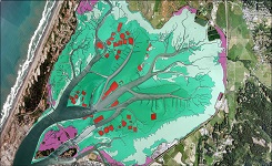
Humboldt Bay is the largest estuary in California north of San Francisco Bay and represents a significant resource for the north coast region. Beginning in 2007 the Coastal Services Center began collaborating with the California SeaGrant program and other local partners to support an ecosystem-based management (EBM) project for Humboldt Bay. One element of this project was to develop subtidal habitat goals for the long-term management of the bay and provide a framework for conservation and management across the land-sea interface. An aerial imagery-based mapping effort was conducted between 2008 and 2010 which produced a shallow benthic habitat map classified using the Florida System for Classifying Habitats in Estuarine and Marine Environments (SCHEME) system. This effort resulted in a single polygon shapefile which was later converted to the Coastal and Marine Ecological Classification Standard (CMECS)classification and organized into separate feature layers for three CMECS components; geoform, substrate, and biotic. Aquatic setting layers (#1 and #2) were produced to further populate the CMECS data structure. Ancillary data was used to accomplish this process in 2015.
Original contact information:
Contact Org: NOAA Office for Coastal Management
Phone: 843-740-1202
Email: coastal.info@noaa.gov
PurposeThe data was developed to support ecosystem based management in the Humboldt Bay region. The focus of the mapping was on shallow water benthic habitats with particular concern for eelgrass meadows. This aquatic setting layer was developed to further populate the CMECS structure and to serve as an example data set for other CMECS users.
Distribution Information
Controlled Theme Keywords
BENTHIC, COASTAL, environment, ESTUARY
URLs
-
Information and resources on the CMECS standard and how to apply it
-
Searchable online catalog of CMECS units, descriptions, and source references
-
The website provides not only coastal data, but also the tools, training, and information needed to make these data truly useful. Content comes from many sources, all of which are vetted by NOAA.
-
Information on the NOAA Office for Coastal Management (OCM)
Child Items
| Type | Title |
|---|---|
| Entity | Aquatic Setting |
URLs
URL 1
| URL: | https://iocm.noaa.gov/cmecs |
|---|---|
| Name: | CMECS Home Page |
| URL Type: |
Online Resource
|
| Description: |
Information and resources on the CMECS standard and how to apply it |
URL 2
| URL: | https://www.cmecscatalog.org/ |
|---|---|
| Name: | CMECS Catalog |
| URL Type: |
Online Resource
|
| Description: |
Searchable online catalog of CMECS units, descriptions, and source references |
URL 3
| URL: | https://coast.noaa.gov/digitalcoast/ |
|---|---|
| Name: | NOAA's Office for Coastal Management (OCM) Digital Coast Data section |
| URL Type: |
Online Resource
|
| Description: |
The website provides not only coastal data, but also the tools, training, and information needed to make these data truly useful. Content comes from many sources, all of which are vetted by NOAA. |
URL 4
| URL: | https://www.coast.noaa.gov/ |
|---|---|
| Name: | NOAA's Office for Coastal Management (OCM) website |
| URL Type: |
Online Resource
|
| Description: |
Information on the NOAA Office for Coastal Management (OCM) |
URL 5
| URL: | https://coast.noaa.gov/data/Images/Collections/BenthicCover_thumbnail.jpg |
|---|---|
| Name: | Browse Graphic |
| URL Type: |
Browse Graphic
|
| File Resource Format: | JPEG |
| Description: |
Sample of benthic cover data |
Child Items
Rubric scores updated every 15m
| Type | Title |
|---|---|
| Entity | Aquatic Setting |