Search Help Show/Hide Menu
Summary
Item Identification
Keywords
Physical Location
Data Set Info
Support Roles
Extents
Access Info
Distribution Info
URLs
Data Quality
Data Management
Lineage
Acquisition Info
Child Items
Related Items
Catalog Details

Summary

Map of Kahekili Herbivore Fishery Management Area

Short Citation
Pacific Islands Fisheries Science Center, 2024: Benthic Imagery from the Kahekili Herbivore Fisheries Management Area (HFMA), https://www.fisheries.noaa.gov/inport/item/64552.
Full Citation Examples

DOI: https://doi.org/10.7289/v5js9nr4

Abstract

Photoquadrat benthic images were collected within the Kahekili Herbivore Fisheries Management Area (HFMA) in West Maui by the Pacific Islands Fisheries Science Center (PIFSC) Ecosystem Sciences Division (ESD; formerly the Coral Reef Ecosystem Division) for quantifying benthic composition.

This metadata record is for the source imagery of the benthic cover data produced using CoralNet which is part of a separate accession and metadata record (see 'Related Items' is below, link: https://www.fisheries.noaa.gov/inport/item/30951). The images can be linked to the benthic cover by site number in each image filename (file naming convention for each photo/image is KA[YEAR][MONTH]_[SURVEY#]_[GenericImageName]);the sites are described in the site metadata file provided. All data are accessible via the NOAA National Centers for Environmental Information (NCEI) Ocean Archive.

Benthic cover (%) was extracted from photoquadrats where 25 photographs were taken at 1m intervals along a 30-m long transect. The resulting imagery at each site was analyzed using a web-based annotation tool called CoralNet where the benthic composition was defined for 15 points per photoquadrat.

Distribution Information

  • JPEG

    Photoquadrat benthic images collected at Kahekili Herbivore Fisheries Management Area (KHFMA), Maui by the NOAA Ecosystem Sciences Division (ESD).

    Images are all in a single folder and organized by name only KA-[ROUND]-[ARBITRARY_SITE_NAME]_[GENERIC_IMAGE_NAME], e.g. KA2111_084_IMG_01.JPG.

  • CSV - Comma Separated Values (Text)

    This metadata file is a list of the sites analyzed, by which the images are named (the imagery naming convention: KA-[ROUND]-[ARBITRARY_SITE_NAME]_[GENERIC_IMAGE_NAME]). This links the source imagery to the benthic cover dataset.

    For example:

    Image name: KA2111_084_IMG_01 has site name is '084'; one can find this site information in the site metadata file as well as with site name in benthic cover data produced with CoralNet, whose metadata record and accession are available under 'Related Items'.

  • CSV - Comma Separated Values (Text)

    Data dictionary for provided site metadata.

Access Constraints:

None

Use Constraints:

Please cite NOAA Fisheries, Ecosystem Sciences Division (ESD) when using the data.

Example:

Ecosystem Sciences Division; Pacific Islands Fisheries Science Center (2021). Benthic Imagery from the Kahekili Herbivore Fisheries Management Area (HFMA), https://www.fisheries.noaa.gov/inport/item/36152.

Controlled Theme Keywords

biota

Child Items

Type Title
Entity KahekiliSiteMetadata_DataDictionary

Contact Information

Metadata Contact
Lori H Luers
lori.luers@noaa.gov

Metadata Contact
Brooke Olenski
brooke.olenski@noaa.gov

Extents

Geographic Area 1

-156.6983° W, -156.6867° E, 20.9542° N, 20.9263° S

Extent of Kahekili Marine Reserve

Time Frame 1
2021-03-01 - 2021-11-11

Time frame of underwater surveys conducted in the Kahekili Herbivore Fisheries Management Area in March and November 2021

Item Identification

Title: Benthic Imagery from the Kahekili Herbivore Fisheries Management Area (HFMA)
Status: On Going
Creation Date: 2021-03
Revision Date: 2021-08
Publication Date: 2022
Abstract:

Photoquadrat benthic images were collected within the Kahekili Herbivore Fisheries Management Area (HFMA) in West Maui by the Pacific Islands Fisheries Science Center (PIFSC) Ecosystem Sciences Division (ESD; formerly the Coral Reef Ecosystem Division) for quantifying benthic composition.

This metadata record is for the source imagery of the benthic cover data produced using CoralNet which is part of a separate accession and metadata record (see 'Related Items' is below, link: https://www.fisheries.noaa.gov/inport/item/30951). The images can be linked to the benthic cover by site number in each image filename (file naming convention for each photo/image is KA[YEAR][MONTH]_[SURVEY#]_[GenericImageName]);the sites are described in the site metadata file provided. All data are accessible via the NOAA National Centers for Environmental Information (NCEI) Ocean Archive.

Benthic cover (%) was extracted from photoquadrats where 25 photographs were taken at 1m intervals along a 30-m long transect. The resulting imagery at each site was analyzed using a web-based annotation tool called CoralNet where the benthic composition was defined for 15 points per photoquadrat.

Purpose:

In 2009, the state of Hawaii established the Kahekili Herbivore Fisheries Management Area (HFMA) in West Maui. Fishing for herbivores (parrotfishes, surgeonfishes, chubs, sea urchins) is prohibited, as the goal is to use this form of marine management to promote ecosystem resilience of coral reefs by naturally maintaining macroalgae at low levels to prevent it from dominating over corals. The data described herein are part of an ongoing monitoring program used to assess changes in fish and benthic assemblages since the HFMA was implemented.

The NOAA Coral Reef Conservation Program (CRCP) has provided support for ESD staff to assist the Hawaii Department of Land and Natural Resources (DLNR) Division of Aquatic Resources (DAR) staff with maintaining long-term biological monitoring of the HFMA.

DOI (Digital Object Identifier): https://doi.org/10.7289/v5js9nr4
DOI Registration Authority: NOAA

Keywords

Theme Keywords

Thesaurus Keyword
ISO 19115 Topic Category
biota
UNCONTROLLED
CoRIS Discovery Thesaurus Visual Images > Habitats
CoRIS Theme Thesaurus EARTH SCIENCE > Biosphere > Aquatic Habitat > Benthic Habitat
CoRIS Theme Thesaurus EARTH SCIENCE > Biosphere > Aquatic Habitat > Reef Habitat
CoRIS Theme Thesaurus EARTH SCIENCE > Biosphere > Zoology > Corals
CoRIS Theme Thesaurus EARTH SCIENCE > Biosphere > Zoology > Corals > Reef Monitoring and Assessment
CoRIS Theme Thesaurus EARTH SCIENCE > Biosphere > Zoology > Corals > Reef Monitoring and Assessment > Benthos Analysis > Transect Monitoring
CoRIS Theme Thesaurus EARTH SCIENCE > Biosphere > Zoology > Corals > Reef Monitoring and Assessment > In Situ Biological
CoRIS Theme Thesaurus EARTH SCIENCE > Biosphere > Zoology > Corals > Reef monitoring and assessment > Rapid assessment studies
CoRIS Theme Thesaurus EARTH SCIENCE > Oceans > Coastal Processes > Coral Reefs
CoRIS Theme Thesaurus EARTH SCIENCE > Oceans > Coastal Processes > Coral Reefs > Coral Reef Ecology
CoRIS Theme Thesaurus EARTH SCIENCE > Oceans > Coastal Processes > Coral Reefs > Coral Reef Ecology > Benthic biology
CoRIS Theme Thesaurus EARTH SCIENCE > Oceans > Marine Biology > Coral
CoRIS Theme Thesaurus EARTH SCIENCE > Oceans > Marine Biology > Coral Communities
CRCP Project 743
CRCP Project National Coral Reef Monitoring Program
NODC DATA TYPES THESAURUS PHOTOQUADRAT IMAGES
NODC OBSERVATION TYPES THESAURUS imagery
NODC PROJECT NAMES THESAURUS Coral Reef Conservation Program
NODC PROJECT NAMES THESAURUS CORAL REEF STUDIES
NODC PROJECT NAMES THESAURUS National Coral Reef Monitoring Program
NODC SUBMITTING INSTITUTION NAMES THESAURUS US DOC; NOAA; NMFS; Pacific Islands Fisheries Science Center; Ecosystem Sciences Division
None Coral Reef Ecosystem Program
None CREP
None Ecosystem Sciences Division
None ESD
None Kahekili
None Kahekili Herbivore Fisheries Management Area
None KHFMA
None Pacific Islands Fisheries Science Center
None PIFSC

Temporal Keywords

Thesaurus Keyword
UNCONTROLLED
None Triennial

Spatial Keywords

Thesaurus Keyword
UNCONTROLLED
CoRIS Place Thesaurus COUNTRY/TERRITORY > United States of America > Hawaii > Maui > Maui Island (20N156W0004)
CoRIS Place Thesaurus COUNTRY/TERRITORY > United States of America > Hawaiian Islands (21N157W0027)
CoRIS Place Thesaurus OCEAN BASIN > Pacific Ocean > Central Pacific Ocean > Hawaiian Islands (21N157W0027)
CoRIS Place Thesaurus OCEAN BASIN > Pacific Ocean > Central Pacific Ocean > Hawaiian Islands > Maui Island > Maui Island (20N156W0004)
NODC Sea Area Names Thesaurus Coastal Waters of Hawaii
NODC Sea Area Names Thesaurus North Pacific Ocean
None Main Hawaiian Islands
None MHI

Instrument Keywords

Thesaurus Keyword
UNCONTROLLED
NODC INSTRUMENT TYPES THESAURUS camera

Physical Location

Organization: Pacific Islands Fisheries Science Center
City: Honolulu
State/Province: HI
Country: USA

Data Set Information

Data Set Scope Code: Data Set
Data Set Type: JPG Files
Maintenance Frequency: As Needed
Data Presentation Form: Image (digital)
Entity Attribute Overview:

Raw data include ~25 benthic photographs per survey site. The file naming convention for each photo/image is KA-[YEAR]-[MONTH]-[SITE]-[GenericImageName] (e.g., KA2103A01IMG_7933.JPG).

Distribution Liability:

While every effort has been made to ensure that these data are accurate and reliable within the limits of the current state of the art, NOAA cannot assume liability for any damages caused by errors or omissions in the data, nor as a result of the failure of the data to function on a particular system. NOAA makes no warranty, expressed or implied, nor does the fact of distribution constitute such a warranty.

Data Set Credit: NOAA Fisheries Ecosystem Sciences Division and funded by the NOAA Coral Reef Conservation Program

Support Roles

Data Set Credit

CC ID: 1063197
Date Effective From: 2021
Date Effective To:
Contact (Organization): NOAA Coral Reef Conservation Program (CRCP)
Address: 1305 East West Highway 10th Floor
Silver Spring, MD 20910-3281
Phone: (301) 713-3155
URL: https://coralreef.noaa.gov

Data Steward

CC ID: 1072181
Date Effective From: 2021
Date Effective To:
Contact (Person): Kindinger, Tye
Email Address: tye.kindinger@noaa.gov

Distributor

CC ID: 1063196
Date Effective From: 2021
Date Effective To:
Contact (Organization): National Centers for Environmental Information - Silver Spring, Maryland (NCEI-MD)
Address: NOAA/NESDIS E/OC SSMC3, 4th Floor, 1351 East-West Highway
Silver Spring, MD 20910-3282
Phone: (301) 713-3277

Metadata Contact

CC ID: 1172227
Date Effective From: 2022
Date Effective To:
Contact (Person): Luers, Lori H
Address: 1845 Wasp Blvd.
Honolulu, HI 96818
USA
Email Address: lori.luers@noaa.gov

Metadata Contact

CC ID: 1072182
Date Effective From: 2021
Date Effective To:
Contact (Person): Olenski, Brooke
Email Address: brooke.olenski@noaa.gov

Originator

CC ID: 1063194
Date Effective From: 2021
Date Effective To:
Contact (Organization): Pacific Islands Fisheries Science Center (PIFSC)
Address: 1845 Wasp Blvd.
Honolulu, HI 96818
USA
Email Address: pifsc.info@noaa.gov
Phone: 808-725-5360
URL: https://www.pifsc.noaa.gov
Business Hours: 8:00 a.m. - 4:30 p.m.

Extents

Currentness Reference: Ground Condition

Extent Group 1

Extent Description:

Kahekili Herbivore Fisheries Management Area, Maui

Extent Group 1 / Geographic Area 1

CC ID: 1063223
W° Bound: -156.6983
E° Bound: -156.6867
N° Bound: 20.9542
S° Bound: 20.9263
Description

Extent of Kahekili Marine Reserve

Extent Group 1 / Time Frame 1

CC ID: 1077840
Time Frame Type: Range
Start: 2021-03-01
End: 2021-11-11
Description:

Time frame of underwater surveys conducted in the Kahekili Herbivore Fisheries Management Area in March and November 2021

Access Information

Security Class: Unclassified
Security Classification System:

Not applicable

Security Handling Description:

Not applicable

Data Access Policy:

NOAA Ecosystem Sciences Division (ESD) Data Sharing Recommendations, version 9.0 updated August 12, 2015:

ESD welcomes the opportunity to collaborate on research issues contributing to the scientific basis for better management of marine ecosystems. ESD has a very diverse set of field activities that generates large volumes of data using an array of data collection protocols.

The following recommendations are for your consideration as you use this data:

1) Data analyses should take all field exigencies into account. The most effective way to do this would be active collaboration with ESD principal investigators.

2) In all presentations, product releases, or publications using data generated by ESD, proper acknowledgement of both ESD and the individuals responsible for data collection is expected. Citing the DOI (if available) is preferred, a non-DOI example is listed below.

3) If you collect or generate data for the same study areas, ESD requests that you share relevant information on complimentary data collections.

4) Those receiving data are strongly urged to inform the ESD Data Management Team of any errors and discrepancies that are discovered during the course of using these data. They are further urged to bring to the attention of the Team all problems and difficulties encountered in using these data. This information is necessary in order to improve the collections and to facilitate more efficient and economical data processing and retrieval. The users are asked to supply copies of any missing data that may be located, and to provide information as to significant subsets and special aggregations of data that are developed in using the material provided.

Example citation:

"This publication makes use of data products provided by the Ecosystem Sciences Division (ESD), Pacific Islands Fisheries Science Center (PIFSC), National Marine Fisheries Service (NMFS), National Oceanic and Atmospheric Administration (NOAA), with funding support from the NOAA Coral Reef Conservation Program (CRCP). The analysis and interpretations presented here are solely that of the current authors.”

Data Access Procedure:

Data can be accessed online via the NOAA National Centers for Environmental Information (NCEI) Ocean Archive.

Data Access Constraints:

None

Data Use Constraints:

Please cite NOAA Fisheries, Ecosystem Sciences Division (ESD) when using the data.

Example:

Ecosystem Sciences Division; Pacific Islands Fisheries Science Center (2021). Benthic Imagery from the Kahekili Herbivore Fisheries Management Area (HFMA), https://www.fisheries.noaa.gov/inport/item/36152.

Metadata Access Constraints:

None

Metadata Use Constraints:

None

Distribution Information

Distribution 1

CC ID: 1075679
Download URL: https://accession.nodc.noaa.gov/0255324
Distributor: National Centers for Environmental Information - Silver Spring, Maryland (NCEI-MD) (2021 - Present)
File Name: KHFMA_2021_Images
Description:

Photoquadrat benthic images collected at Kahekili Herbivore Fisheries Management Area (KHFMA), Maui by the NOAA Ecosystem Sciences Division (ESD).

Images are all in a single folder and organized by name only KA-[ROUND]-[ARBITRARY_SITE_NAME]_[GENERIC_IMAGE_NAME], e.g. KA2111_084_IMG_01.JPG.

File Type (Deprecated): .jpg
Distribution Format: JPEG

Distribution 2

CC ID: 1077891
Download URL: https://accession.nodc.noaa.gov/0255324
Distributor: National Centers for Environmental Information - Silver Spring, Maryland (NCEI-MD) (2021 - Present)
File Name: KahekiliSiteMetadata.csv
Description:

This metadata file is a list of the sites analyzed, by which the images are named (the imagery naming convention: KA-[ROUND]-[ARBITRARY_SITE_NAME]_[GENERIC_IMAGE_NAME]). This links the source imagery to the benthic cover dataset.

For example:

Image name: KA2111_084_IMG_01 has site name is '084'; one can find this site information in the site metadata file as well as with site name in benthic cover data produced with CoralNet, whose metadata record and accession are available under 'Related Items'.

File Type (Deprecated): csv (comma-separated values)
Distribution Format: CSV - Comma Separated Values (Text)

Distribution 3

CC ID: 1172228
Download URL: https://accession.nodc.noaa.gov/0255324
Distributor: National Centers for Environmental Information - Silver Spring, Maryland (NCEI-MD) (2021 - Present)
File Name: KahekiliSiteMetadata_DataDictionary.csv
Description:

Data dictionary for provided site metadata.

File Type (Deprecated): csv
Distribution Format: CSV - Comma Separated Values (Text)

URLs

URL 1

CC ID: 1063204
URL: https://www.facebook.com/KHFMA
Name: Kahekili Herbivore Fisheries Management Area Facebook
URL Type:
Online Resource
File Resource Format: HTML
Description:

Kahekili Herbivore Fisheries Management Area Facebook page

URL 2

CC ID: 1072183
URL: https://dlnr.hawaii.gov/dar/files/2014/05/kahekili.jpg
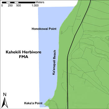
Name: Map of Kahekili Herbivore Fishery Management Area
URL Type:
Browse Graphic
Map of Kahekili Herbivore Fishery Management Area
File Resource Format: JPG
Description:

Map of Kahekili Herbivore Fishery Management Area

Data Quality

Representativeness:

Data are from haphazardly located surveys and are believed to be highly representative.

Accuracy:

Benthic cover estimates derived from analysis of photographs are dependent on image quality, which was generally good as photographs were taken with a high resolution (8-20.2 MP) digital camera from 1 m above the reef substrate in generally clear water. Image quality is almost always more than sufficient for there to be high confidence in the accuracy of identification of benthic genera and functional groups by trained analysts.

Completeness Report:

The survey sites were selected using a haphazard process based on available habitat and bathymetric habitats.

Conceptual Consistency:

Survey methods were consistent across all sites.

Quality Control Procedures Employed:

The photos are reviewed by the diver for accuracy and usability.

Data Management

Have Resources for Management of these Data Been Identified?: Yes
Approximate Percentage of Budget for these Data Devoted to Data Management: Unknown
Do these Data Comply with the Data Access Directive?: Yes
Is Access to the Data Limited Based on an Approved Waiver?: No
Approximate Delay Between Data Collection and Dissemination: Unknown
Actual or Planned Long-Term Data Archive Location: NCEI-MD
Approximate Delay Between Data Collection and Archiving: Unknown
How Will the Data Be Protected from Accidental or Malicious Modification or Deletion Prior to Receipt by the Archive?:

The images reside on a file server maintained and regularly backed up by PIFSC ITS.

Lineage

Lineage Statement:

The haphazard sampling design and benthic photoquadrat survey methodology has been employed by the NOAA Ecosystem Sciences Division (ESD) from 2008 to 2021. Benthic imagery is collected at haphazardly selected sites. These photos are color-corrected (if necessary) prior to analysis. The data management team also uses an optical validation script to rename photos and enforce several validation checks.

Sources

Williams ID, White DJ, Sparks RT, Lino KC, Zamzow JP, Kelly ELA, et al. (2016) Responses of Herbivorous Fishes and Benthos to 6 Years of Protection at the Kahekili Herbivore Fisheries Management Area, Maui. PLoS ONE 11(7): e0159100. doi:10.1371/journal.pone.0159100

CC ID: 1063210
Contact Role Type: Originator
Contact Type: Organization
Contact Name: Pacific Islands Fisheries Science Center, PIFSC
Publish Date: 2016-07-27
Citation URL: https://doi.org/10.1371/journal.pone.0159100
Citation URL Name: PLOS One
Citation URL Description:

Responses of Herbivorous Fishes and Benthos to 6 Years of Protection at the Kahekili Herbivore Fisheries Management Area, Maui

Source Contribution:

Research article of findings from the data described herein.

Process Steps

Process Step 1

CC ID: 1063213
Description:

Still photographs were taken with a high-resolution digital camera at 1-m intervals along each 30-m transect from 1 m above. 25 photoquadrat images were analyzed per site.

Process Contact: Kindinger, Tye
Email Address: tye.kindinger@noaa.gov

Process Step 2

CC ID: 1063214
Description:

To ensure consistency, images were color corrected using Adobe Lightroom if it appeared that the camera they were taken from was not properly white balanced in the field. The file naming convention for each photo/image is KA[YEAR][MONTH]_[SURVEY#]_[GenericImageName] (e.g., KA2103_123_IMG_7933.JPG).

Process Contact: Kindinger, Tye
Email Address: tye.kindinger@noaa.gov

Acquisition Information

Instruments

Instrument Unavailable Reason: Not Applicable

Platforms

Platform Unavailable Reason: Not Applicable

Child Items

Rubric scores updated every 15m

Rubric Score Type Title
Entity KahekiliSiteMetadata_DataDictionary

Related Items

Item Type Relationship Type Title
Data Set (DS) Cross Reference Fish, Benthic and Urchin Survey Data from Kahekili Herbivore Fisheries Management Area (HFMA), Maui since 2008

Benthic cover data produced as a result of the imagery.

Catalog Details

Catalog Item ID: 64552
GUID: gov.noaa.nmfs.inport:64552
Metadata Record Created By: Brooke Olenski
Metadata Record Created: 2021-04-21 19:45+0000
Metadata Record Last Modified By: SysAdmin InPortAdmin
Metadata Record Last Modified: 2023-10-17 16:12+0000
Metadata Record Published: 2022-07-07
Owner Org: PIFSC
Metadata Publication Status: Published Externally
Do Not Publish?: N
Metadata Last Review Date: 2022-07-07
Metadata Review Frequency: 1 Year
Metadata Next Review Date: 2023-07-07