Search Help Show/Hide Menu
Summary
Item Identification
Keywords
Physical Location
Data Set Info
Support Roles
Extents
Access Info
Distribution Info
URLs
Data Quality
Data Management
Lineage
Acquisition Info
Child Items
Related Items
Catalog Details

Summary

Preview graphic for Saipan Lagoon Benthic Habitat Map Data

Short Citation
National Centers for Coastal Ocean Science, 2024: NCCOS Project: Mapping Habitat Change in Saipan Lagoon, CNMI, https://www.fisheries.noaa.gov/inport/item/52924.
Full Citation Examples

DOI: doi:10.7289/V5NV9GB9
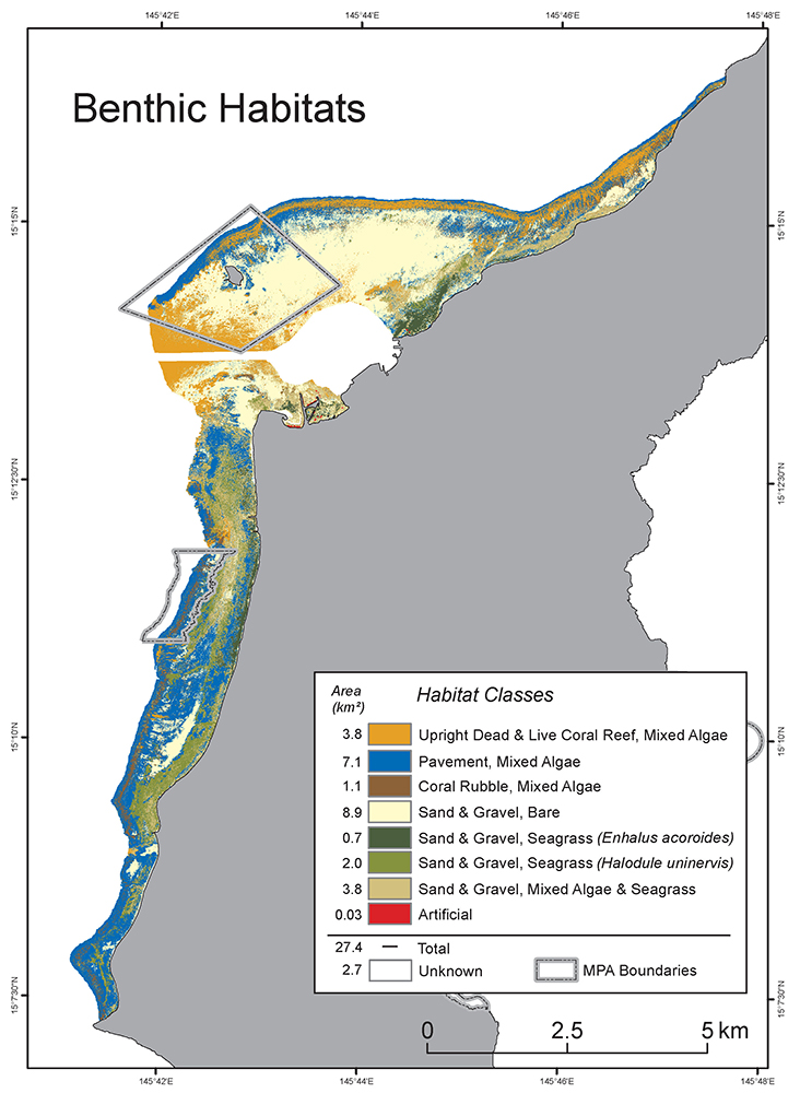
Abstract

In 2004, shallow-water benthic habitats were mapped in Saipan Lagoon, Commonwealth of the Northern Mariana Islands. Since then, habitats in the lagoon have likely changed because of coral bleaching events and recent typhoons. Local resource managers requested an updated map to help better understand these habitat changes and to help inform their monitoring and management decisions. In response, we created an updated benthic habitat map for areas shallower than 30-meters inside the lagoon.

Distribution Information

  • Kendall, M., B. Costa, S. McKagan, and L. Johnston. 2017. Benthic habitat maps of Saipan Lagoon, Commonwealth of the Northern Mariana Islands (NCEI Accession 0162517). NOAA National Centers for Environmental Information. Dataset. https://doi.org/10.7289/V5NV9GB9

  • ESRI REST Service

    CNMI's Bureau of Environmental and Coastal Quality (BECQ) and NOAA's Pacific Islands Regional Office (PIRO) partnered with NOAA's National Centers for Coastal Ocean Science (NCCOS) to develop updated habitat maps and assess habitat changes in Saipan Lagoon,CNMI. NCCOS developed these spatially resolved maps using environmental predictors, underwater videos/photos and mathematical modeling techniques. The new maps were designed to inform the Saipan Lagoon Use Management Plan (SLUMP), which is being updated in response to changes in lagoon habitats, user activities, and increases in tourism. Understanding the present spatial distribution of benthic habitats is an important part of the Territorial Government's process to evaluate zoning scenarios, minimize user conflicts, ensure public safety, and prevent environmental degradation inside the lagoon. Products from this assessment may also support coastal and ocean management efforts by other territorial and federal agencies working in Saipan. This work was funded by NOAA Coral Reef Conservation Program (CRCP Project #31100).

  • A free, fully interactive, user friendly, online platform designed to let users explore benthic habitat mapping data. Users can create fully customizable maps by clicking on a data layer in the table of contents and display aerial and acoustic imagery rasters, benthic habitat and geographic zone shapefiles, and ground validation/accuracy assessment video sites. Ground validation and accuracy assessment videos are available for viewing (streaming) and for download in standard or high resolution.

  • MP4

    Online directory containing video files.

  • CSV - Comma Separated Values (Text)

    Data index containing file-level documentation for all video including benthic habitat characteristics: FID; PROJECT; GEOGRAPHIC REGION; SITE TYPE; ASSESSMENT TYPE; SITE ID; DATE COLLECTED; TIME COLLECTED; LATITUDE; LONGITUDE; NORTHING; EASTING; DEPTH; URL LINK; CORAL REEF; PAVEMENT; RHODOLITH; SAND; HARD CORAL; SOFT CORAL; MACROALGAE; SPONGE; SEAGRASS; ARTIFICIAL; UNKNOWN; NOTES (from the field or the data managers).

Access Constraints:

None

Use Constraints:

None

Controlled Theme Keywords

BENTHIC

Contact Information

Point of Contact
Will Sautter
will.sautter@noaa.gov

Metadata Contact
NCCOS Scientific Data Coordinator
NCCOS.data@noaa.gov

Extents

Geographic Area 1

145.684723941° W, 145.794770192° E, 15.2742160669° N, 15.1209203637° S

Time Frame 1
2015-12 - 2017-03

Item Identification

Title: NCCOS Project: Mapping Habitat Change in Saipan Lagoon, CNMI
Short Name: NCCOS Project: Saipan Lagoon Mapping
Status: Completed
Creation Date: 2016
Publication Date: 2017-05-19
Abstract:

In 2004, shallow-water benthic habitats were mapped in Saipan Lagoon, Commonwealth of the Northern Mariana Islands. Since then, habitats in the lagoon have likely changed because of coral bleaching events and recent typhoons. Local resource managers requested an updated map to help better understand these habitat changes and to help inform their monitoring and management decisions. In response, we created an updated benthic habitat map for areas shallower than 30-meters inside the lagoon.

Purpose:

Shallow-water benthic habitats in Saipan Lagoon, Commonwealth of the Northern Mariana Islands (CNMI) have been stressed by recent typhoons and bleaching events. In March 2015, an El Niño event began in the equatorial Pacific, resulting in increased storm activity in the region and substantial coral bleaching. Estimates suggest that approximately 85 percent of staghorn corals in Saipan Lagoon have died due to bleaching since 2013. In August 2015, Typhoon Soudelor swept through the Pacific, directly hitting Saipan. Preliminary estimates indicate that some coral reefs were severely impacted by the storm.

The combination of these stressors and other human-caused threats has most likely changed the composition of habitats in Saipan Lagoon. Local resource managers from CNMI’s Bureau of Environmental and Coastal Quality requested that the existing habitat map - produced by the University of Guam in 2004 - be updated to better understand these and other habitat changes over the last decade. This updated map is being used to inform monitoring and management decisions in the lagoon, including updating the Saipan Lagoon Use Management Plan.

The products developed during this project provide a critical spatial framework to better understand benthic habitat changes over the last decade in Saipan Lagoon. Future projects or management actions in Saipan Lagoon will benefit greatly from the updated imagery, habitat map, and underwater photos and videos compiled during this project. These data sets will inform decisions about sampling, permitting activities, management of marine protected areas (MPAs), land-based sources of pollution, fishery regulations, climate change, and scientific research.

Supplemental Information:

Partners: CNMI Bureau of Environmental and Coastal Quality (BECQ).

Funding:

US DOC; NOAA; NOS; National Centers for Coastal Ocean Science (NCCOS), NCCOS Project #271, “Mapping Habitat Change in Saipan Lagoon, CNMI.”

US DOC; NOAA; NOS; Coral Reef Conservation Program (CRCP), CRCP Project #31100, “Mapping Habitat Change in Saipan Lagoon, CNMI.”

DOI (Digital Object Identifier): doi:10.7289/V5NV9GB9

Keywords

Theme Keywords

Thesaurus Keyword
Global Change Master Directory (GCMD) Science Keywords
EARTH SCIENCE > BIOSPHERE > ECOSYSTEMS > MARINE ECOSYSTEMS > BENTHIC
UNCONTROLLED
Global Change Master Directory (GCMD) Data Center Keywords DOC/NOAA/NESDIS/NCEI > National Centers for Environmental Information, NESDIS, NOAA, U.S. Department of Commerce
Global Change Master Directory (GCMD) Data Center Keywords DOC/NOAA/NOS/NCCOS > National Centers for Coastal Ocean Science, National Ocean Service, NOAA, U.S. Department of Commerce
NCCOS Keywords NCCOS Research Data Type > Derived Data Product
NCCOS Keywords NCCOS Research Data Type > Field Observation
NCCOS Keywords NCCOS Research Data Type > Geospatial
NCCOS Keywords NCCOS Research Data Type > Video
NCCOS Keywords NCCOS Research Priority > Marine Spatial Ecology
NCCOS Keywords NCCOS Research Topic > Ecological and Biogeographic Assessments
NCCOS Keywords NCCOS Research Topic > Habitat Mapping

Spatial Keywords

Thesaurus Keyword
Global Change Master Directory (GCMD) Location Keywords
OCEAN > PACIFIC OCEAN > WESTERN PACIFIC OCEAN > MICRONESIA > NORTHERN MARIANA ISLANDS
UNCONTROLLED
NCCOS Keywords NCCOS Research Location > Region > Pacific Ocean
NCCOS Keywords NCCOS Research Location > U.S. States and Territories > Commonwealth of the Northern Mariana Islands (CNMI)
NODC Sea Area Names Thesaurus Lighthouse Reef Trochus Sanctuary
NODC Sea Area Names Thesaurus Mañagaha Marine Conservation District
NODC Sea Area Names Thesaurus Saipan
NODC Sea Area Names Thesaurus Saipan Lagoon
NODC Sea Area Names Thesaurus Western Pacific

Physical Location

Organization: National Centers for Coastal Ocean Science
City: Silver Spring
State/Province: MD

Data Set Information

Data Set Scope Code: Data Set
Data Presentation Form: Map (digital)

Support Roles

Data Steward

CC ID: 759443
Date Effective From: 2017
Date Effective To:
Contact (Position): NCCOS Scientific Data Coordinator
Email Address: NCCOS.data@noaa.gov

Distributor

CC ID: 759444
Date Effective From: 2017
Date Effective To:
Contact (Position): NCCOS Scientific Data Coordinator
Email Address: NCCOS.data@noaa.gov

Distributor

CC ID: 759496
Date Effective From: 2017
Date Effective To:
Contact (Organization): National Centers for Environmental Information - Stennis Space Center, Mississippi (NCEI-MS)
Address: Building 1021, Suite 1003
Stennis Space Center, MS 39529
Phone: (228) 688-2936

Metadata Contact

CC ID: 759445
Date Effective From: 2017
Date Effective To:
Contact (Position): NCCOS Scientific Data Coordinator
Email Address: NCCOS.data@noaa.gov

Point of Contact

CC ID: 759446
Date Effective From: 2017
Date Effective To:
Contact (Person): Sautter, Will
Email Address: will.sautter@noaa.gov
View Historical Support Roles

Extents

Extent Group 1

Extent Group 1 / Geographic Area 1

CC ID: 759450
W° Bound: 145.684723941
E° Bound: 145.794770192
N° Bound: 15.2742160669
S° Bound: 15.1209203637

Extent Group 1 / Time Frame 1

CC ID: 759451
Time Frame Type: Range
Start: 2015-12
End: 2017-03

Access Information

Security Class: Unclassified
Data Access Procedure:

Download from website

Data Access Constraints:

None

Data Use Constraints:

None

Distribution Information

Distribution 1

CC ID: 759452
Download URL: https://doi.org/10.7289/V5NV9GB9
Distributor: National Centers for Environmental Information - Stennis Space Center, Mississippi (NCEI-MS) (2017 - Present)
File Name: Saipan Lagoon Benthic Habitat Map Data
Description:

Kendall, M., B. Costa, S. McKagan, and L. Johnston. 2017. Benthic habitat maps of Saipan Lagoon, Commonwealth of the Northern Mariana Islands (NCEI Accession 0162517). NOAA National Centers for Environmental Information. Dataset. https://doi.org/10.7289/V5NV9GB9

File Type (Deprecated): NCEI Data Archive Accession

Distribution 2

CC ID: 759455
Download URL: https://gis.ngdc.noaa.gov/arcgis/rest/services/nccos/BenthicMapping_Saipan_Dynamic/MapServer
Distributor: National Centers for Environmental Information - Stennis Space Center, Mississippi (NCEI-MS) (2017 - Present)
File Name: Saipan Lagoon MapServer Web Service
Description:

CNMI's Bureau of Environmental and Coastal Quality (BECQ) and NOAA's Pacific Islands Regional Office (PIRO) partnered with NOAA's National Centers for Coastal Ocean Science (NCCOS) to develop updated habitat maps and assess habitat changes in Saipan Lagoon,CNMI. NCCOS developed these spatially resolved maps using environmental predictors, underwater videos/photos and mathematical modeling techniques. The new maps were designed to inform the Saipan Lagoon Use Management Plan (SLUMP), which is being updated in response to changes in lagoon habitats, user activities, and increases in tourism. Understanding the present spatial distribution of benthic habitats is an important part of the Territorial Government's process to evaluate zoning scenarios, minimize user conflicts, ensure public safety, and prevent environmental degradation inside the lagoon. Products from this assessment may also support coastal and ocean management efforts by other territorial and federal agencies working in Saipan. This work was funded by NOAA Coral Reef Conservation Program (CRCP Project #31100).

File Type (Deprecated): ESRI Map Service
Distribution Format: ESRI REST Service

Distribution 3

CC ID: 759456
Download URL: https://maps.coastalscience.noaa.gov/biomapper/biomapper.html?id=Saipan
Distributor: NCCOS Scientific Data Coordinator (2017 - Present)
File Name: Saipan Lagoon BIOMapper Web Application
Description:

A free, fully interactive, user friendly, online platform designed to let users explore benthic habitat mapping data. Users can create fully customizable maps by clicking on a data layer in the table of contents and display aerial and acoustic imagery rasters, benthic habitat and geographic zone shapefiles, and ground validation/accuracy assessment video sites. Ground validation and accuracy assessment videos are available for viewing (streaming) and for download in standard or high resolution.

File Type (Deprecated): Web Application

Distribution 4

CC ID: 759453
Download URL: https://nccos-coastalscience-products-web.azurewebsites.net/biomapper_explorer/index.php?path=QW40VlZlN1g5VS9FSlBmaHRSd1BIZz09
Distributor: NCCOS Scientific Data Coordinator (2017 - Present)
File Name: Saipan Lagoon Video Explorer
Description:

Online directory containing video files.

File Type (Deprecated): MP4
Distribution Format: MP4

Distribution 5

CC ID: 759454
Download URL: https://nccos-coastalscience-products-web.azurewebsites.net/biomapper_explorer/index.php?path=RHE5YWlxN1p2bkpSb2xtd2xxRW42MjFSNFdwdGR4cFQ0d05Fdm92ektZdWdYN2p2QkZDZi80SDFMNEpYWlBaY2RaRWJZOGswbFZpUUl4R05sd0MrQnc9PQ==&uri=YmdISDNIakc0a2poU1hsN
Distributor: NCCOS Scientific Data Coordinator (2017 - Present)
File Name: Data Index for Saipan Lagoon Video
Description:

Data index containing file-level documentation for all video including benthic habitat characteristics: FID; PROJECT; GEOGRAPHIC REGION; SITE TYPE; ASSESSMENT TYPE; SITE ID; DATE COLLECTED; TIME COLLECTED; LATITUDE; LONGITUDE; NORTHING; EASTING; DEPTH; URL LINK; CORAL REEF; PAVEMENT; RHODOLITH; SAND; HARD CORAL; SOFT CORAL; MACROALGAE; SPONGE; SEAGRASS; ARTIFICIAL; UNKNOWN; NOTES (from the field or the data managers).

File Type (Deprecated): CSV
Distribution Format: CSV - Comma Separated Values (Text)

URLs

URL 1

CC ID: 759457
URL: https://coastalscience.noaa.gov/project/mapping-habitat-change-saipan-lagoon-cnmi/
Name: NCCOS Research Project Webpage: Mapping Habitat Change in Saipan Lagoon, CNMI
URL Type:
Online Resource
Description:

NCCOS Research Project Webpage: Mapping Habitat Change in Saipan Lagoon, CNMI

URL 2

CC ID: 759458
URL: https://products.coastalscience.noaa.gov/collections/benthic/default.aspx
Name: NCCOS Data Collections: Benthic Habitat Mapping
URL Type:
Online Resource
Description:

NCCOS Data Collections: Benthic Habitat Mapping

URL 3

CC ID: 759459
URL: https://www.nodc.noaa.gov/archive/arc0107/0162517/1.1/about/0162517_preview.jpg
Name: Preview graphic for Saipan Lagoon Benthic Habitat Map Data
URL Type:
Browse Graphic
Preview graphic for Saipan Lagoon Benthic Habitat Map Data
Description:

Preview graphic for Saipan Lagoon Benthic Habitat Map Data

Data Quality

Completeness Report:

Substrate and cover predictions and the composite habitat map were reviewed and accepted by local subject matter experts and resource managers in Saipan, CNMI. The performance of these predictions and the accuracy of this habitat map were also assessed using an independent dataset. Please see the following publication for more details: Kendall et al. (2017).

Quality Control Procedures Employed:

For details of data quality control methods, see Kendall et al. (2017). All users should independently analyze the dataset according to their own needs and standards to determine data usability.

Data Management

Have Resources for Management of these Data Been Identified?: No
Approximate Percentage of Budget for these Data Devoted to Data Management: Unknown
Do these Data Comply with the Data Access Directive?: Yes
Is Access to the Data Limited Based on an Approved Waiver?: No
Approximate Delay Between Data Collection and Dissemination: Two months
If Delay is Longer than Latency of Automated Processing, Indicate Under What Authority Data Access is Delayed:

Not Applicable

Actual or Planned Long-Term Data Archive Location: NCEI-MS
Approximate Delay Between Data Collection and Archiving: Two months
How Will the Data Be Protected from Accidental or Malicious Modification or Deletion Prior to Receipt by the Archive?:

NCCOS IT Policy

Lineage

Sources

Houk, P., and R. van Woesik. 2008. Dynamics of shallow-water assemblages in the Saipan Lagoon. Marine Ecology Progress Series, 356:39-50. https://doi.org/10.3354/meps07252

CC ID: 759483
Citation URL: https://doi.org/10.3354/meps07252
Citation URL Name: Houk and van Woesik, 2008
Citation URL Description:

Houk and van Woesik, 2008

Kendall, M.S., B. Costa, S. McKagan, L. Johnston, and D. Okano. 2017. Benthic habitat maps of Saipan Lagoon. NOAA Technical Memorandum NOS NCCOS 229. Silver Spring, MD. 77 pp. https://doi.org/10.7289/V5/TM-NOS-NCCOS-229

CC ID: 759481
Citation URL: https://doi.org/10.7289/V5/TM-NOS-NCCOS-229
Citation URL Name: NOAA Technical Memorandum NOS NCCOS 229
Citation URL Description:

NOAA Technical Memorandum NOS NCCOS 229

National Centers for Coastal Ocean Science. 2018. NCCOS Assessment: Underwater Video and Photographs for Ground Validation and Accuracy Assessment of Benthic Habitat Maps of Saipan Lagoon, Commonwealth of the Northern Mariana Islands, 2016-07-28 to 2016-08-09. https://www.fisheries.noaa.gov/inport/item/52923

CC ID: 759482
Citation URL: https://www.fisheries.noaa.gov/inport/item/52923
Citation URL Name: Video Metadata
Citation URL Description:

Video Metadata

Process Steps

Process Step 1

CC ID: 759497
Description:

We used multispectral imagery to produce an updated, shallow-water benthic habitat map for Saipan Lagoon. A new satellite image of the lagoon was collected in February 2016. This remote sensing data was used to develop a new habitat map. The resulting habitat map depicts the distribution of key biological and geomorphological habitats using a classification scheme comparable to Houk and van Woesik, 2008. We collected underwater photos and videos in partnership with local experts in CNMI. These photos and videos were used to improve the quality of the habitat map. A separate accuracy assessment was conducted to independently assess the thematic accuracy of the resulting habitat map. Local experts from the jurisdictional community evaluated the habitat map products before they were finalized. The final habitat map and associated products are publicly available for download and for viewing online.

Process Contact: Sautter, Will
Email Address: will.sautter@noaa.gov
Source: Kendall, M.S., B. Costa, S. McKagan, L. Johnston, and D. Okano. 2017. Benthic habitat maps of Saipan Lagoon. NOAA Technical Memorandum NOS NCCOS 229. Silver Spring, MD. 77 pp. https://doi.org/10.7289/V5/TM-NOS-NCCOS-229

Acquisition Information

Instruments

Instrument Unavailable Reason: Not Applicable

Platforms

Platform Unavailable Reason: Not Applicable

Catalog Details

Catalog Item ID: 52924
GUID: gov.noaa.nmfs.inport:52924
Metadata Record Created By: Jessica Morgan
Metadata Record Created: 2018-06-25 15:42+0000
Metadata Record Last Modified By: SysAdmin InPortAdmin
Metadata Record Last Modified: 2023-10-17 16:12+0000
Metadata Record Published: 2021-04-07
Owner Org: NCCOS
Metadata Publication Status: Published Externally
Do Not Publish?: N
Metadata Last Review Date: 2021-04-07
Metadata Review Frequency: 1 Year
Metadata Next Review Date: 2022-04-07