National Coral Reef Monitoring Program: Assessment of coral reef benthic communities in the U.S. Virgin Islands from 2017-06-12 to 2017-08-04 (NCEI Accession 0176081)
Data Set (DS) | Southeast Fisheries Science Center (SEFSC)GUID: gov.noaa.nmfs.inport:71134 | Updated: May 15, 2025 | Published / External
Summary
Short Citation
Southeast Fisheries Science Center, 2025: National Coral Reef Monitoring Program: Assessment of coral reef benthic communities in the U.S. Virgin Islands from 2017-06-12 to 2017-08-04 (NCEI Accession 0176081), https://www.fisheries.noaa.gov/inport/item/71134.
Full Citation Examples
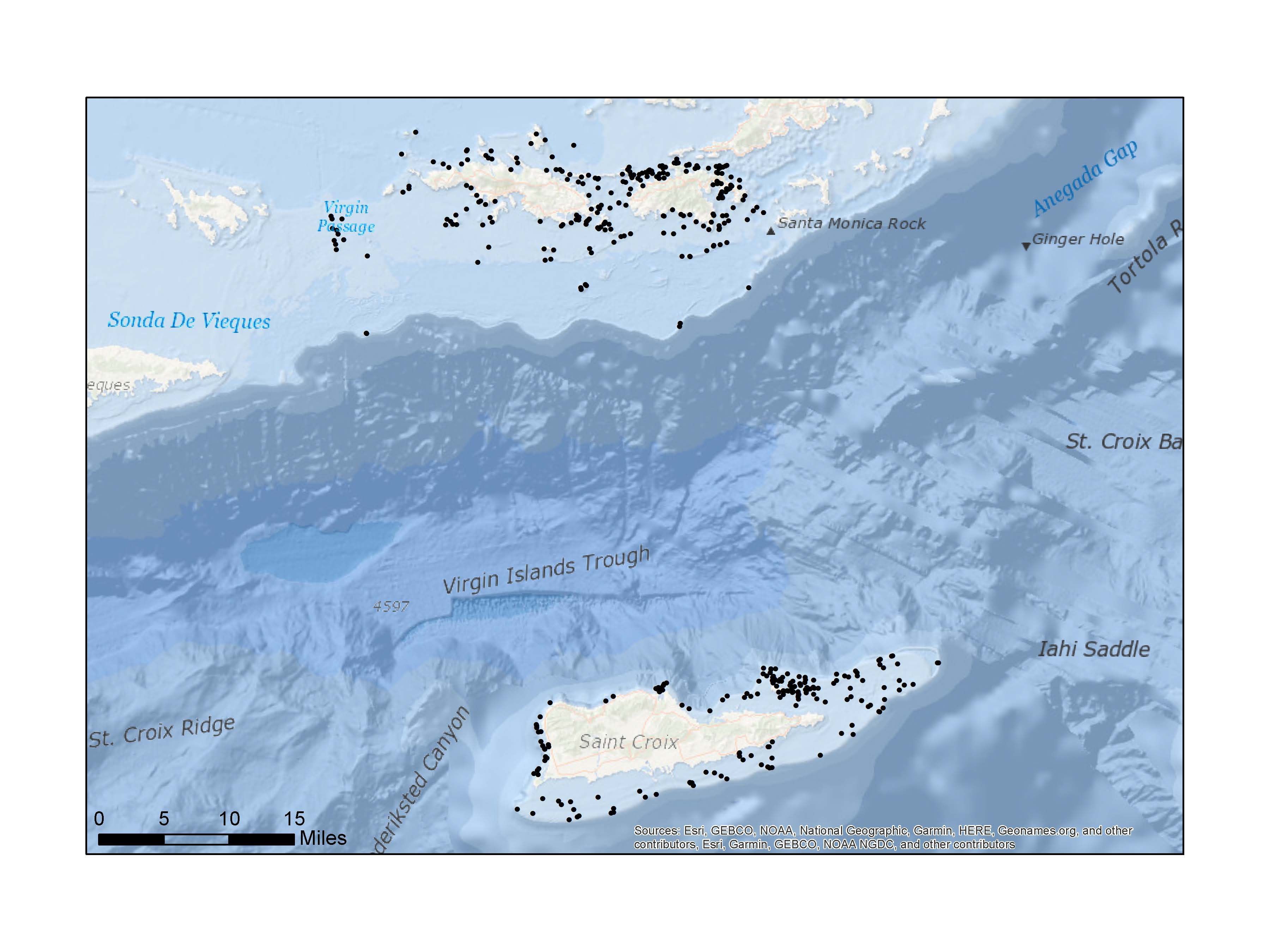
The National Coral Reef Monitoring Program (NCRMP) assessed coral reef communities in St. Croix, St. Thomas, and St. John, U.S. Virgin Islands (USVI) using two benthic surveys: the Benthic Assessment (BA) and the Coral Demographic method. Benthic Assessment provides benthic cover estimates for ecologically important cover types/groups (e.g., macroalgae, turf algae, crustose coralline algae, corals, sponges, sand/sediment, etc.) using a 1-stage stratified random survey design in hardbottom and coral reef habitats less than 30m in depth. The goals of these surveys are to provide: (1) a quantification of percent cover of biotic and abiotic benthic components using a line point-intercept (LPI) method; (2) information on topographic complexity substratum rugosity) of the survey locations (3) quantitative information on local commercially and ecologically-important macroinvertebrates (Caribbean spiny lobster [Panulirus argus], queen conch [Lobatus gigas], long-spined sea urchin [Diadema antillarum]); and (4) presence-absence information for ESA-listed Threatened corals. The goal of the coral demographic surveys is to collect and report information on species composition, density, size, abundance, and specific parameters of condition (% live vs. dead, bleaching, disease) of non-juvenile scleractinian corals (>4 cm maximum diameter), and of overall species diversity (all corals) using 10m x 1m belt transects in a stratified random sampling design in hardbottom and coral reef habitats less than 30m in depth. Both Benthic Assessment and Coral Demographic surveys are concurrent. Three datasets are provided under the Benthic Assessment and coral demographic protocols, and are distributed as one compiled package: (1) analysis ready benthic cover dataset, (2) analysis ready invertebrates/ESA dataset, and (3) analysis ready coral demographic dataset. The methodologies used for this survey can be found in the Benthic Assessment and Coral Demographic protocols. All datasets contain data fields on general station information (e.g., survey strata, depth, rugosity). Each of these data tables contain additional survey-specific data fields. For complete information and descriptions of attributes and data fields for all data tables, refer to the data dictionaries
PurposeThe National Coral Reef Monitoring Program (NCRMP) details a long-term approach to provide an ecosystem perspective via monitoring climate, fish, benthic, and socioeconomic variables in a consistent and integrated manner. The NCRMP is intended to coordinate various Coral Reef Conservation Coral Reef Program (CRCP) biological, physical, and human dimensions activities into a cohesive NOAA-wide effort. Through the implementation of the NCRMP, NOAA will be able to clearly and concisely communicate results of national-scale monitoring to national, state, and territorial policy makers, resource managers, and the public on a periodic basis. NCRMP is a framework for conducting sustained observations of biological, climate, and socioeconomic indicators at 10 priority coral reefs across the U.S. and its territories. This integrated approach will consolidate monitoring of coral reefs under a uniform method in the Pacific, Atlantic, Caribbean, and the Gulf of Mexico for the first time. NCRMP is funded by the NOAA Coral Reef Conservation Program (CRCP) and supported by NOAA National Centers for Coastal Ocean Science (NCCOS) and many other partners. NCCOS is co-leading biological monitoring missions with NOAA's Southeast Fisheries Science Center (SEFSC) to gather data on fish populations and coral reef communities in the U.S. Caribbean, Florida, and the Gulf of Mexico. Each year, our scientists work closely with CRCP and local partners to collect biological data from thousands of strategically selected sites. We then use innovative analysis techniques to develop products that give fellow scientists, managers, decision makers and the public a better understanding of a region's resources and how they are changing over time. The biological component of NCRMP provides a biennial ecological characterization at a broad spatial scale of general reef condition for reef fishes, corals and benthic habitat (i.e., fish species composition/density/size, benthic cover, and coral density/size/condition). Data collection occurs at stratified random sites where the sampling domain for each region is partitioned by habitat type and depth, sub-regional location (e.g., along-shelf position) and management zone. Data provided in this dataset are from St. Croix, St. Thomas, and St. John, and surrounding Sail Rock and mid-shelf reef region. Lead agencies involved include the National Oceanic and Atmospheric Administration's (NOAA) National Centers for Coastal Ocean Science (NCCOS), NOAA Southeast Fisheries Science Center (SEFSC) and the National Park Service (NPS).
Distribution Information
-
~ (91.776 MB)
Download Page NCEI Accession 0176081
Use liability: NOAA and NCEI cannot provide any warranty as to the accuracy, reliability, or completeness of furnished data. Users assume responsibility to determine the usability of these data. The user is responsible for the results of any application of this data for other than its intended purpose.
Use liability: NOAA and NCEI cannot provide any warranty as to the accuracy, reliability, or completeness of furnished data. Users assume responsibility to determine the usability of these data. The user is responsible for the results of any application of this data for other than its intended purpose. Use liability: NOAA and NCEI cannot provide any warranty as to the accuracy, reliability, or completeness of furnished data. Users assume responsibility to determine the usability of these data. The user is responsible for the results of any application of this data for other than its intended purpose.
Controlled Theme Keywords
BENTHIC, BIOLOGICAL CLASSIFICATION, CORAL BLEACHING, CORAL REEF, CORAL REEFS, DOC/NOAA/NESDIS/NCEI, DOC/NOAA/NMFS/SEFSC, DOC/NOAA/NOS/NCCOS, FISH
URLs
-
National Coral Reef Monitoring Program: Assessment of coral reef benthic communities in the U.S. Virgin Islands from 2017-06-12 to 2017-08-04 (NCEI Accession 0176081)
Child Items
URLs
URL 1
| URL: | https://www.ncei.noaa.gov/archive/accession/0176081/2.2/data/0-data/NCRMP_USVI2017_Benthic_ArchiveDataPackage/NCRMP_USVI2017_Benthic_ArchiveDataPackage/NCRMP_USVI2017_Benthic_BrowseGraphic.jpg |
|---|---|
| Name: | Browse Graphics For Data Set |
| URL Type: |
Browse Graphic
|
URL 2
| URL: | https://www.ncei.noaa.gov/archive/accession/0176081 |
|---|---|
| Name: | Landing Page NCEI Accession 0176081 |
| URL Type: |
Online Resource
|
| Description: |
National Coral Reef Monitoring Program: Assessment of coral reef benthic communities in the U.S. Virgin Islands from 2017-06-12 to 2017-08-04 (NCEI Accession 0176081) |
URL 3
| URL: | https://www.ncei.noaa.gov/archive/accession/0176081/2.2/data/0-data/NCRMP_USVI2017_Benthic_ArchiveDataPackage/NCRMP_USVI2017_Benthic_ArchiveDataPackage/Documentation/NCRMP_USVI2017_Benthic_PreviewGraphic_STTSTJ.jpg |
|---|---|
| Name: | Browse Graphic around St Thomas and St John |
| URL Type: |
Browse Graphic

|
URL 4
| URL: | https://www.ncei.noaa.gov/archive/accession/0176081/2.2/data/0-data/NCRMP_USVI2017_Benthic_ArchiveDataPackage/NCRMP_USVI2017_Benthic_ArchiveDataPackage/Documentation/NCRMP_USVI2017_Benthic_PreviewGraphic_STX.jpg |
|---|---|
| Name: | Browse Graphic Around St Croix |
| URL Type: |
Browse Graphic

|
Child Items
Rubric scores updated every 15m