Recovery of Queen Conch in the U. S. Virgin Islands
Data Set (DS) | Southeast Fisheries Science Center (SEFSC)GUID: gov.noaa.nmfs.inport:24265 | Updated: May 15, 2025 | Published / External
Summary
Short Citation
Southeast Fisheries Science Center, 2025: Recovery of Queen Conch in the U. S. Virgin Islands, https://www.fisheries.noaa.gov/inport/item/24265.
Full Citation Examples
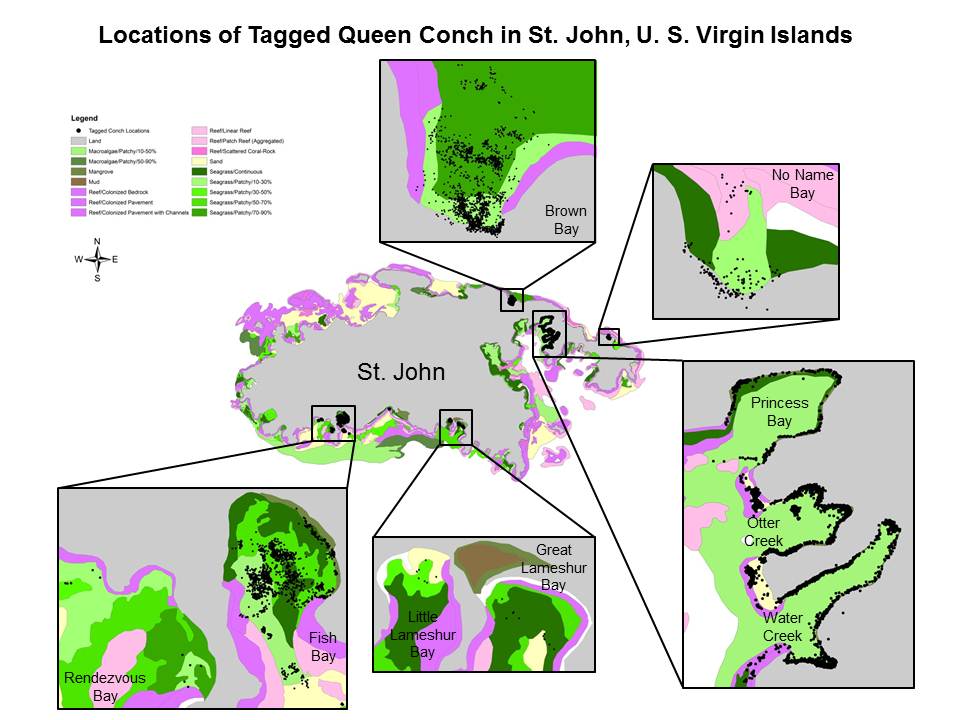
The queen conch is an important cultural component and an extremely valuable coral reef fishery resource throughout the Caribbean, historically second only to the spiny lobster. Comparisons of past studies with current densities from these areas continue to show that queen conch populations are depleted although we may be seeing small signs of increase. This data set investigates the population status of queen conch around St. John, U.S. Virgin Islands, through mark and recapture, habitat availability and utilization, acoustic tracking, and seasonal migration studies to provide needed information for improved management.
PurposeThe intent of this project is to investigate possible causes for the lack of recovery of queen conch, particularly populations of juvenile conch around St. John.
Distribution Information
-
Contains all child items of the dataset zipped into one file.
-
JPEG, 86K
locations_of_tagged_queen_conch.jpg
The National Marine Fisheries Service (NMFS) does not approve, recommend, or endorse any proprietary product or proprietary material contained in this data set. The NMFS Galveston Laboratory Fishery Ecology Branch compiled these data sets in order to develop a scientific basis for refining essential fish habitat designations for future amendments to fishery management plans. NMFS is not responsible for any uses of these data sets beyond those for which they were intended, and NMFS makes no claims regarding the accuracy of any data provided by agencies or individuals outside NMFS.
The National Marine Fisheries Service (NMFS) does not approve, recommend, or endorse any proprietary product or proprietary material contained in this data set. The NMFS Galveston Laboratory Fishery Ecology Branch compiled these data sets in order to develop a scientific basis for refining essential fish habitat designations for future amendments to fishery management plans. NMFS is not responsible for any uses of these data sets beyond those for which they were intended, and NMFS makes no claims regarding the accuracy of any data provided by agencies or individuals outside NMFS.
Controlled Theme Keywords
biota, environment, oceans
URLs
-
2007 Stock Assessment Report on Caribbean Queen Conch
Child Items
URLs
URL 1
| URL: | https://data.nodc.noaa.gov/coris/data/NOAA/nmfs/1873/locations_of_tagged_queen_conch.jpg |
|---|---|
| Name: | Queen Conch Tag Locations |
| URL Type: |
Browse Graphic
|
| File Resource Format: | jpeg |
| Description: |
All Tag Locations All Bays - Information from mark and recapture and habitat studies. |
URL 2
| URL: | http://sedarweb.org/docs/sar/S14SAR3%20Queen%20Conch%20Report.pdf |
|---|---|
| Name: | Sedar 14 Report on Caribbean Queen Conch |
| URL Type: |
Online Resource
|
| Description: |
2007 Stock Assessment Report on Caribbean Queen Conch |
Child Items
Rubric scores updated every 15m