National Coral Reef Monitoring Program: Assessment of fish communities in the Florida Reef Tract from 2014-05-01 to 2014-10-01 (NCEI Accession 0156445)
Data Set (DS) | Southeast Fisheries Science Center (SEFSC)GUID: gov.noaa.nmfs.inport:35417 | Updated: April 1, 2025 | Published / External
Summary
Short Citation
Southeast Fisheries Science Center, 2025: National Coral Reef Monitoring Program: Assessment of fish communities in the Florida Reef Tract from 2014-05-01 to 2014-10-01 (NCEI Accession 0156445), https://www.fisheries.noaa.gov/inport/item/35417.
Full Citation Examples
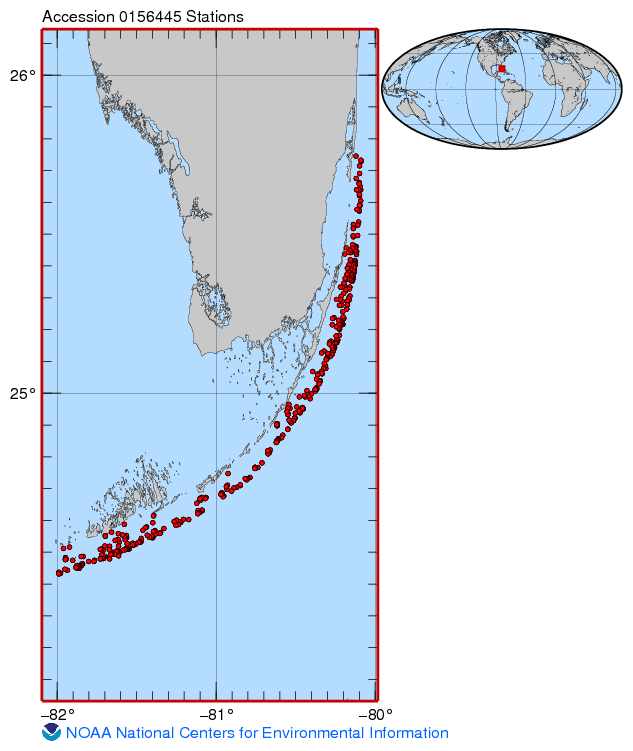
Divers conducted reef visual census (RVC) fish surveys and habitat assessments at 433 sites in the Florida Keys, 436 sites in the Dry Tortugas and 320 sites in the Southeast Florida Coral Reef Initiative (SEFCRI) region. NOAA Southeast Fisheries Science Center (SEFSC) divers collaborated with the University of Miami and the Rosenstiel School of Marine & Atmospheric Science (RSMAS), Florida Keys National Marine Sanctuary (FKNMS), Florida Fish and Wildlife Department/Fish and Wildlife Research Institute (FWRI), State of Florida, Nova Southeastern University, and the National Park Service (South Florida and Caribbean Network). In total, it took 4718 dives to complete the 2014 mission to monitor reef fish community composition, habitat composition, and abundance and size structure for more than 300 reef fish species on Florida's coral reef tract.
PurposeThe National Coral Reef Monitoring Program (NCRMP) details a long-term approach to provide an ecosystem perspective via monitoring climate, fish, benthic, and socioeconomic variables in a consistent and integrated manner. The NCRMP is intended to coordinate various Coral Reef Conservation Coral Reef Program (CRCP) biological, physical, and human dimensions activities into a cohesive NOAA-wide effort. Through the implementation of the NCRMP, NOAA will be able to clearly and concisely communicate results of national-scale monitoring to national, state, and territorial policy makers, resource managers, and the public on a periodic basis.
Distribution Information
-
115.736 MB
NCEI Archive Package - FISH - CORAL REEF collected from Small Boats in Florida Keys Reef Tract from 2014-05-01 to 2014-10-01 (NCEI Accession 0156445)
None
Please reference NOAA/NMFS/SEFSC when utilizing these data in a report or peer reviewed publication.
Cite as:
NOAA Southeast Fisheries Science Center (SEFSC). 2016. National Coral Reef Monitoring Program: FISH - CORAL REEF collected from Small Boats in Florida Keys Reef Tract from 2014-05-01 to 2014-10-01 (NCEI Accession 0156445)
Additionally, knowledge of how this dataset has been of use and which organizations are utilizing it is of great benefit for ensuring this information continues to meet the needs of the management and research communities. Therefore, it is requested but not mandatory, that any user of this data supply this information to the Project Co- Invstigator (Atlantic/Caribbean): Matthew Johnson (matthew.johnson@noaa.gov)
Controlled Theme Keywords
BENTHIC, BIOLOGICAL CLASSIFICATION, CORAL REEFS, DOC/NOAA/NESDIS/NCEI, DOC/NOAA/NMFS/SEFSC, DOC/NOAA/NOS/NMS, DOI/NPS, FISH, U-MIAMI/RSMAS
URLs
-
ERDDAP > tabledap > Data Access Form
Dataset Title: CRCP_Reef_Fish_Surveys_Florida RSS
Institution: Coral Reef Conservation Program (Dataset ID: CRCP_Reef_Fish_Surveys_Florida)
-
Title : A stationary visual census technique for quantitatively assessing community structure of coral reef fishes
Personal Author(s) : Bohnsack, James A. (James Anthony), 1947-;Bannerot, Scott P., 1959-;
Corporate Authors(s) : United States, National Marine Fisheries Service;United States, National Oceanic and Atmospheric Administration,;Coral Reef Conservation Program (U.S.);
Published Date : 1986
Series : NOAA technical report NMFS ; 41
URL : https://repository.library.noaa.gov/view/noaa/1005
Child Items
URLs
URL 1
| URL: | https://www.ncei.noaa.gov/erddap/tabledap/CRCP_Reef_Fish_Surveys_Florida.html |
|---|---|
| Name: | Coral Reef Conservation Program ERDDAP Page |
| URL Type: |
Online Resource
|
| Description: |
ERDDAP > tabledap > Data Access Form Dataset Title: CRCP_Reef_Fish_Surveys_Florida RSS Institution: Coral Reef Conservation Program (Dataset ID: CRCP_Reef_Fish_Surveys_Florida) |
URL 2
| URL: | https://repository.library.noaa.gov/view/noaa/1005 |
|---|---|
| Name: | NOAA Technical Report NMFS 41 July 1986 |
| URL Type: |
Online Resource
|
| File Resource Format: | |
| Description: |
Title : A stationary visual census technique for quantitatively assessing community structure of coral reef fishes Personal Author(s) : Bohnsack, James A. (James Anthony), 1947-;Bannerot, Scott P., 1959-; Corporate Authors(s) : United States, National Marine Fisheries Service;United States, National Oceanic and Atmospheric Administration,;Coral Reef Conservation Program (U.S.); Published Date : 1986 Series : NOAA technical report NMFS ; 41 URL : https://repository.library.noaa.gov/view/noaa/1005 |
URL 3
| URL: | https://www.ncei.noaa.gov/archive/accession/0156445/3.3/about/0156445_map.jpg |
|---|---|
| Name: | Sampling Map For Accession 0156445 |
| URL Type: |
Browse Graphic
|
URL 4
| URL: | https://www.ncei.noaa.gov/archive/accession/0156445 |
|---|---|
| Name: | Landing Page NCEI Accession 0156445 |
| URL Type: |
Online Resource
|
| File Resource Format: | html |
Child Items
Rubric scores updated every 15m