



NOAA NCCOS Assessment: Agency priorities for mapping coral reef ecosystems in Hawaii, 2022-07-08 to 2022-08-01
Data Set (DS) | National Centers for Coastal Ocean Science (NCCOS)GUID: gov.noaa.nmfs.inport:69455 | Updated: June 6, 2026 | Published / External
Keywords
Theme Keywords
| Thesaurus | Keyword |
|---|---|
| Global Change Master Directory (GCMD) Science Keywords |
EARTH SCIENCE > BIOSPHERE > ECOSYSTEMS > MARINE ECOSYSTEMS > COASTAL
|
| Global Change Master Directory (GCMD) Science Keywords |
EARTH SCIENCE > HUMAN DIMENSIONS > ENVIRONMENTAL GOVERNANCE/MANAGEMENT > ENVIRONMENTAL ASSESSMENTS
|
| UNCONTROLLED | |
| CoRIS Discovery Thesaurus | Documents > Observational Report |
| CoRIS Discovery Thesaurus | Geographic Information > Marine Managed Areas |
| CoRIS Discovery Thesaurus | Geographic Information > Socioeconomic |
| CoRIS Discovery Thesaurus | Numeric Data Sets > Bathymetry |
| CoRIS Theme Thesaurus | EARTH SCIENCE > Biosphere > Zoology > Corals > Reef Monitoring and Assessment > Mapping |
| NCCOS Keywords | NCCOS Research Data Type > Derived Data Product |
| NCCOS Keywords | NCCOS Research Data Type > Geospatial |
| NCCOS Keywords | NCCOS Research Priority > Marine Spatial Ecology |
| NCCOS Keywords | NCCOS Research Topic > Ecological and Biogeographic Assessments |
| NCCOS Keywords | NCCOS Research Topic > Habitat Mapping |
Spatial Keywords
| Thesaurus | Keyword |
|---|---|
| Global Change Master Directory (GCMD) Location Keywords |
CONTINENT > NORTH AMERICA > UNITED STATES OF AMERICA > HAWAII
|
| Global Change Master Directory (GCMD) Location Keywords |
OCEAN > PACIFIC OCEAN > CENTRAL PACIFIC OCEAN > HAWAIIAN ISLANDS
|
| UNCONTROLLED | |
| CoRIS Place Country/Territory Keywords | COUNTRY/TERRITORY > United States of America > Hawaiian Islands |
| CoRIS Place Ocean/Seas Keywords | OCEAN BASIN > Pacific Ocean > Central Pacific Ocean > Hawaiian Islands |
| NCCOS Keywords | NCCOS Research Location > Region > Pacific Ocean |
| NCCOS Keywords | NCCOS Research Location > U.S. States and Territories > Hawaii |
| Sea Areas, Water Bodies, Marine Protected Areas | Hawaii |
| Sea Areas, Water Bodies, Marine Protected Areas | Pacific Ocean |
Physical Location
| Organization: | National Centers for Coastal Ocean Science |
|---|---|
| City: | Silver Spring |
| State/Province: | MD |
Data Set Information
| Data Set Scope Code: | Data Set |
|---|---|
| Data Presentation Form: | Map (digital) |
Support Roles
Data Steward
| Date Effective From: | 2023 |
|---|---|
| Date Effective To: | |
| Contact (Position): | NCCOS Scientific Data Coordinator |
| Address: | |
| Email Address: | NCCOS.data@noaa.gov |
Distributor
| Date Effective From: | 2023 |
|---|---|
| Date Effective To: | |
| Contact (Organization): | NOAA GeoPlatform |
| Address: | |
| Email Address: | gis.community@noaa.gov |
| URL: | homepage |
Distributor
| Date Effective From: | 2023 |
|---|---|
| Date Effective To: | |
| Contact (Organization): | Zenodo |
| Address: | |
| URL: | Zenodo Homepage |
Metadata Contact
| Date Effective From: | 2023 |
|---|---|
| Date Effective To: | |
| Contact (Position): | NCCOS Scientific Data Coordinator |
| Address: | |
| Email Address: | NCCOS.data@noaa.gov |
Point of Contact
| Date Effective From: | 2023 |
|---|---|
| Date Effective To: | |
| Contact (Person): | Kraus, Jennifer |
| Address: | |
| Email Address: | jennifer.kraus@noaa.gov |
| Contact Instructions: |
Point of Contact LTJG Jennifer Kraus, Jennifer.kraus@noaa.gov, US DOC; NOAA; NOS; National Centers for Coastal Ocean Science (NCCOS) NCCOS Data Manager, nccos.data@noaa.gov, US DOC; NOAA; NOS; National Centers for Coastal Ocean Science (NCCOS) |
Principal Investigator
| Date Effective From: | 2023 |
|---|---|
| Date Effective To: | |
| Contact (Person): | Kraus, Jennifer |
| Address: | |
| Email Address: | jennifer.kraus@noaa.gov |
| Contact Instructions: |
Principal Investigator: LTJG Jennifer Kraus, Jennifer.kraus@noaa.gov, US DOC; NOAA; NOS; National Centers for Coastal Ocean Science (NCCOS) Additional Principal Investigator: Tim Battista, Tim.battista@noaa.gov, US DOC; NOAA; NOS; National Centers for Coastal Ocean Science (NCCOS) |
Publisher
| Date Effective From: | 2023-02-07 |
|---|---|
| Date Effective To: | |
| Contact (Position): | NCCOS Scientific Data Coordinator |
| Address: | |
| Email Address: | NCCOS.data@noaa.gov |
Extents
Extent Group 1
Extent Group 1 / Geographic Area 1
| W° Bound: | -160.271 | |
|---|---|---|
| E° Bound: | -154.798 | |
| N° Bound: | 22.266 | |
| S° Bound: | 18.89 |
Extent Group 1 / Time Frame 1
| Time Frame Type: | Range |
|---|---|
| Start: | 2022-07-08 |
| End: | 2022-08-01 |
Spatial Information
Reference Systems
Reference System 1
Coordinate Reference System |
|||||||||||||||||||||||||||||||||||||||||
|
|||||||||||||||||||||||||||||||||||||||||
Access Information
| Security Class: | Unclassified |
|---|---|
| Data Access Procedure: |
Download from website |
| Data Access Constraints: |
None |
| Data Use Constraints: |
None |
Distribution Information
Distribution 1
| Download URL: | https://doi.org/10.5281/zenodo.7615965 |
|---|---|
| Distributor: | Zenodo (2023 - Present) |
| File Name: | NCCOS_CRCP_Hawaii_ArchiveDataPackage.zip |
| Description: |
Kraus, Jennifer; Buckel, Christine; Williams, Bethany; Urqhart, Karina; Dorfman, Dan; Hile, Sarah; Pagan, Francisco; Towle, Erica. NOAA NCCOS Assessment: Agency priorities for mapping coral reef ecosystems in Hawaii, 2022-07-08 to 2022-08-01. 2023. Zenodo. https://doi.org/10.5281/zenodo.7615964 |
| File Type (Deprecated): | Zenodo Data Archive Accession |
| File Size: | 68 KB total; 4 files |
| Compression: | Zip |
Distribution 2
| Download URL: | https://us-shallow-coral-reef-mapping-priorities-noaa.hub.arcgis.com/ |
|---|---|
| Distributor: | NOAA GeoPlatform (2023 - Present) |
| File Name: | US Shallow Coral Reef Mapping Priorities |
| Description: |
US Shallow Coral Reef Mapping Priorities Data Viewer |
| File Type (Deprecated): | NOAA GeoPlatform Web Application |
Archive Information
https://doi.org/10.5281/zenodo.7615965
| Location: | Zenodo |
|---|---|
| File Identifier: | https://doi.org/10.5281/zenodo.7615965 |
| File Name: | NOAA NCCOS Assessment: Agency priorities for mapping coral reef ecosystems in Hawaii, 2022-07-08 to 2022-08-01 |
| URL: | https://doi.org/10.5281/zenodo.7615965 |
| Description: |
Kraus, J., Buckel, C., Williams, B., Urqhart, K., Dorfman, D., Hile, S., Pagan, F., & Towle, E. (2023). NOAA NCCOS Assessment: Agency priorities for mapping coral reef ecosystems in Hawaii, 2022-07-08 to 2022-08-01 [Data set]. Zenodo. https://doi.org/10.5281/zenodo.7615965 |
| DOI: | https://doi.org/10.5281/zenodo.7615965 |
| Archive Date: | 2023-02-07 |
URLs
URL 1
| URL: | https://coastalscience.noaa.gov/project/defining-future-seafloor-mapping-priorities-to-inform-shallow-coral-reef-management/ |
|---|---|
| Name: | NCCOS Project Webpage: Defining Future Seafloor Mapping Priorities to Inform Shallow Coral Reef Management |
| URL Type: |
Online Resource
|
| Description: |
NCCOS Project Webpage: Defining Future Seafloor Mapping Priorities to Inform Shallow Coral Reef Management |
URL 2
| URL: | https://doi.org/10.5281/zenodo.7615965 |
|---|---|
| Name: | NOAA NCCOS Assessment: Agency priorities for mapping coral reef ecosystems in Hawaii, 2022-07-08 to 2022-08-01 |
| URL Type: |
Online Resource
|
| File Resource Format: | Shapefile |
| Description: |
Kraus, J., Buckel, C., Williams, B., Urqhart, K., Dorfman, D., Hile, S., Pagan, F., & Towle, E. (2023). NOAA NCCOS Assessment: Agency priorities for mapping coral reef ecosystems in Hawaii, 2022-07-08 to 2022-08-01 [Data set]. Zenodo. https://doi.org/10.5281/zenodo.7615965 |
URL 3
| URL: | https://cdn.coastalscience.noaa.gov/csmedia/2020/12/Hawaii-map.png |
|---|---|
| Name: | Mapping Priorities: Hawaii |
| URL Type: |
Browse Graphic
|
| Description: |
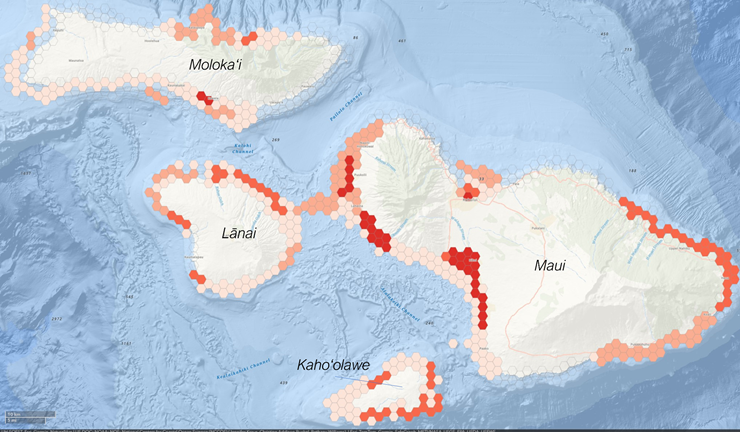
Example of the online tool used to identify seafloor mapping priorities in Hawaii. Each cell can be selected and populated with virtual coins based on the participants data needs. The tool also allows the participants to input a justification for why those cells were selected, as well as specific data product needs. Credit: NOAA NCCOS. |
Activity Log
Activity Log 1
| Activity Date/Time: | 2026-06-06 |
|---|---|
| Activity Type: | Metadata Review |
| Responsible Party: | Amber Batts |
| Description: |
Reviewed/Updated Metadata, Edited URLs |
Technical Environment
| Description: |
Total File Size: 68 KB total, 4 files in 1 folder (zipped), (68 KB zipped) Data Files: CRCP_GapAnalysis_Priorities_HI.SHP Documentation Files: NCCOS-CRCP-Prioritization_HI_ArchiveSubmission.PDF Data File Format(s): Shapefile .SHP (and ancillary files .DBF, .PRJ, .SHX) Data File Compression: zip Data File Resolution: 2.6 km2 GIS Projection: WGS 1984 (WKID 4326) |
|---|
Data Quality
| Completeness Report: |
For details of data completeness, see Lineage Sources. |
|---|---|
| Quality Control Procedures Employed: |
For details of data quality control methods, see Lineage Sources. All users should independently analyze the datasets according to their own needs and standards to determine data usability. |
Data Management
| Have Resources for Management of these Data Been Identified?: | No |
|---|---|
| Approximate Percentage of Budget for these Data Devoted to Data Management: | Unknown |
| Do these Data Comply with the Data Access Directive?: | Yes |
| Is Access to the Data Limited Based on an Approved Waiver?: | No |
| Approximate Delay Between Data Collection and Dissemination: | Three months |
| Actual or Planned Long-Term Data Archive Location: | Other |
| If World Data Center or Other, Specify: | Zenodo |
| Approximate Delay Between Data Collection and Archiving: | Six months |
| How Will the Data Be Protected from Accidental or Malicious Modification or Deletion Prior to Receipt by the Archive?: |
NCCOS IT Policy |
Lineage
Sources
Agency Priorities for Mapping Coral Reef Ecosystems in the Main Hawaiian Islands
| Contact Role Type: | Publisher |
|---|---|
| Contact Type: | Person |
| Contact Name: | LTJG Jennifer Kraus |
| Citation URL: | https://doi.org/10.25923/csw1-xw45 |
| Citation URL Name: | Publication - NOAA Technical Memorandum NOS NCCOS 311 |
| Citation URL Description: |
Kraus, J., C.A. Buckel, B. Williams, K. Urqhart, D. Dorfman, F. Pagan, E.K. Towle, and S.D. Hile. 2022. Agency Priorities for Mapping Coral Reef Ecosystems in Hawaii. NOAA Technical Memorandum NOS NCCOS 311. Silver Spring, MD. https://doi.org/10.25923/csw1-xw45 |
| Source Contribution: |
Associated Manuscript |
Buja, K., and Christensen, J. 2019. Spatial Prioritization Widget: A Tool to Identify Mapping Priorities. Available Online: https://coastalscience.noaa.gov/project/spatial-prioritization-widget/ (Accessed 26 June, 2019).
| Contact Role Type: | Publisher |
|---|---|
| Contact Type: | Person |
| Contact Name: | Ken Buja |
| Citation URL: | https://coastalscience.noaa.gov/project/spatial-prioritization-widget/ |
| Citation URL Name: | Webpage |
| Citation URL Description: |
Spatial Prioritization Widget: A Tool to Identify Mapping Priorities |
Process Steps
Process Step 1
| Description: |
An advisory group was established which included individuals from NOAA CRCP and NOAA Fisheries. This advisory team customized the prioritization process specifically to meet the needs of CRCP and local coral reef manager priorities. In the online prioritization tool, the study area was divided into 1786 hexagonal grid cells 2.6 km2 in size. Existing relevant spatial datasets (e.g., bathymetry, protected areas, etc.) were provided as a digital atlas to help participants understand information and data gaps within the project area and to identify locations they wanted to prioritize for future data collections. Each participant was provided with 540 virtual coins to place into grid cells to denote their mapping needs. They were instructed to place more coins in grid cells that were higher priority. A maximum of 54 coins could be placed into an individual grid cell by each respondent. Participants also selected from a drop-down list of predefined management uses from the following list: endangered species management (e.g.,), habitat restoration, monitoring, coastal vulnerability planning, watershed management, fisheries management, consultations and permitting, emergency response, and spatial protection and management. Respondents also selected what map product requirements were needed in priority cells by selecting a minimum of one, to a maximum of two choices from the following list: delineations of large topographic features, delineations of hard vs. soft bottom, models of habitat suitability for key taxa or communities, delineations of substrate type (e.g. sand, mud, coral, rock), models of presence/absence or density of corals, identification of coral species and their local environments, documentation of individual specimen condition. Coin values were summarized and mapped to identify high priority areas, reasons for those priorities, and information needs. This ESRI shapefile contains the 2.6 km2 grid cells used in this prioritization and their associated coin values overall, as well as by management use and map product requirement. Other summary values include the number of participants, number of participating groups, number of management uses, and number of map product requirements. Additionally, coins for microscale (identification of coral species and their local environments and documentation of individual specimen condition), mesoscale (delineations of substrate type, models of presence/absence/density of corals), and regional (delineations of topographic features, delineations of hard vs. soft bottom, models of habitat suitability) requirements were summarized. Also included is a ranking of each grid cell based on the total number of coins, management uses, and participating groups allocating coins in the respective cell. For a complete description of the process and analysis see: Kraus et al. 2023, in prep. |
|---|---|
| Process Contact: | Kraus, Jennifer |
| Email Address: | jennifer.kraus@noaa.gov |
| Source: | Agency Priorities for Mapping Coral Reef Ecosystems in the Main Hawaiian Islands |
Acquisition Information
Instruments
| Instrument Unavailable Reason: | Not Applicable |
|---|
Platforms
| Platform Unavailable Reason: | Not Applicable |
|---|
Catalog Details
| Catalog Item ID: | 69455 |
|---|---|
| GUID: | gov.noaa.nmfs.inport:69455 |
| Metadata Record Created By: | Lauren Jackson |
| Metadata Record Created: | 2023-03-21 19:24+0000 |
| Metadata Record Last Modified By: | Amber Batts |
| Metadata Record Last Modified: | 2026-06-06 18:20+0000 |
| Metadata Record Published: | 2023-03-22 |
| Owner Org: | NCCOS |
| Metadata Publication Status: | Published Externally |
| Do Not Publish?: | N |
| Metadata Last Review Date: | 2023-03-22 |
| Metadata Review Frequency: | 1 Year |
| Metadata Next Review Date: | 2024-03-22 |