2010 USVI Larval Reef Fish Distribution and Supply Study
Data Set (DS) | Southeast Fisheries Science Center (SEFSC)GUID: gov.noaa.nmfs.inport:67943 | Updated: May 15, 2025 | Published / External
Summary

Short Citation
Southeast Fisheries Science Center, 2025: 2010 USVI Larval Reef Fish Distribution and Supply Study, https://www.fisheries.noaa.gov/inport/item/67943.
Full Citation Examples
Contains the final, processed data from the joint Coral Reef Ecosystem Research (CRER) and Reef Fish Resources (RFR) cruise conducted aboard the NOAA Ship NANCY FOSTER between 16 February 2010 and 15 March 2010 (NF-10-01 and NF-10-02).
The data includes:
CTD: processed data from all conductivity, temperature, depth (CTD) casts
LADCP: processed data from all lowered acoustic Doppler profiler (LADCP) casts
SADCP: processed hull-mounted acoustic Doppler current profiler (SADCP) data from the completed cruise ship track
TSG: processed sea surface, flow-through data collected with the ship's thermosalinograph (TSG) and fluorometer, covering the completed cruise ship track
FISH: processed larval fish data collected from the various net tows
(BONGO, MOCNESS, etc.) conducted during the cruise.
PurposeThe United States Virgin Islands (USVI) Grammanik Bank, located to the south of St. Thomas, is the site of a multi-species spawning aggregation for economically important fish including yellowfin grouper, Nassau grouper, tiger grouper, and dog snapper. Fishing pressure at this suspected source of larval recruits prompted the US Caribbean Fishery Management Council (CFMC) in 2005 to close the bank yearly from February to April. A series of banks south of the USVI (St. Thomas and St. John) and the British Virgin Islands (BVI) provide similar habitats and spawning aggregation sites. Prior to the inception of this study, the biological and physical processes which drive production on these banks, the circulation connecting these banks, and the flows across these banks had not been quantified. As the 2005 management decisions were made in the absence of these data, regional Marine Protected Area (MPA) designations and temporary closures are presently based on professional judgment rather than quantifiable, defensible scientific information. In addition, meeting new annual catch limit (ACL) requirements of the Magnuson-Stevens reauthorization has become a priority of the CFMC. However, data limitations preclude comprehensive stock assessments for most fisheries in the region.
To address these data gaps, National Oceanic and Atmospheric Administration (NOAA) scientists from the Southeast Fisheries Science Center (SEFSC) and the Atlantic Oceanographic and Meteorological Laboratory (AOML) in Miami, Florida, working with scientists from the University of the Virgin Islands (UVI) and Department of Planning and Natural Resources (DPNR) in St. Thomas, are presently conducting a multi-year, interdisciplinary research project titled the USVI Larval Reef Fish Distribution and Supply Study. This collaborative endeavor utilizes the NOAA Ship Nancy Foster to perform biological and physical oceanographic surveys of the Virgin Islands (VI) bank ecosystems and surrounding regional waters, and to service oceanographic moorings deployed across Vieques Sound and Virgin Passage (US). The long-term sustainability 0f fisheries in the VI and surrounding regions will depend on a comprehensive understanding of regional spawning aggregations, larval transport, and overall larval recruitment in the study area.
Distribution Information
-
Directory containing 2010 Data
-
Directory containing zipped files 2010 Data
None
Controlled Theme Keywords
DOC/NOAA/NMFS/SEFSC, DOC/NOAA/OAR/AOML, WATER TEMPERATURE
Child Items
| Type | Title |
|---|---|
| Entity | CTD Data 2010 |
| Document | CTD Data 2010 Graphs |
| Document | DOS-2009-107_report.pdf |
| Entity | LADCP Data 2010 |
| Document | NF-10-01 cruise track Map with Gear Shown |
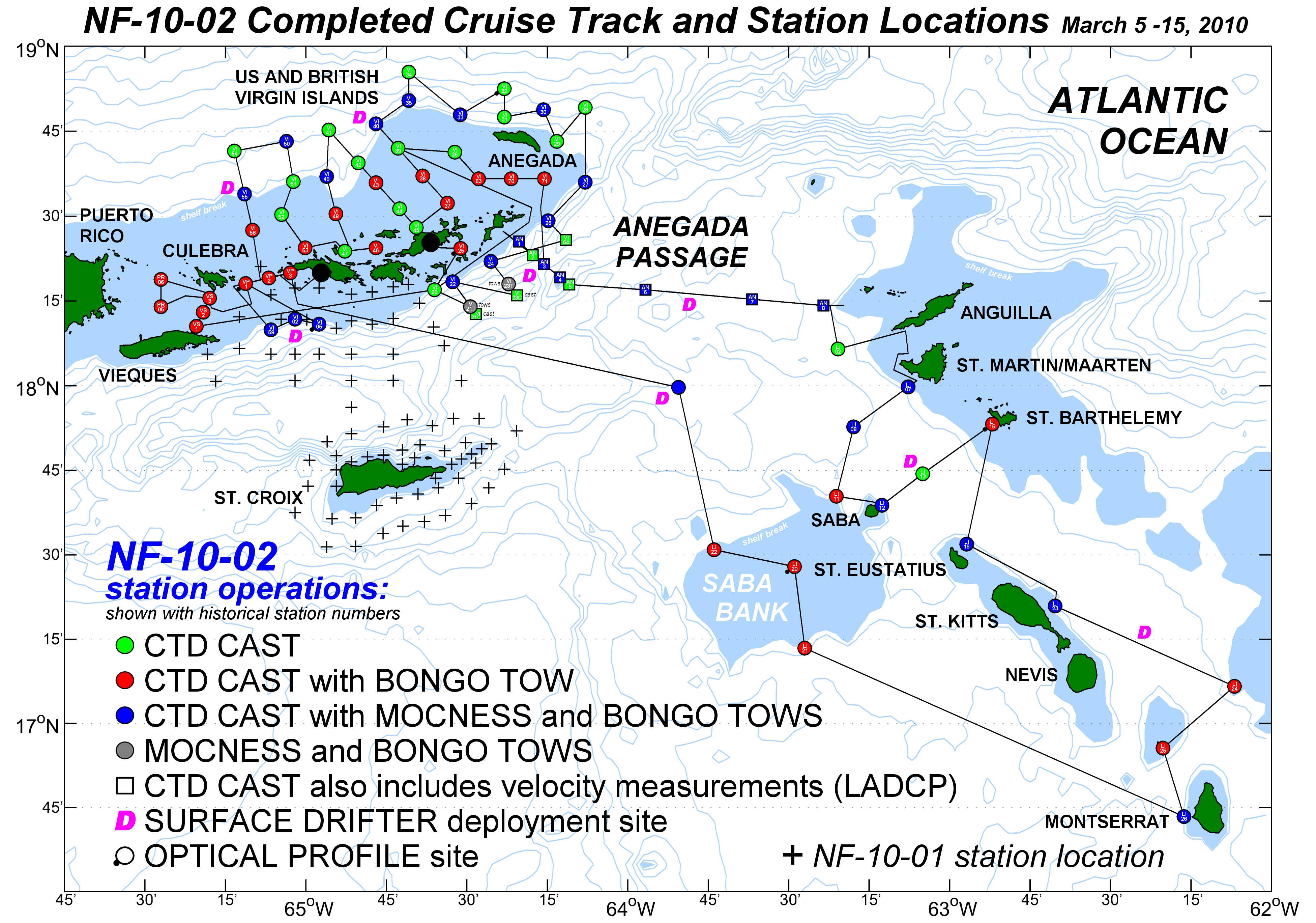
| Document | NF-10-02 cruise track Map with Gear Shown |
| Entity | NF1001 SADCP surface current velocities |
| Document | NF1001_NF1002_FISH_DATA_REPORT.doc |
| Entity | NF1001_NF1002_FISH_DATA_REPORT.xls |
| Entity | NF1001_and_NF1002_TSG.xls |
| Document | NF1001_and_NF1002_drifters_and_moorings_list.pdf |
| Document | NF1001_and_NF1002_sampling_stations_list.pdf |
| Document | readme_NF-1001andNF-1002.pdf |
URLs
URL 1
| URL: | https://www.ncei.noaa.gov/archive/accession/0273560/1.1/data/0-data/NF1001_State_Dept_CD/NF1001_cruise_track.jpg |
|---|---|
| Name: | Cruise With Gear NF-10-01 |
| URL Type: |
Browse Graphic
|
URL 2
| URL: | https://www.ncei.noaa.gov/archive/accession/0273560/1.1/data/0-data/NF1001_State_Dept_CD/NF1002_cruise_track.jpg |
|---|---|
| Name: | Cruise With Gear NF-10-02 |
| URL Type: |
Browse Graphic
|
Child Items
Rubric scores updated every 15m
| Type | Title |
|---|---|
| Entity | CTD Data 2010 |
| Document | CTD Data 2010 Graphs |
| Document | DOS-2009-107_report.pdf |
| Entity | LADCP Data 2010 |
| Document | NF-10-01 cruise track Map with Gear Shown |
| Document | NF-10-02 cruise track Map with Gear Shown |
| Entity | NF1001 SADCP surface current velocities |
| Document | NF1001_NF1002_FISH_DATA_REPORT.doc |
| Entity | NF1001_NF1002_FISH_DATA_REPORT.xls |
| Entity | NF1001_and_NF1002_TSG.xls |
| Document | NF1001_and_NF1002_drifters_and_moorings_list.pdf |
| Document | NF1001_and_NF1002_sampling_stations_list.pdf |
| Document | readme_NF-1001andNF-1002.pdf |