Depth soundings from a single beam echo sounder collected around the nearshore areas of Timor-Leste in 2012 and 2013
Data Set (DS) | Pacific Islands Fisheries Science Center (PIFSC)GUID: gov.noaa.nmfs.inport:25307 | Updated: October 3, 2024 | Published / External
Summary
Short Citation
Pacific Islands Fisheries Science Center, 2025: Depth soundings from a single beam echo sounder collected around the nearshore areas of Timor-Leste in 2012 and 2013, https://www.fisheries.noaa.gov/inport/item/25307.
Full Citation Examples
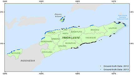
This dataset contains singlebeam bathymetry data acquired during small-boat surveys conducted from October 20-26, 2012 and June 4-27, 2013 in Timor-Leste by the NOAA Coral Reef Ecosystem Program (CREP). Data was acquired with a HydroLite-TM Echosounder Kit by Seafloor Systems, a small boat Hydro Survey System using Ohmex SonarMite echosounder and Trimble ProXT receiver. The singlebeam bathymetry was used to ground-truth bathymetry derived from WorldView-2 satellite imagery by CREP for the near-shore areas (0-20 m depths) around Timor-Leste.
Distribution Information
-
Depth soundings collected during small-boat surveys around the nearshore areas of Timor-leste by the NOAA Coral Reef Ecosystem Program in Oct 2012 and June 2013. Archived with the NCEI Trackline Geophysical Data portal (search by survey/mission id SBP1215 or SBP1310).
None
Please cite NOAA Coral Reef Ecosystem Program (CREP) when using the data.
Example
Coral Reef Ecosystem Program; Pacific Islands Fisheries Science Center (2017). Singlebeam bathymetry for Timor-Leste (2012 and 2013). NOAA's National Centers for Environmental Information. Dataset. https://www.fisheries.noaa.gov/inport/item/25307
Controlled Theme Keywords
elevation
Child Items
| Type | Title |
|---|---|
| Entity | Singlebeam_Timor_Entities |
URLs
URL 1
| URL: | https://www.coris.noaa.gov/activities/projects/timor-leste/ |
|---|---|
| URL Type: |
Online Resource
|
| Description: |
Timor-Leste project portal on the NOAA Coral Reef Information Service website where NOAA's final report for Timor-Leste and the datasets generated by NOAA CREP as part of the project can be downloaded. |
URL 2
| URL: | https://www.coris.noaa.gov/activities/projects/timor-leste/images/ground_truth_s.jpg |
|---|---|
| URL Type: |
Browse Graphic
|
| Description: |
Map of the singlebeam bathymetry data collected around Timor-Leste by the NOAA Coral Reef Ecosystem Program. |
URL 3
| URL: | https://www.pifsc.noaa.gov/cred/coral_triangle_initiative.php |
|---|---|
| URL Type: |
Online Resource
|
| Description: |
Information about the NOAA Coral Reef Ecosystem Program's activities in the Coral Triangle. |
Child Items
Rubric scores updated every 15m
| Type | Title |
|---|---|
| Entity | Singlebeam_Timor_Entities |