WorldView-2 Satellite Image Inventory for Timor-Leste
Data Set (DS) | Pacific Islands Fisheries Science Center (PIFSC)GUID: gov.noaa.nmfs.inport:46151 | Updated: October 3, 2024 | Published / External
Summary
Short Citation
Pacific Islands Fisheries Science Center, 2025: WorldView-2 Satellite Image Inventory for Timor-Leste, https://www.fisheries.noaa.gov/inport/item/46151.
Full Citation Examples
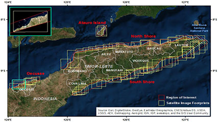
Inventory of satellite images from DigitalGlobe’s WorldView-2 satellite purchased by the NOAA Coral Reef Ecosystem Program for Timor-leste from Jan 26, 2010 to August 10, 2014. Images were acquired for purposes of deriving seafloor depths and benthic habitat classes for the nearshore waters (< 20m depths) of Timor-leste. In addition to the inventory, the dataset includes the regions of interest (ROI) defined by NOAA used to define the geographic areas to acquire the satellite images from DigitalGlobe, the boundary extent of the available images within each ROI, and the footprint (extent) of each image. The data within each satellite image is clipped to the ROI. The ROI, boundary, and footprint files are provided in shapefile format, and the inventory is provided as a text file, which corresponds to the footprints shapefile.
Distribution Information
-
Shapefile
The boundary (extent) of the available WorldView-2 satellite images purchased by NOAA for each region in TImor-leste, including the north and south coastlines, the Island of Atauro, and the district of Oecusse.
-
Shapefile
The footprint (extent) for each WorldView-2 satellite image purchased by NOAA for Timor-leste within the boundary/region of interest.
-
CSV - Comma Separated Values (Text)
The inventory includes attributes about the WorldView-2 satellite images purchased by NOAA for Timor-leste, and corresponds to the footprints shapefile.
-
Shapefile
The regions of interest (ROI) were used by NOAA to define the desired geographic areas in Timor-leste to purchase the WorldView-2 satellite imagery from DigitalGlobe. Images were acquired along the coasts of the four identified regions of interest (Atauro, North shore, Oecusse, and South shore).The ROI was used by DigitalGlobe to clip the data within each satellite image.
WorldView-2 imagery cannot be publicly redistributed per the license agreement with DigitalGlobe. Contact the NOAA Coral Reef Ecosystem Program for specific questions about the source imagery for TImor-leste at nmfs.pic.credinfo@noaa.gov.
Please cite NOAA Coral Reef Ecosystem Program (CREP) when using the data.
Example
Coral Reef Ecosystem Program; Pacific Islands Fisheries Science Center (2017). WorldView-2 Satellite Image Inventory for Timor-Leste. NOAA's National Center for Environmental Information. Dataset. https://www.fisheries.noaa.gov/inport/item/46151
Controlled Theme Keywords
imageryBaseMapsEarthCover, oceans
Child Items
| Type | Title |
|---|---|
| Entity | WV-2_image_inventory |
URLs
URL 1
| URL: | https://www.coris.noaa.gov/activities/projects/timor-leste/ |
|---|---|
| URL Type: |
Online Resource
|
| Description: |
Timor-Leste project portal on the NOAA Coral Reef Information Service website where NOAA's final report for Timor-Leste and the datasets generated by NOAA CREP as part of the project can be downloaded. |
URL 2
| URL: | https://www.pifsc.noaa.gov/cred/coral_triangle_initiative.php |
|---|---|
| URL Type: |
Online Resource
|
| Description: |
Information about the NOAA Coral Reef Ecosystem Program's activities in the Coral Triangle. |
URL 3
| URL: | https://www.coris.noaa.gov/activities/projects/timor-leste/images/image_catalog_s.jpg |
|---|---|
| URL Type: |
Browse Graphic
|
| File Resource Format: | jpg |
| Description: |
The WorldView-2 satellite image inventory for Timor-Leste, showing the extents of each satellite image and the regions of interest. |
Child Items
Rubric scores updated every 15m
| Type | Title |
|---|---|
| Entity | WV-2_image_inventory |