Satellite-derived bathymetry for nearshore benthic habitats in Timor-Leste
Data Set (DS) | Pacific Islands Fisheries Science Center (PIFSC)GUID: gov.noaa.nmfs.inport:46150 | Updated: October 3, 2024 | Published / External
Summary
Short Citation
Pacific Islands Fisheries Science Center, 2025: Satellite-derived bathymetry for nearshore benthic habitats in Timor-Leste, https://www.fisheries.noaa.gov/inport/item/46150.
Full Citation Examples
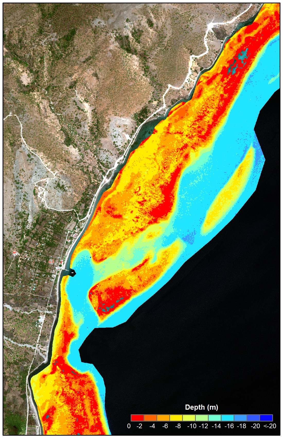
Bathymetric data derived from multispectral, high-resolution (2 m) satellite imagery from DigitalGlobe’s WorldView-2 satellite to provide near complete coverage of nearshore terrain along the northern coastline of Timor-Leste, including the district of Oecusse to the west of mainland Timor-Leste and Atauro Island. Satellite images acquired by the NOAA Coral Reef Ecosystem Program (CREP) for the region are from Feb 9, 2010 to October 2, 2013. Methods used by CREP to estimate depths from the WorldView imagery were adapted from instructions developed by Kyle Hogrefe for using IKONOS imagery to derive seafloor elevations in optically clear water (Ehses and Rooney 2015).
Bathymetry values shallower than ~20 m were derived by gauging the relative attenuation of coastal, blue, green and yellow spectral radiance as a function of depth. A multiple linear regression analysis of coastal, blue, green and yellow band spectral values against in-situ depth determined the variables of y-intercept, coastal, blue, green and yellow slope values. The variables for each band were then used in a multivariate slope intercept equation to derive depth over the imagery. Variables and combinations of the bands were adjusted to improve the statistical accuracy and spatial coverage of the final derived bathymetry product. Digital image processing to derive depths was conducted with ENVI, and editing and integration was performed using Esri's ArcGIS.
The method assumes uniform water clarity but deviations from that condition made extraction difficult in water depths greater than 20 m. Results show that biotic material, or sediment in the water column skewed results shallower if the material has a high albedo and deeper if the material has a low albedo.
Distribution Information
-
GeoTIFF
GeoTiff raster bathymetry data for nearshore waters of Timor Leste, derived from WorldView-2 satellite imagery. The bathymetry data are organized by region (north shore, Atauro Island, and Oecusse), and each region contains 1) the individual final bathymetry files (one geoTiff for each satellite image), 2) a projected (UTM_Zone_51S) bathymetry mosaic for the region, and 3) an unprojected (WGS84) mosaic for the region. The mosaics are also in geoTiff format. An ESRI layer file is included within each region's subfolder for ease of displaying the geoTiffs in ESRI's ArcGIS software. The symbology is based on the VALUE field.
-
Text (Unstructured)
README folder contains the README.txt files for each final bathymetry geoTiff produced for the three regions (north shore, Atauro Island, and Oecusse) of Timor-Leste. Each README.txt file contains specific details for each geoTiff generated.
-
PDF - Adobe Portable Document Format
Depth Derivation Using Multispectral WorldView-2 Satellite Imagery, a NOAA tech memo published by the Pacific Islands Fisheries Science Center. The Tech Memo is also available in the NOAA Repository.
None
Please cite NOAA Coral Reef Ecosystem Program (CREP) when using the data.
Example
Coral Reef Ecosystem Program; Pacific Islands Fisheries Science Center (2017). Satellite-derived bathymetry for nearshore benthic habitats in Timor-Leste. NOAA's National Centers for Environmental Information. Dataset. https://www.fisheries.noaa.gov/inport/item/46150
Controlled Theme Keywords
elevation
Child Items
| Type | Title |
|---|---|
| Entity | WV2_Bathy_TIMOR |
URLs
URL 1
| URL: | https://www.coris.noaa.gov/activities/projects/timor-leste/ |
|---|---|
| URL Type: |
Online Resource
|
| File Resource Format: | HTML |
| Description: |
Timor-Leste project portal on the NOAA Coral Reef Information Service website where NOAA's final report for Timor-Leste and the datasets generated by NOAA CREP as part of the project can be downloaded. |
URL 2
| URL: | https://dg-cms-uploads-production.s3.amazonaws.com/uploads/document/file/35/DG-8SPECTRAL-WP_0.pdf |
|---|---|
| URL Type: |
Online Resource
|
| File Resource Format: | |
| Description: |
DigitalGlobe. 2010. The Benefits of the Eight Spectral Bands of WorldView-2. |
URL 3
| URL: | https://dg-cms-uploads-production.s3.amazonaws.com/uploads/document/file/98/WorldView2-DS-WV2-rev2.pdf |
|---|---|
| URL Type: |
Online Resource
|
| File Resource Format: | |
| Description: |
WorldView-2 Data Sheet |
URL 4
| URL: | https://www.coris.noaa.gov/activities/projects/timor-leste/images/bathymetry.jpg |
|---|---|
| URL Type: |
Browse Graphic
|
| File Resource Format: | JPG |
| Description: |
An example of the bathymetry data generated for Timor-Leste from WorldView-2 satellite imagery. |
URL 5
| URL: | https://www.pifsc.noaa.gov/cred/coral_triangle_initiative.php |
|---|---|
| URL Type: |
Online Resource
|
| File Resource Format: | PHP |
| Description: |
Information about the NOAA Coral Reef Ecosystem Program's activities in the Coral Triangle. |
Child Items
Rubric scores updated every 15m
| Type | Title |
|---|---|
| Entity | WV2_Bathy_TIMOR |