Benthic percent cover derived from analysis of benthic images collected at coral reef sites in Timor-Leste in 2013 and 2014
Data Set (DS) | Pacific Islands Fisheries Science Center (PIFSC)GUID: gov.noaa.nmfs.inport:46161 | Updated: May 30, 2023 | Published / External
Item Identification
Title: | Benthic percent cover derived from analysis of benthic images collected at coral reef sites in Timor-Leste in 2013 and 2014 |
---|---|
Short Name: | Timor: Benthic Cover 2013-2014 |
Status: | Completed |
Publication Date: | 2017 |
Abstract: |
The benthic cover data described here result from benthic photo-quadrat surveys conducted by the NOAA Coral Reef Ecosystem Program (CREP) in hard bottom shallow water (< 15 m) habitats in Timor-Leste during reef fish surveys surveys at 150 sites that were selected using a stratified random sampling design in June 2013, and along transects at fixed climate survey sites in September-October 2014 (10 sites and 8 sites, respectively). Climate sites were established by CREP to establish ecological baselines for climate change by measuring multiple features of the coral reef environment (in addition to the data described herein) over time. The reef fish surveys were conducted to generate baseline data on the nearshore coral reef fish assemblages and associated benthic communities around Timor-Leste's north coast and Atauro Island. Percent benthic cover for each site is estimated from a photo-transect (30 photographs, taken at 1-m intervals, 10+ points analyzed per photograph using Coral Point Count with Extensions). NA values represent situations where images were either not gathered or not analyzed. These benthic cover data for Timor-Leste provide an estimate of the benthic community composition at each survey site, and give context to the results from the other survey components. The benthic images, and the associated reef fish survey data and parameters measured to establish ecological baselines for climate change are documented separately. The data can be accessed online via the NOAA National Centers for Environmental Information (NCEI) Ocean Archive. |
Purpose: |
In 2011, NOAA and the United States Agency for International Development (USAID) Timor-Leste Mission formed a 5-year bi-lateral partnership agreement from 2012 to 2016, in support of the Government of Timor-Leste—particularly the Ministry of Agriculture and Fisheries (MAF)—by addressing significant information gaps in their nearshore marine ecosystems. Specifically, MAF asked NOAA to address the following questions: 1. Where are the nearshore marine resources? 2. What are the nearshore marine resources? 3. How are they changing over time and what threats are potentially causing these changes? 4. What approaches are needed to manage and conserve the nearshore marine resources? With financial support from USAID and in-kind support from the NOAA Coral Reef Conservation Program (CRCP), the NOAA Coral Reef Ecosystem Program (NOAA-CREP) conducted baseline ecosystem assessment surveys to inform ecosystem-based management planning in Timor-Leste. The primary activities conducted by NOAA to answer these questions included: 1. satellite mapping of nearshore habitats, 2. conducting coral reef ecosystem assessments, 3. establishing ecological baselines for climate change, and 4. building management capacity by developing a spatial data framework The benthic cover data described herein resulted from the second and third activities to conduct coral reef ecosystem assessments (2013) and establish ecological baselines for climate change (2014). |
Other Citation Details: |
Pacific Islands Fisheries Science Center. 2017. Interdisciplinary baseline ecosystem assessment surveys to inform ecosystem-based management planning in Timor-Leste: Final Report. Pacific Islands Fisheries Science Center, PIFSC Special Publication, SP-17-002, 234 p. https://doi.org/10.7289/V5/SP-PIFSC-17-002. |
Supplemental Information: |
As the survey methods described and used herein are also implemented as part of the NOAA Pacific Reef Assessment and Monitoring Program (Pacific RAMP)—an ecosystem-scale interdisciplinary coral reef monitoring program—the data from Timor-Leste are directly comparable to and informed by data collected by NOAA-CREP throughout the U.S. Pacific Islands and Territories. Furthermore, the methods used for establishing ecological baselines for climate change in Timor-Leste (Chapter 4) are being adopted and implemented at 21 sites across eight member states of the Intergovernmental Oceanographic Commission within the Western Pacific (WESTPAC) region. These data provide a foundation for comparing the ecological baselines under current and future stresses associated with climate change in the Coral Triangle region. |
Keywords
Theme Keywords
Thesaurus | Keyword |
---|---|
ISO 19115 Topic Category |
biota
|
UNCONTROLLED | |
CoRIS Discovery Thesaurus | Numeric Data Sets > Benthic |
CoRIS Theme Thesaurus | EARTH SCIENCE > Biosphere > Aquatic Habitat > Benthic Habitat |
CoRIS Theme Thesaurus | EARTH SCIENCE > Biosphere > Aquatic Habitat > Reef Habitat |
CoRIS Theme Thesaurus | EARTH SCIENCE > Biosphere > Microbiota > Blue-green Algae |
CoRIS Theme Thesaurus | EARTH SCIENCE > Biosphere > Vegetation > Algae > Algal Cover |
CoRIS Theme Thesaurus | EARTH SCIENCE > Biosphere > Vegetation > Algae > Crustose Coralline Algae |
CoRIS Theme Thesaurus | EARTH SCIENCE > Biosphere > Vegetation > Algae > Encrusting Macroalgae |
CoRIS Theme Thesaurus | EARTH SCIENCE > Biosphere > Vegetation > Algae > Turf Algae |
CoRIS Theme Thesaurus | EARTH SCIENCE > Biosphere > Zoology > Corals |
CoRIS Theme Thesaurus | EARTH SCIENCE > Biosphere > Zoology > Corals > Reef Monitoring and Assessment |
CoRIS Theme Thesaurus | EARTH SCIENCE > Biosphere > Zoology > Corals > Reef Monitoring and Assessment > Baseline studies |
CoRIS Theme Thesaurus | EARTH SCIENCE > Biosphere > Zoology > Corals > Reef Monitoring and Assessment > Benthos Analysis |
CoRIS Theme Thesaurus | EARTH SCIENCE > Biosphere > Zoology > Corals > Reef Monitoring and Assessment > Benthos Analysis > Quadrat Monitoring > Photograph Analysis |
CoRIS Theme Thesaurus | EARTH SCIENCE > Biosphere > Zoology > Corals > Reef Monitoring and Assessment > In Situ Biological |
CoRIS Theme Thesaurus | EARTH SCIENCE > Biosphere > Zoology > Corals > Reef Monitoring and Assessment > Photographic Analysis |
CoRIS Theme Thesaurus | EARTH SCIENCE > Oceans > Coastal Processes > Coral Reefs |
CoRIS Theme Thesaurus | EARTH SCIENCE > Oceans > Coastal Processes > Coral Reefs > Coral Reef Ecology |
CoRIS Theme Thesaurus | EARTH SCIENCE > Oceans > Coastal Processes > Coral Reefs > Coral Reef Ecology > Benthic biology |
CoRIS Theme Thesaurus | EARTH SCIENCE > Oceans > Coastal Processes > Coral Reefs > Coral Reef Ecology > Coral Cover |
CoRIS Theme Thesaurus | EARTH SCIENCE > Oceans > Coastal Processes > Coral Reefs > Coral Reef Ecology > Hard Coral Cover |
CoRIS Theme Thesaurus | EARTH SCIENCE > Oceans > Coastal Processes > Coral Reefs > Coral Reef Ecology > Octocoral Cover |
CoRIS Theme Thesaurus | EARTH SCIENCE > Oceans > Marine Biology > Coral |
CoRIS Theme Thesaurus | EARTH SCIENCE > Oceans > Marine Biology > Coral Communities |
CoRIS Theme Thesaurus | EARTH SCIENCE > Oceans > Marine Biology > Marine Invertebrates |
NODC DATA TYPES THESAURUS | REEF AND/OR BOTTOM REGIME - PERCENT COVER |
NODC OBSERVATION TYPES THESAURUS | Derived products |
NODC PROJECT NAMES THESAURUS | CORAL REEF STUDIES |
NODC PROJECT NAMES THESAURUS | Coral Triangle Initiative |
NODC SUBMITTING INSTITUTION NAMES THESAURUS | US DOC; NOAA; NMFS; Pacific Islands Fisheries Science Center; Ecosystem Sciences Division; Coral Reef Ecosystem Program |
None | Coral Reef Ecosystem Division |
None | Coral Reef Ecosystem Program |
None | CRED |
None | CREP |
None | Pacific Islands Fisheries Science Center |
None | PIFSC |
None | United States Agency for International Development |
None | USAID |
Spatial Keywords
Thesaurus | Keyword |
---|---|
UNCONTROLLED | |
CoRIS Place Thesaurus | COUNTRY/TERRITORY > Democratic Republic of Timor-Leste (East Timor) (09S126E0001) |
CoRIS Place Thesaurus | OCEAN BASIN > Indian Ocean > Timor Sea > Democratic Republic of Timor-Leste (East Timor) (09S126E0001) |
NODC Sea Area Names Thesaurus | Indian Ocean |
NODC Sea Area Names Thesaurus | Timor Sea |
None | Atauro |
None | Baucau |
None | Bobonaro |
None | Dili |
None | Lautem |
None | Liquica |
None | Manatuto |
None | Oecusse |
None | Timor-Leste |
None | Vila MPA |
Physical Location
Organization: | Pacific Islands Fisheries Science Center |
---|---|
City: | Honolulu |
State/Province: | HI |
Country: | USA |
Data Set Information
Data Set Scope Code: | Data Set |
---|---|
Data Set Type: | CSV Files |
Maintenance Frequency: | None Planned |
Data Presentation Form: | Table (digital) |
Entity Attribute Overview: |
The benthic classification tiers, categories, and definitions are included in the entities and attributes section, including descriptions for hard (CORAL) and soft coral (SC), crustose coralline algae (CCA), macroalgae and seagrass (MA), turf algae (TURF), sediment (SED), sessile invertebrates (I), mobile fauna (MF), and unclassified (UC). Additionally, the definitions for each attribute provided in the dataset are included. |
Distribution Liability: |
While every effort has been made to ensure that these data are accurate and reliable within the limits of the current state of the art, NOAA cannot assume liability for any damages caused by errors or omissions in the data, nor as a result of the failure of the data to function on a particular system. NOAA makes no warranty, expressed or implied, nor does the fact of distribution constitute such a warranty. |
Data Set Credit: | PIFSC Coral Reef Ecosystem Program and funded by the United States Agency for International Development |
Support Roles
Data Steward
Date Effective From: | 2013 |
---|---|
Date Effective To: | |
Contact (Person): | Vargas-Angel, Bernardo |
Address: |
1845 Wasp Blvd. Honolulu, HI 96818 USA |
Email Address: | bernardo.vargasangel@noaa.gov |
Phone: | (808)725-5423 |
Contact Instructions: |
Email preferred |
Distributor
Date Effective From: | 2017 |
---|---|
Date Effective To: | |
Contact (Organization): | National Centers for Environmental Information - Silver Spring, Maryland (NCEI-MD) |
Address: |
NOAA/NESDIS E/OC SSMC3, 4th Floor, 1351 East-West Highway Silver Spring, MD 20910-3282 |
Phone: | (301) 713-3277 |
Metadata Contact
Date Effective From: | 2013 |
---|---|
Date Effective To: | |
Contact (Person): | DesRochers, Annette M |
Address: |
1845 Wasp Blvd. Honolulu, HI 96818 USA |
Email Address: | annette.desrochers@noaa.gov |
Phone: | (808)725-5461 |
Business Hours: | 8 am - 5 pm |
Contact Instructions: |
Email preferred |
Originator
Date Effective From: | 2013 |
---|---|
Date Effective To: | |
Contact (Organization): | Pacific Islands Fisheries Science Center (PIFSC) |
Address: |
1845 Wasp Blvd. Honolulu, HI 96818 USA |
Email Address: | pifsc.info@noaa.gov |
Phone: | 808-725-5360 |
URL: | https://www.pifsc.noaa.gov |
Business Hours: | 8:00 a.m. - 4:30 p.m. |
Point of Contact
Date Effective From: | 2013 |
---|---|
Date Effective To: | |
Contact (Person): | Vargas-Angel, Bernardo |
Address: |
1845 Wasp Blvd. Honolulu, HI 96818 USA |
Email Address: | bernardo.vargasangel@noaa.gov |
Phone: | (808)725-5423 |
Contact Instructions: |
Email preferred |
Extents
Currentness Reference: | Ground Condition |
---|
Extent Group 1
Extent Description: |
Timor-Leste |
---|
Extent Group 1 / Geographic Area 1
W° Bound: | 124 | |
---|---|---|
E° Bound: | 127.5 | |
N° Bound: | -8.1 | |
S° Bound: | -9.5 | |
Description |
Extent of photo-quadrat surveys conducted by NOAA CREP in Timor-Leste in 2013 and 2014. |
Extent Group 1 / Time Frame 1
Time Frame Type: | Range |
---|---|
Start: | 2013-06-04 |
End: | 2013-06-27 |
Alternate Start As Of Info: | SB1310 |
Description: |
Time frame of reef fish surveys conducted by NOAA CREP at Timor-Leste in June 2013. |
Extent Group 1 / Time Frame 2
Time Frame Type: | Range |
---|---|
Start: | 2014-09-16 |
End: | 2014-10-09 |
Alternate Start As Of Info: | MP-14-19 |
Description: |
Time frame of climate change surveys in 2014. |
Access Information
Security Class: | Unclassified |
---|---|
Security Classification System: |
Not applicable |
Security Handling Description: |
Not applicable |
Data Access Policy: |
NOAA Coral Reef Ecosystem Program (CREP) Data Sharing Recommendations, version 9.0 updated August 12, 2015: CREP welcomes the opportunity to collaborate on research issues contributing to the scientific basis for better management of marine ecosystems. CREP has a very diverse set of field activities that generates large volumes of data using an array of data collection protocols. The following recommendations are for your consideration as you use this data: 1) Data analyses should take all field exigencies into account. The most effective way to do this would be active collaboration with CREP principal investigators. 2) In all presentations, product releases, or publications using data generated by CREP, proper acknowledgement of both CREP and the individuals responsible for data collection is expected. Citing the DOI (if available) is preferred, a non-DOI example is listed below. 3) If you collect or generate data for the same study areas, CREP requests that you share relevant information on complimentary data collections. 4) Those receiving data are strongly urged to inform the CREP Data Management Team of any errors and discrepancies that are discovered during the course of using these data. They are further urged to bring to the attention of the Team all problems and difficulties encountered in using these data. This information is necessary in order to improve the collections and to facilitate more efficient and economical data processing and retrieval. The users are asked to supply copies of any missing data that may be located, and to provide information as to significant subsets and special aggregations of data that are developed in using the material provided. Example citation: "This publication makes use of data products provided by the Coral Reef Ecosystem Program (CREP), Pacific Islands Fisheries Science Center (PIFSC), National Marine Fisheries Service (NMFS), National Oceanic and Atmospheric Administration (NOAA), with funding support from the United States Agency for International Development. The analysis and interpretations presented here are solely that of the current authors.” |
Data Access Procedure: |
Data can be accessed online via the NOAA National Centers for Environmental Information (NCEI) Ocean Archive. |
Data Access Constraints: |
None |
Data Use Constraints: |
Please cite NOAA Coral Reef Ecosystem Program (CREP) when using the data. Example: Coral Reef Ecosystem Program; Pacific Islands Fisheries Science Center (2017). Benthic percent cover derived from analysis of benthic images collected at coral reef sites in Timor-Leste in 2013 and 2014. NOAA's National Center for Environmental Information. Dataset. https://www.fisheries.noaa.gov/inport/item/46161 |
Metadata Access Constraints: |
None |
Metadata Use Constraints: |
None |
Distribution Information
Distribution 1
Download URL: | https://accession.nodc.noaa.gov/0168620 |
---|---|
Distributor: | National Centers for Environmental Information - Silver Spring, Maryland (NCEI-MD) (2017 - Present) |
File Name: | Benthic_Cover_Code_Categories.csv |
Description: |
Benthic cover classification codes (definitions included in entities and attributes section). |
File Type: | csv (comma-separated values) |
Distribution 2
Download URL: | https://accession.nodc.noaa.gov/0168620 |
---|---|
Distributor: | National Centers for Environmental Information - Silver Spring, Maryland (NCEI-MD) (2017 - Present) |
File Name: | Benthic_Cover_PhotoPoints_ClimateSites_2014.csv |
Description: |
Image analysis data derived from photoquadrat benthic images collected by the NOAA Coral Reef Ecosystem Program (CREP) at climate survey sites in Timor-Leste in 2014. File contains data for each point analyzed for a photograph (10 points each site). Habitat information (HABITAT_CODE) was not recorded. |
File Type: | csv (comma-separated values) |
Distribution 3
Download URL: | https://accession.nodc.noaa.gov/0168620 |
---|---|
Distributor: | National Centers for Environmental Information - Silver Spring, Maryland (NCEI-MD) (2017 - Present) |
File Name: | Benthic_Cover_PhotoPoints_FishSites_2013.csv |
Description: |
Image analysis data derived from photoquadrat benthic images collected by the NOAA Coral Reef Ecosystem Program (CREP) at reef fish survey sites in Timor-Leste in 2013. File contains data for each point analyzed for a photograph (10 points each site). |
File Type: | csv (comma-separated values) |
Distribution 4
Download URL: | https://accession.nodc.noaa.gov/0168620 |
---|---|
Distributor: | National Centers for Environmental Information - Silver Spring, Maryland (NCEI-MD) (2017 - Present) |
File Name: | Benthic_Cover_Photo_ClimateSites_Timor_2014.csv |
Description: |
Image analysis data derived from photoquadrat benthic images collected by the NOAA Coral Reef Ecosystem Program (CREP) at climate survey sites in Timor-Leste in 2014. File summarizes data for each photograph analyzed (one record = 1 photograph = data from 10 points analyzed) |
File Type: | csv (comma-separated values) |
Distribution 5
Download URL: | https://accession.nodc.noaa.gov/0168620 |
---|---|
Distributor: | National Centers for Environmental Information - Silver Spring, Maryland (NCEI-MD) (2017 - Present) |
File Name: | Benthic_Cover_Photo_FishSites_Timor_2013.csv |
Description: |
Image analysis data derived from photoquadrat benthic images collected by the NOAA Coral Reef Ecosystem Program (CREP) at reef fish survey sites in Timor-Leste in 2013. File summarizes data for each photograph analyzed (one record = 1 photograph = data from 10 points analyzed) |
File Type: | csv (comma-separated values) |
Distribution 6
Download URL: | https://accession.nodc.noaa.gov/0168620 |
---|---|
Distributor: | National Centers for Environmental Information - Silver Spring, Maryland (NCEI-MD) (2017 - Present) |
File Name: | Benthic_Cover_Site_ClimateSites_Timor_2014.csv |
Description: |
Image analysis data derived from photoquadrat benthic images collected by the NOAA Coral Reef Ecosystem Program (CREP) at climate survey sites in Timor-Leste in 2014. File summarizes data for each survey site (1 record = 1 site = ~30 photographs analyzed). |
File Type: | csv (comma-separated values) |
Distribution 7
Download URL: | https://accession.nodc.noaa.gov/0168620 |
---|---|
Distributor: | National Centers for Environmental Information - Silver Spring, Maryland (NCEI-MD) (2017 - Present) |
File Name: | Benthic_Cover_Site_FishSites_Timor_2013.csv |
Description: |
Image analysis data derived from photoquadrat benthic images collected by the NOAA Coral Reef Ecosystem Program (CREP) at reef fish survey sites in Timor-Leste in 2013. File summarizes data for each survey site (1 record = 1 site = ~30 photographs analyzed). |
File Type: | csv (comma-separated values) |
URLs
URL 1
URL: | http://cnso.nova.edu/cpce/index.html |
---|---|
URL Type: |
Online Resource
|
File Resource Format: | HTML |
Description: |
Coral Point Count with Excel extensions website. |
URL 2
URL: | https://www.coris.noaa.gov/activities/projects/timor-leste/ |
---|---|
URL Type: |
Online Resource
|
File Resource Format: | HTML |
Description: |
Timor-Leste project portal on the NOAA Coral Reef Information Service website where NOAA's final report for Timor-Leste and the datasets generated by NOAA CREP as part of the project can be downloaded. |
URL 3
URL: | https://www.coris.noaa.gov/activities/projects/timor-leste/images/benthic_cover_graph_fish_s.jpg |
---|---|
URL Type: |
Browse Graphic
![]() |
File Resource Format: | JPG |
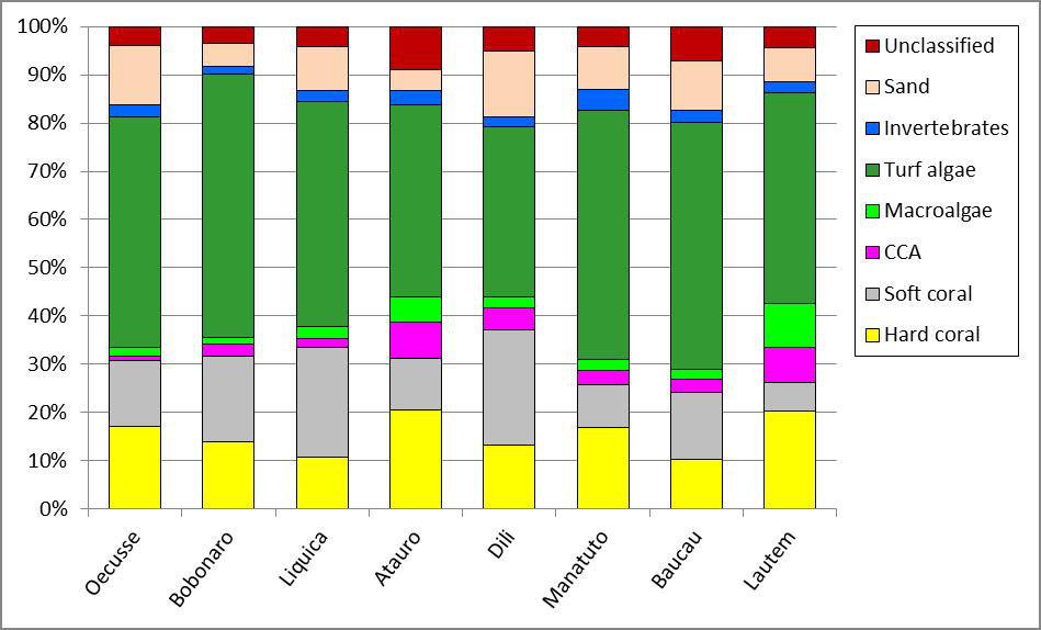
Description: |
An example chart of the benthic cover data for Timor-Leste. |
URL 4
URL: | https://www.pifsc.noaa.gov/cred/coral_triangle_initiative.php |
---|---|
URL Type: |
Online Resource
|
File Resource Format: | PHP |
Description: |
Information about the NOAA Coral Reef Ecosystem Program's activities in the Coral Triangle. |
URL 5
URL: | https://pifscblog.wordpress.com/2013/08/13/final-count-timor-leste-2/ |
---|---|
URL Type: |
Online Resource
|
File Resource Format: | html |
Description: |
PIFSC CREP blog post, 2013: The final count: summary of mission to assess reef fish assemblages, build capacity in Timor-Leste. |
URL 6
URL: | https://pifscblog.wordpress.com/2014/09/30/timor-leste-atauro/ |
---|---|
URL Type: |
Online Resource
|
File Resource Format: | HTML |
Description: |
PIFSC CREP blog post, 2014: Scientists return to Timor-Leste for reef monitoring mission. |
Technical Environment
Description: |
PIFSC Oracle database view: mv_bia_perc_cover_photo_str_rw |
---|
Data Quality
Accuracy: |
Data sets derived from image analysis are highly reliable within the stipulated taxonomic context. Each time a production run is performed for a region, a calibration exercise is conducted by all staff that will participate in that round of image analysis classification. Usually 100-150 photos are selected from the photos being processed as part of the production run series, or other region-relevant photo streams. Then, CPCe assigns 10 random points per photo. Each photo analyst is asked to classify the same set of points in each of the photos used as part of the calibration exercise. The goal of the calibration exercise is to assess inter-observer variability. Inter-observer variability rates are available upon request for each production run. Handheld GPS units were used to locate and mark site locations. |
---|---|
Analytical Accuracy: |
Data sets derived from image analysis include 30 benthic photographs per survey site. Photoquadrat surveys are along one 30 m transect for reef fish surveys. The climate team conducts the surveys along 2 independent transects. Appropriate site level benthic cover estimates are generated from all 30 images. |
Completeness Measure: |
Photoquads were taken at all climate sites surveyed, and at 139 of the 150 fish sites surveyed. |
Completeness Report: |
The data set derived from the image analysis is as good as the images themselves; poor images with low contrast, inappropriate white balance, or out of focus may have to be discarded. Therefore, percent cover estimates for some sites may derive from differing number of points between sites. Although the analysis process is statistically robust to allow for differing n (points) between sites, users should be aware of this limitation. Only shallow water (0 to 30 meter depth range) hard-bottom habitats are surveyed. HABITAT_CODE was not recorded at climate sites. |
Conceptual Consistency: |
The same method of image analysis was used at each surveyed site. |
Quality Control Procedures Employed: |
Quality control is enforced by means of point-to-point, inter-observer calibration exercises that are conducted before each image analysis production series. Training modules and standard operating procedures have also been developed and documented to ensure improved performance and consistent imagery analysis results produced by multiple analysts. |
Data Management
Have Resources for Management of these Data Been Identified?: | Yes |
---|---|
Approximate Percentage of Budget for these Data Devoted to Data Management: | Unknown |
Do these Data Comply with the Data Access Directive?: | Yes |
Is Access to the Data Limited Based on an Approved Waiver?: | No |
Approximate Delay Between Data Collection and Dissemination: | Unknown |
Actual or Planned Long-Term Data Archive Location: | NCEI-MD |
Approximate Delay Between Data Collection and Archiving: | Unknown |
How Will the Data Be Protected from Accidental or Malicious Modification or Deletion Prior to Receipt by the Archive?: |
NOAA IRC and NOAA Fisheries ITS resources and assets. |
Lineage
Lineage Statement: |
The benthic photoquadrat survey methodology, employed by the NOAA Coral Reef Ecosystem Program (CREP) since 2013. Benthic imagery is collected at survey sites and is analyzed using Coral Point Count with Excel Extentions (CPCe) to derive benthic cover values. |
---|
Sources
PIFSC. 2017. Interdisciplinary baseline ecosystem assessment surveys to inform ecosystem-based management planning in Timor-Leste: Final Report. NOAA Pacific Islands Fisheries Science Center, PIFSC Special Publication, SP-17-02, 234p.
Contact Type: | Organization |
---|---|
Contact Name: | Pacific Islands Fisheries Science Center, PIFSC |
Publish Date: | 2017-06-21 |
Citation URL: | https://doi.org/10.7289/V5/SP-PIFSC-17-002 |
Process Steps
Process Step 1
Description: |
The benthic photoquadrat imagery were analyzed using Coral Point Count with Excel extensions (CPCe; Kohler and Gill 2006) software. CPCe assigns 10 random points per photo and the benthic elements falling directly underneath each point is identified to two functional group levels: Tier 1 (e.g. hard coral, soft coral, macroalgae, turf algae, etc.) and Tier 2 (e.g. Hard coral by morphology = massive, branching, foliose, encrusting, etc.; Macroalgae = upright macroalgae, encrusting macroalgae, bluegreen macroalgae, and Halimeda, etc.). The detailed list of each functional group level or tier is included in the benthic image analysis classification scheme. |
---|---|
Source: | PIFSC. 2017. Interdisciplinary baseline ecosystem assessment surveys to inform ecosystem-based management planning in Timor-Leste: Final Report. NOAA Pacific Islands Fisheries Science Center, PIFSC Special Publication, SP-17-02, 234p. |
Process Step 2
Description: |
Raw survey data includes unique image name and individual point observations identified at two functional group levels of benthic cover with the corresponding physical data which reflect the description of the site. The physical data for all records includes the following: region, island, site, date (day, month, year), latitude (dd), longitude (dd), reef zone, habitat type, depth category, minimum depth and maximum depth. |
---|
Child Items
Rubric scores updated every 15m
Type | Title |
---|---|
Entity | Benthic Image analysis classification scheme |
Entity | Table: BIA_PERC_COVER_PHOTO_TIMOR |
Catalog Details
Catalog Item ID: | 46161 |
---|---|
GUID: | gov.noaa.nmfs.inport:46161 |
Metadata Record Created By: | Annette M DesRochers |
Metadata Record Created: | 2017-06-02 03:18+0000 |
Metadata Record Last Modified By: | SysAdmin InPortAdmin |
Metadata Record Last Modified: | 2023-05-30 18:10+0000 |
Metadata Record Published: | 2017-11-20 |
Owner Org: | PIFSC |
Metadata Publication Status: | Published Externally |
Do Not Publish?: | N |
Metadata Last Review Date: | 2017-11-20 |
Metadata Review Frequency: | 1 Year |
Metadata Next Review Date: | 2018-11-20 |