Nearshore Benthic Habitats of Timor-Leste Derived from WorldView-2 Satellite Imagery
Data Set (DS) | Pacific Islands Fisheries Science Center (PIFSC)GUID: gov.noaa.nmfs.inport:29128 | Updated: October 17, 2023 | Published / External
Summary
Short Citation
Pacific Islands Fisheries Science Center, 2024: Nearshore Benthic Habitats of Timor-Leste Derived from WorldView-2 Satellite Imagery, https://www.fisheries.noaa.gov/inport/item/29128.
Full Citation Examples
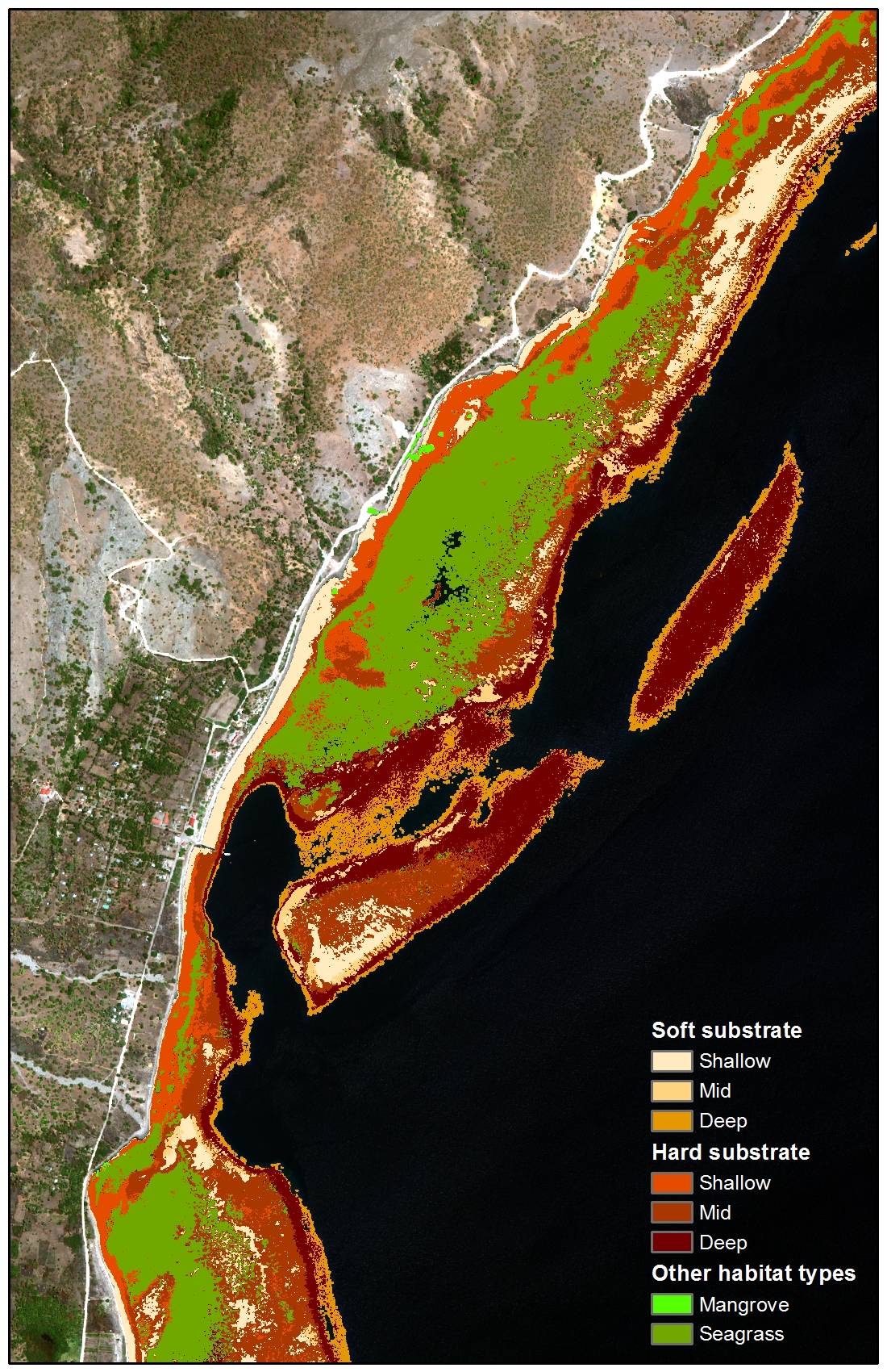
Benthic habitat classes were derived for nearshore waters (< 20 m depths) around Timor-Leste from DigitalGlobe WorldView-2 satellite imagery, acquired from February 9, 2010 to December 14, 2013, by the NOAA Coral Reef Ecosystem Program (CREP). Habitat classes include soft (sand or mud) and hard (rubble, boulders, etc.) substrates by depth (shallow, mid and deep); seagrass, mangrove, and macroalgae dominated areas; intertidal zones; lagoons; and emergent rocks. Supervised classifications were performed using several different methods (maximum likelihood, and minimum distance) with imagery at several different stages of processing (deglinted, radiance, reflectance and deglinted, depth invariant, sieve, and clump), with final classification based on the classification method and imagery variant that provided the best overall results for each WorldView-2 image.
Distribution Information
-
PDF - Adobe Portable Document Format
A Methodology for Classification of Benthic Features using WorldView-2 Satellite Imagery.
-
CSV - Comma Separated Values (Text)
Metadata information for each final benthic habitat geotif produced for the four regions (north shore, south shore, Atauro Island, and Oecusse) in Timor-Leste. Metadata file includes source satellite image name, and identifies the specific layer used for benthic classification, the supervised classification type, and any post-processing methods used.
-
GeoTIFF
GeoTiff raster benthic habitat data for nearshore waters of Timor Leste, based on a supervised classification of WorldView-2 satellite imagery. The benthic habitat data are organized by region (north shore, south shore, Atauro Island, and Oecusse), and each region contains 1) the individual final benthic habitat files (one geoTiff for each satellite image), 2) a projected (UTM_Zone_51S) benthic habitat mosaic for the region, and 3) an unprojected (WGS84) mosaic for the region. The mosaics are also in geoTiff format. An ESRI layer file is included within each region folder for ease of displaying the geoTiffs in ESRI's ArcGIS software. The symbology is based on the VALUE field and defined by the corresponding class.
-
Text (Unstructured)
README folder contains the README.txt files for each final benthic habitat geotif produced for the four regions (north shore, south shore, Atauro Island, and Oecusse) of Timor-Leste. Each README.txt file contains specific details for each geotif generated.
None
Please cite NOAA Coral Reef Ecosystem Program (CREP) when using the data.
Example
Coral Reef Ecosystem Program; Pacific Islands Fisheries Science Center (2017). Nearshore Benthic Habitats of Timor-Leste Derived from WorldView-2 Satellite Imagery. NOAA's National Center for Environmental Information. Dataset. https://www.fisheries.noaa.gov/inport/item/29128
Controlled Theme Keywords
biota, oceans
Child Items
| Type | Title |
|---|---|
| Entity | WV2_Habitat_Classes_TIMOR |
URLs
URL 1
| URL: | https://dg-cms-uploads-production.s3.amazonaws.com/uploads/document/file/35/DG-8SPECTRAL-WP_0.pdf |
|---|---|
| URL Type: |
Online Resource
|
| File Resource Format: | |
| Description: |
DigitalGlobe. 2010. The Benefits of the Eight Spectral Bands of WorldView-2. |
URL 2
| URL: | https://dg-cms-uploads-production.s3.amazonaws.com/uploads/document/file/98/WorldView2-DS-WV2-rev2.pdf |
|---|---|
| URL Type: |
Online Resource
|
| File Resource Format: | |
| Description: |
WorldView-2 Data Sheet |
URL 3
| URL: | https://www.coris.noaa.gov/activities/projects/timor-leste/ |
|---|---|
| URL Type: |
Online Resource
|
| File Resource Format: | HTML |
| Description: |
Timor-Leste project portal on the NOAA Coral Reef Information Service website where NOAA's final report for Timor-Leste and the datasets generated by NOAA CREP as part of the project can be downloaded. |
URL 4
| URL: | https://www.coris.noaa.gov/activities/projects/timor-leste/images/benthic_Habitat.jpg |
|---|---|
| URL Type: |
Browse Graphic
|
| File Resource Format: | jpg |
| Description: |
An example of the benthic habitat data generated for Timor-Leste from WorldView-2 satellite imagery. |
URL 5
| URL: | https://www.pifsc.noaa.gov/cred/coral_triangle_initiative.php |
|---|---|
| URL Type: |
Online Resource
|
| Description: |
Information about the NOAA Coral Reef Ecosystem Program's activities in the Coral Triangle. |
Child Items
Rubric scores updated every 15m
| Type | Title |
|---|---|
| Entity | WV2_Habitat_Classes_TIMOR |