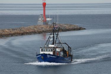
When you’re looking to start an oyster farm, there are a lot of environmental factors to consider. How cold is the water? What kinds of algae are found there, and how abundant are they? How do weather and water conditions change throughout the year? All of these factors influence how fast an oyster can grow, how much they have to eat, their likelihood of survival—and your farm’s bottom line.
Determining these factors and finding the best farm location can take a great deal of time and money. However, using satellite data, a dedicated team of researchers aims to help aquaculture growers.
NOAA’s National Environmental Satellite Data and Information Service’s CoastWatch and NOAA Fisheries partnered to adapt a new satellite-derived Habitat Suitability Index to identify productive regions for seafood farming. Using satellite imagery, they can collect data on a number of water quality parameters quickly and efficiently.
Satellites are uniquely valuable because they routinely collect large amounts of data over vast areas. These kinds of data are only available from space.
“Remote sensing helps take the guesswork out of shellfish farming, providing ocean intelligence to guide better siting decisions,” said Ken Riley, science branch chief for the Office of Aquaculture. “By peering down from space, we can monitor water quality, temperature, and ocean conditions, ensuring shellfish farms are placed in optimal locations.”
Studying Shellfish Suitability from Space
Scientists analyzed data from two satellites, NASA’s Landsat-8 and the European Space Agency’s Sentinel-2, for the Damariscotta River in the Gulf of Maine. They followed the methods of a published study from the University of Maine. The Damariscotta River estuary has a thriving oyster industry, making it an ideal place to conduct this study.
The satellites measured sea surface temperature, plankton abundance, and water clarity. All of these factors impact how quickly oysters grow, their likelihood of survival, and when they spawn. These data were used to calculate an oyster habitat suitability index based on the ecology and life cycle of Eastern oysters.

The researchers then used the habitat suitability index to generate seasonal maps of growing conditions for the oysters. These highlighted both suitable and unsuitable regions to grow oysters. They also went back in time to 2016, giving farmers a historic look at environmental conditions relevant to their oysters. This data-driven method is more efficient than trial-and-error approaches, giving farmers the best available information with which to make decisions.
Even beyond site selection, the index continues to be useful in farm management. Farmers are able to use satellite data to monitor environmental conditions and take proactive measures to protect their shellfish.
"Growing” American Seafood Security

While the U.S. is a world leader in aquaculture science and technology, we rank 20th in production. In 2022, the U.S. imported more than $29 billion in seafood from abroad.
Growing the domestic aquaculture industry can help address the increasing demand for seafood and reduce the seafood trade deficit.
Habitat suitability indices have the potential to be adapted for offshore aquaculture development and the identification of Aquaculture Opportunity Areas. These indices could be adapted to include different farmed seafood species such as mussels, scallops, seaweeds, and finfish.
For example, NOAA CoastWatch researchers have worked with farmers and ecologists to formulate a habitat suitability index for blue mussels, an economically valuable species with very different growing conditions than oysters. The blue mussel habitat suitability index product was developed using additional satellite sensors to enhance spatial coverage in the offshore region. It includes more than a decade of data and shows that the offshore regions of the Gulf of Maine are ideal for mussel farming.
The goal is to make all this data available to the public, helping to ease the burden of data collection and location scouting for growers. This cutting-edge technology, which uses satellites to expand domestic aquaculture, is a powerful demonstration of NOAA’s science and contribution to the American economy.