Towering cliffs with falling rocks, open ocean sea conditions, and small reef-shelf ledges crowded with seals make the islands of Nihoa and Mokumanamana an intimidating and very difficult environment to survey for scientists from NOAA Fisheries’ Hawaiian Monk Seal Research Program. On a nice day, we need an 18-ft inflatable zodiac armored with protective covering, a skilled coxswain at the helm, good timing, and grippy shoes just to get a team ashore. Nosing the small boat up to the reef shelf in-between sets of waves allows just enough time for a few stealthy scientists to scamper up the slippery ledges to collect data.

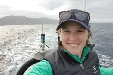
NOAA seal team takes to the skies with an unmanned aerial system (UAS) to survey difficult-to-access land (Photo: NOAA Fisheries).
On a normal day, these so-called “landing areas" are washed out and too dangerous, so the seal team sails away empty handed. With only four chances a year to survey these islands during our camp deployment and recovery expeditions, the odds are not typically in the team’s favor. So why take on such obstacles year after year? Landing on foot allows scientists to move through the rugged terrain dotted with tide pools and boulders to collect data on seal numbers and identify individual seals. This work cannot be done from a small boat as the seals are often obscured and these surveys provide a complete data set that is essential to calculating an annual population estimate. For an endangered species like the Hawaiian monk seal, every survey feeds into population numbers from year to year, and matters particularly at these rarely visited locations that have become more important for monk seal recovery in recent years.
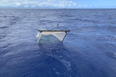
On May 3rd at Mokumanamana, the shore team landed at the main seal haul out called the Saddle, but could not surmount the Northeast ledge. This would have meant another incomplete population survey, had it not been for some new technology. From a small boat nearby, the UAS (unmanned aerial system) team buzzed in to finish the job, launching Tori, an APH-22 hexacopter. Tori flew over the jagged Northeast ledge, taking photos of monk seals to determine size, sex, and individual identifications.

Aerial view of Hawaiian monk seals on Mokumanamana. How many can you see? (Photo: NOAA Fisheries)
Surveying these islands by UAS comes with its own set of challenges. The sheer cliffs and strong trade winds create challenging flying conditions as wind swirls around the island. If that isn’t enough, there are thousands of birds that call the islands and the airspace their home. It takes a skilled team of pilot, observer, and boat coxswain to ensure that all birds, including the Tori, are kept safe. After countless hours of training, the team rose to the challenge.
The three-person UAS team successfully flew a total of 13 flights at Mokumanamana and Nihoa in May 2018. They identified monk seals at both locations, completed full population surveys, and ultimately maintained a valuable long-term data set. This mission marks the first UAS flights at Mokumanamana and the first time this tool has been used to complete full island monk seal surveys. UAS has proven itself a valuable instrument contributing to the Hawaiian Monk Seal Research Program’s scientific priorities while keeping NOAA personnel safe. There is no doubt it will be a key to our continued success in the future.

Eight Hawaiian monk seals visible in a photo from an unmanned aerial system (UAS) on the saddle of Mokumanamana. Could you find them all? (Photo: NOAA Fisheries)